Walk 1774 - printer friendly version
Priors Hardwick & Wormleighton Circular Walk
Author - Lou Johnson
Length - 8.0 miles / 13 km
Ascent - 500 feet / 152 metres
Grade - easy/mod
Start - OS grid reference SP448537
Lat 52.1797410 + Long -1.3462252
Postcode CV47 2XW (approx. location only)
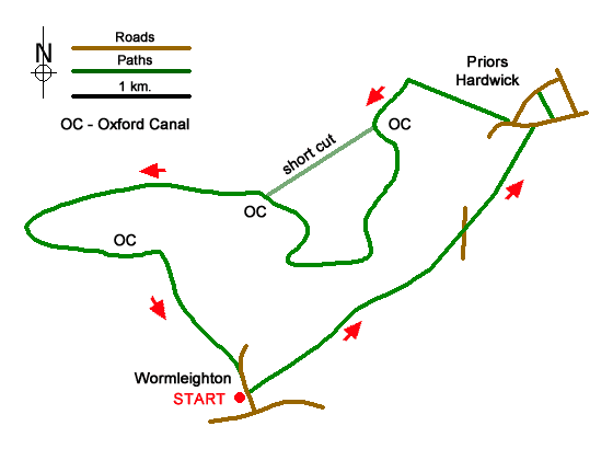
A circular walk from Wormleighton exploring pleasant countryside east to Priors Hardwick. Both villages have many stone cottages. The return route follows the Oxford Canal which snakes through the landscape with many twists and turns. Also of interest along the route are two deserted medieval villages, a fine 17th century gatehouse and a manor house with restored moat.
The walk starts in Wormleighton (grid ref. SP448537) where limited parking is available. The route starts by taking the un-waymarked track on the east side of the arched gateway. Continue through two gates to a large field. Cross the middle of the field to a gap in hedge. Maintain direction across the next field to a gap in the hedge by a fingerpost. Continue across next field bearing half right down to the northern end of Newfield Pool (grid ref. SP458545). Cross the bridge and head up across the next pasture to wards Stoneton Manor with its large, restored moat. Bear left onto the access driveway and where this bends right continue ahead across a field to reach a gate which gives access to a lane (grid ref. SP466551).
Cross the lane through a gate and head half left uphill towards a line of trees and a yellow waymark. Maintain direction through trees to a gate. Walk half right to the crest of the slope. Bear left to a gate by a tree. Continue past Fox Cover (on your left) to pass through a gate. Head down to a cottage (on your left) and continue ahead to a gate in the hedge leading to a lane. Turn right and follow the road as it bends right. Pass a house on the left and turn left through a gate into a paddock. Walk parallel to the road to another gate into a larger field. Once in the field, turn sharp left and with fence left continue across two fields to reach St Mary Church in Prior Hardwick.
Leave the churchyard on the west side and turn left passing the Butcher's Arms on your right. Continue to reach a road junction (grid ref. SP470560). Bear right towards Fenny Compton and follow the road around to the right. At the next junction, fork right down a narrow lane (no through road sign). Continue along lane for 320 metres and turn left through a gate (just as lane bends right). Follow bridleway beside hedge on your right to another gate. Continue ahead to reach the Oxford Canal (grid ref. SP461563).
Cross the bridge and descend to the towpath. Continue west with canal on your left. This route continues along the canal. (At the first bridge you can shorten the walk by a mile by leaving the canal and following footpaths southwest across several fields to re-join the canal.) The walk follows the towpath through to bridge 133 including the Wormleighton Loop. Leave the canal and cross the bridge and bear right to a stile in a hedge. Head half left across the site of the medieval village. Bear left at next fence and cross a stile in trees to join a tarmac driveway which leads back to the start.
Messaging & Social Media
Message Walking Britain and follow the latest news.

Mountain Weather
Stay safe on the mountains with detailed weather forecasts - for iOS devices or for Android devices.