Walberswick Circular
Suffolk Walk
County/Area - Suffolk
Author - Lou Johnson
Length - 4.5 miles / 7.3 km Ascent - 100 feet / 30 metres
Time - 2 hours 20 minutes Grade - easy
Maps 

| Ordnance Survey Explorer 231 | Sheet Map | 1:25k | BUY |
| Anquet OS Explorer 231 | Digital Map | 1:25k | BUY |
Walk Route Description
Click image to see photo description.
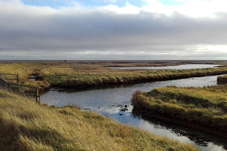
A pleasant circular walk from Walberswick on the Suffolk Coast. The route includes a beach, salt marshes, heathland, old windmills, and the estuary of the River Blyth. The walk starts from the free car park on Ferry Road, Walberswick (grid ref. TM500748). After parking walk to the eastern end of the car park and walk towards the beach across a bridge over the River Dunwich. Continue ahead through the dunes to the beach and turn right along the head of the beach.
Continue with the sea on your left passing beach huts on your right. After 800 metres (before information board) turn right towards two footbridges. Cross the first and continue to the second. Do not cross this bridge but turn left along the riverbank. Continue on a boardwalk with water to your left and follow the signs for the Suffolk Coast Path.
Reaching a ruined mill (grid ref. TM487737), leave the Coast Path and turn right along a gravel path between salt marshes (Oldtown Marshes). Reaching trees bear left through a gate and then turn right along the edge of Sheep Hill keeping a fence on your right. Veer right through a kissing gate and continue to Lodge Road (grid ref. TM480742).
Cross Lodge Road and go half left on the bridleway opposite. Continue to reach the edge of a wood (Sallow Wood Covert) and bear right with the trees on your left. Continue to the end of the wood. Follow path right (signed to Sandlings Walk) and continue through a gate. Continue across a field to reach the B1387 by Eastwood Lodge. Turn right along the road and then left onto a bridleway (again signed Sandlings Walk). Follow the clear path across Walberswick Common keeping ahead to join tarmac Palmer's Lane.
Follow this lane to reach the River Blyth. Do not cross the bridge and turn right with river on your left. Continue along the river back to the start.
Other walks nearby
| Walk 2014 | Southwold | easy | 4.0 miles |
| Walk 3603 | Blythburgh from Wenhaston | easy | 5.0 miles |
| Walk 1529 | Aldeburgh and Thorpeness Circular | easy/mod | 8.5 miles |
| Walk 2237 | Somerleyton & Herringfleet Hills | easy | 3.5 miles |
| Walk 2428 | The Rivers Ore & Alde from Orford | easy/mod | 11.0 miles |
| Walk 2075 | Tyrrel's Wood and Boudicca Way | easy/mod | 8.5 miles |
| Walk 1834 | Shelton & Fritton Common from Tyrrels Wood | easy/mod | 7.0 miles |
| Walk 2446 | Rockland St Mary Circular | easy/mod | 8.1 miles |
| Walk 3348 | River Yare & Claxton from Rockland Staithe | easy | 5.2 miles |
| Walk 2239 | River Bure and Tunstall Dike from Acle | easy | 6.1 miles |
Recommended Books & eBooks
Suffolk Coast and Heath Walks
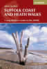 Guidebook to three long-distance routes exploring the varied landscapes of the Suffolk Coast and Heaths AONB. The Suffolk Coast Path covers 55 to 60 miles from Lowestoft to Felixstowe. The Stour and Orwell Walk is 40 miles from Felixstowe to Cattawade near Manningtree, while the Sandlings Walk is 59 miles from Ipswich to Southwold.
More information
Messaging & Social Media
Message Walking Britain and follow the latest news.

Mountain Weather
Stay safe on the mountains with detailed weather forecasts - for iOS devices or for Android devices.