Walk 1778 - printer friendly version
Maenporth and Helford Passage Circular Walk
Author - Lou Johnson
Length - 8.0 miles / 13 km
Ascent - 1100 feet / 333 metres
Grade - easy/mod
Start - OS grid reference SW789196
Lat 50.0353900 + Long -5.0888776
Postcode TR12 6NU (approx. location only)
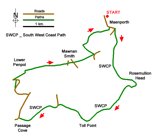
This walk from Maenporth follows the South West Coast Path around Rosemullion Head and Toll Point to reach Helford Passage. The route then turns inland and passes through Mawnan Smith to return to the start. As with many coastal walks the cliff top path undulates with frequent 'ups and downs'. The inland section follows paths and lanes and does involve two short climbs.
The walk starts from the car park behind the beach at Maenporth (grid ref. SW789196). After parking walk south with the sea to your left. At the end of the beach the road starts to rise. Take the signed path to Mawnan Church on the left (South West Coast Path). You soon reach the cliff top where its is better to follow the path nearest the sea. The path soon descends to Bream Cove before a short climb leads to Rosemullion Head. Again, stay on the path nearest the sea.
The path continues south soon entering trees. (If you have time and energy, a path on the right leads up to Mawnan Church.) Continue along the South West Coast Path descending to Port Saxon. From here an undulating path leads along the cliffs to reach you briefly join a lane that leads to Durgan Beach and village. Pass through the village and bear right past a letter box in a wall. Then turn left onto the coast path signed to Helford Passage. Continue to Polgwidden Cove where the route follows a concrete road for a short way. The path bears left off the concrete and continues through to Helford Passage and a lane (grid ref. SW764269).
Turn right up the lane and continue ahead for 800 metres to reach a crossroads (grid ref. SW767276) where you turn left. Continue straight on ignoring side roads on your left. About 500 metres from the crossroads, bear left on a signed footpath by a bungalow named 'Gate Acre'. The path descends a field to join a track which leads back to the lane. Turn left on the lane and almost immediately right to follow an access track which leads to Lower Penpoll. Follow the signs through the farm and continue across three fields with hedge on your left to reach Higher Penpoll (grid ref. SW772285).
Turn right past a house and continue a short distance down to a stone stile on your left. Cross the stile into a field and continue with hedge right. The path continues with hedge left to cross a stile by a pole (grid ref. SW777285). Continue down an enclosed path between houses to Grove Hill in Mawnan Smith. Cross the road and take path between metal barriers. Continue to a road and turn right. After 80 metres turn left onto signed footpath to Meudon. Continue along path to reach a farm (grid ref. SW786288).
At the farm turn left into the valley. The path crosses several fields to reach a stream (grid ref. SW782290). Turn right just before the stream and walk along the edge of the trees to reach a gate. Pass through the gate into the woodland. You soon reach a fork in the path where you bear left and continue back to the road in Maenporth. Turn left and the start is a short distance along this road.
Messaging & Social Media
Message Walking Britain and follow the latest news.

Mountain Weather
Stay safe on the mountains with detailed weather forecasts - for iOS devices or for Android devices.