Walk 1782 - printer friendly version
Steyning Round Hill and No Man's Land Walk
Author - Hugh Maguire
Length - 7.5 miles / 12.2 km
Ascent - 1000 feet / 303 metres
Grade - moderate
Start - OS grid reference TQ170106
Lat 50.883055 + Long -0.33816019
Postcode BN44 3LF (approx. location only)
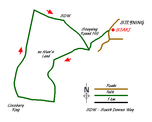
This walk explores some interesting country north of Steyning. Steyning, approached using the A283, is a beautiful Sussex village nestling under the South Downs. To park your car at the start of this walk you need to find a cul-de-sac at grid ref TQ170106. Turn left out of the cul-de-sac, follow the road for a bit before taking the steep path south west straight up Steyning Round Hill. About halfway up is a gate and you keep on the path until you reach a bench where you turn left.
At the junction of paths (grid ref. TQ163100), where there is a sort of memorial, go west to No Man's Land and another junction of paths (Grid ref. TQ151097). From here go south down a beautiful valley until you reach a large track where you head west to the car park at the foot of Cissbury Ring (Grid ref TQ140085).
Turn north and follow a fairly wide track until you reach the South Downs Way (Grid ref TQ145114). Turn east here along the South Downs Way until you come to the junction of paths by the memorial. Turn north here and make your way back via the bench and the car park to your car.
Messaging & Social Media
Message Walking Britain and follow the latest news.

Mountain Weather
Stay safe on the mountains with detailed weather forecasts - for iOS devices or for Android devices.