Walk 1787 - printer friendly version
Pembridge, Eardisland & the Arrow Valley Walk
Author - Lou Johnson
Length - 7.4 miles / 12 km
Ascent - 250 feet / 76 metres
Grade - easy/mod
Start - OS grid reference SO391582
Lat 52.2186290 + Long -2.8928522
Postcode HR6 9ES (approx. location only)
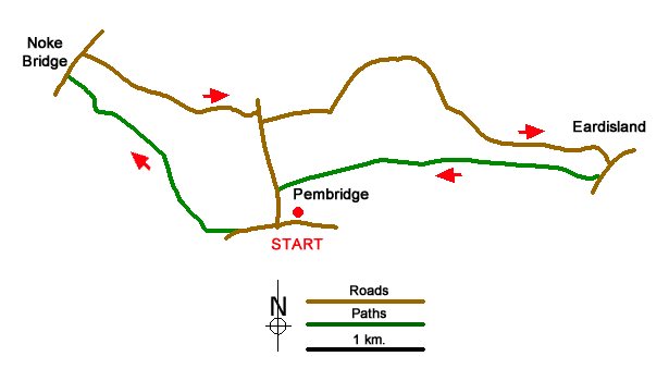
This walk starts from the attractive Herefordshire village of Pembridge and explores the Arrow Valley. The route also includes the opportunity to explore Eardisland, another village with many half-timbered cottages. The start is the signed public car park off East Street in Pembridge (grid ref. SO391582).
Exit the car park and turn right along East Street (A44). Continue ahead into High Street, pass the Red Lion on the left and then ahead into West Street. Continue almost to the end of the village and take the signed footpath on the right through a kissing gate (grid ref. SO387581). Go half-left across a field to reach a gate which leads onto a track. Turn right to a fork. Take the left-hand track and go through a gate into a field. Follow the hedge on your right to a stile. Bear slightly left in this field to and cross two stiles before crossing a disused railway line (grid ref. SO381587).
The path continues with hedge on your left and continues to a track. Turn left along the track which runs close to the River Arrow on your right. After 450 metres the track bends left and reaches gate (grid ref. SO375591). Bear right in the next field and follow the path that parallels the hedge on your right. Reaching a road, turn right (note - this is a busy highway). You soon pass a fine house on the left (Court of Noke) and then cross Noke Bridge over the River Arrow.
After 250 metres, turn right onto a quieter lane (signed The Leen). Continue ahead for 1.5 km. to a road junction. Turn right and then next left along Broome Lane. Continue for four kilometres between pastures and orchards passing Twyford, Broom and Folly Farms. Continue into Eardisland to reach the main road through the village (grid ref. SO 420587).
Turn right and continue to pass a telephone box on the right and the White Swan on the left. Then turn right through wooden kissing gate with fingerpost. Cross two fields, a small bridge and turn right (grid ref. SO416586). Continue with the hedge on your right to descend steps and go through a gate. Bear left into a field and then follow the right-hand field edge. The waymarked path then crosses several stiles maintaining a westerly direction. Continue through Long Meadow (Open Access). At the far end of Long Meadow, follow track to reach a road (grid ref. SO391585). Turn left and continue to the A44. Turn left and the car park used at the start is a short way along East Street on the left.
Messaging & Social Media
Message Walking Britain and follow the latest news.

Mountain Weather
Stay safe on the mountains with detailed weather forecasts - for iOS devices or for Android devices.