Edinburgh - Salisbury Crags and the Royal Mile
Edinburgh Walk
County/Area - Edinburgh
Author - Lou Johnson
Length - 4.0 miles / 6.5 km Ascent - 750 feet / 227 metres
Time - 2 hours 50 minutes Grade - easy
Maps 

| Ordnance Survey Explorer 350 | Sheet Map | 1:25k | BUY |
| Anquet OS Explorer 350 | Digital Map | 1:25k | BUY |
| Ordnance Survey Landranger 66 | Sheet Map | 1:50k | BUY |
| Anquet OS Landranger 66 | Digital Map | 1:50k | BUY |
Walk Route Description
Click image to visit gallery of 6 images.
This easy walk enables you to visit some of the sightseeing highlights of Edinburgh city centre and also to enjoy the natural beauty of the parkland surrounding Arthur's Seat. The focus of the city is Princes Street, which is lined with shops on one side and flanked by Princes Street Gardens on the other. Overlooking this scene is Edinburgh Castle. No attempt has been made to offer a detailed description of the many sights that are passed during the walk as there are many excellent guide books that cover this type of detail.
This walk starts from the Scott Monument (Grid ref. NT255739) on the south side of Princes Street. From here, walk east towards Waverley Station. Turn right over Waverley Bridge and then continue straight ahead on Cockburn Street, which climbs up to join High Street (The Royal Mile). Turn left down High Street and continue past John Knox's House into Cannongate to pass along the north side of the Scottish Parliament building, which can be seen through the railings on your right. Turn right into Horse Wynd and pass in front of the Scottish Parliament building with its contemporary style. The gardens are very pleasant and link the building with the open country opposite.
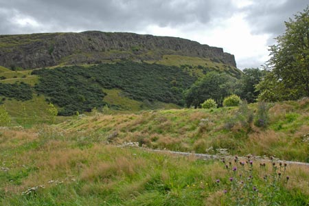
The next objective is opposite. Here you will see Salisbury Crags and beyond the summit of Arthur's Seat. This walk uses the well maintained path the lies directly below Salisbury Crags. Use the pedestrian crossing to cross the road and start walking the main path that contours beneath the Crags. The views are immediately good with a wide panorama over Edinburgh, including Holyrood House, the Scottish Parliament, the Castle and many other sights within the city. Continue past the South Quarry. Sadly climbing is not allowed. Reaching the road at the far end of the crags, turn left and follow a wide path that runs beneath Arthur's Seat and parallel with Salisbury Crags, which are on your left. This is the Volunteer's Walk. Continue along this path descending gradually towards Queens' Drive, which runs along the side of the grounds surrounding the Palace of Holyrood House. Turn left towards the Scottish Parliament and enter the gardens in front of the main building.
Retrace you route up the Royal Mile passing St Giles Cathedral on your left. Reaching Lawnmarket, turn sharp right down Bank Street and descend towards the Mound and The National Gallery. From here you can enter Princes Street Gardens or stay at street level to return to the start.
Other walks nearby
| Walk 3292 | Carnethy Hill, Black Hill & Caerketton Hill | mod/hard | 12.5 miles |
| Walk 3291 | West Kip, East Kip & Scald Law | moderate | 9.7 miles |
| Walk 1936 | Scald Law and Pentland Hills Ridge from near Penicuik | mod/hard | 7.4 miles |
| Walk 2241 | Gladhouse Reservoir | easy | 4.0 miles |
| Walk 1979 | Culross Heritage | easy | 1.5 miles |
| Walk 3281 | East Lomond from Craigmead | easy | 2.5 miles |
| Walk 3282 | West Lomond from Craigmead | easy/mod | 5.0 miles |
| Walk 1962 | Lower Largo to Elie - Fife Coastal Path | easy/mod | 7.4 miles |
| Walk 3280 | West Lomond from near Gateside | moderate | 6.8 miles |
| Walk 1562 | Elie to Pittenweem - Fife Coastal Path | easy | 6.0 miles |
Recommended Books & eBooks
No suggestions for this area.Messaging & Social Media
Message Walking Britain and follow the latest news.

Mountain Weather
Stay safe on the mountains with detailed weather forecasts - for iOS devices or for Android devices.