Downham & Pendle Hill Walk
Walk 1818 - Route Maps
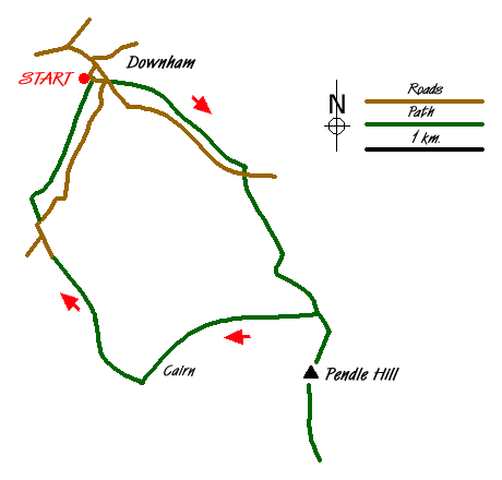
Route Map
Digital Maps - Copyright © 2011-2024. All rights reserved.
Sketch Map
Suggested Maps 

| Ordnance Survey Explorer OL41 | Sheet Map | 1:25k | BUY |
| Anquet OS Explorer OL41 | Digital Map | 1:25k | BUY |
| Ordnance Survey Landranger 103 | Sheet Map | 1:50k | BUY |
| Anquet OS Landranger 103 | Digital Map | 1:50k | BUY |
It is recommended you take a map. The preferred scale is 1:25k.
Start Point Details
Ordnance Survey Grid Ref SD785440
Latitude 53.891728 Longitude -2.328624
Postcode BB7 4BS
what3words start decks.sheep.upholding
Walk description may contain detailed information on the start point for this walk.
Further Information
Forest of Bowland
The Forest of Bowland walks cater for walkers of all abilities from easy low-level walks to walks across the hills and moors. All walks are free to download and print and all routes have GPS files. The walks cover the highlights of this area including Pendle Hill, Whin Fell and Dunsop Fell as well the valleys and moors of this beautiful part of England. Forest of Bowland Walking Guide
Lancashire
Lancashire offers many walking opportunities with a number of areas of high ground. The highest point is Gragareth (near Whernside) at 627 metres. The rivers drain west from the Pennines. The coast is backed by a coastal plain. Excellent areas for walking include Arnside and Silverdale National Landscape, Beacon Fell Country Park and the Forest of Bowland AONB, which includes Pendle Hill. Further south are the West Pennine Moors and the Forest of Rossendale.
Walk grading - Learn how each walk is assessed and select a walk to suit your ability and experience by going to Walk Grading Details.
Messaging & Social Media
Message Walking Britain and follow the latest news.

Mountain Weather
Stay safe on the mountains with detailed weather forecasts - for iOS devices or for Android devices.