Mam Tor & Hollins Cross from Mam Nick
Peak District Walk
Nat Park - Peak District - Great Ridge Castleton
County/Area - Derbyshire
Author - Lou Johnson
Length - 3.0 miles / 4.9 km Ascent - 700 feet / 212 metres
Time - 2 hours 10 minutes Grade - easy
Maps 

| Ordnance Survey Explorer OL1 | Sheet Map | 1:25k | BUY |
| Anquet OS Explorer OL1 | Digital Map | 1:25k | BUY |
| Ordnance Survey Landranger 110 | Sheet Map | 1:50k | BUY |
| Anquet OS Landranger 110 | Digital Map | 1:50k | BUY |
Walk Route Description
Click image to see photo description.
This short Peak District walk includes the most dramatic section of Castleton's Great Ridge with expansive views to the north and south across a wide area of the National Park. The route follows well used paths throughout although appropriate footwear is still recommended.
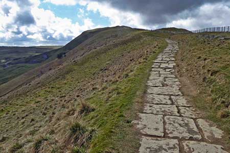
The start is the pay and display car park (grid ref. SK123832) below Mam Nick. After parking exit on the northern side of the car park climbing up to the road below Mam Nick. Continue by taking the path off to the right which climbs, steeply in places to reach the summit of Mam Tor. To the north the view covers with wide valley of Edale with the Kinder Plateau beyond. Ahead is the Great Ridge which terminates at Lose Hill. To the south lies Castleton with the hills and dales of the White Peak forming a scenic background.
To continue descend on the flagged path walking east towards Lose Hill. The path descends gently reaching a crossroads of paths at Hollins Cross in just under a mile (grid ref. SK136845). From Hollins Cross the onward path descends to your right, doubling back down towards Mam Farm (grid ref. SK133841). Continue down to reach a track and bear right past Mam Farm, which is to your left. Stay on the track and continue ahead to reach the remaining section of the old road (grid ref. SK132838). Go straight ahead on the old road which was destroyed during a major landslip when a large section of the southern face of Mam Tor slid into the valley.
Reaching the access road for Blue John Cavern (grid ref. SK131832), turn left and continue towards this famous show cave. At the end of the access road, turn right onto a signed footpath which leads to Winnats Head Farm (grid ref. SK130829). Here bear right with the farm to your left and continue across fields to reach a road (grid ref. SK127829). Cross the road and take the footpath opposite. This leads northwest across rough ground to reach another road. Turn left along the road and the car park is on your right.
Other walks nearby
| Walk 1688 | Old Dam & Sparrowpit from Mam Nick | moderate | 9.0 miles |
| Walk 1159 | Grindsbrook & Edale Head | moderate | 7.5 miles |
| Walk 1264 | Rushup Edge & Crowden Tower | moderate | 10.0 miles |
| Walk 1295 | Ringing Roger & Edale Cross | moderate | 10.0 miles |
| Walk 2595 | Castleton Great Ridge from Edale | moderate | 8.5 miles |
| Walk 2615 | The Kinder Edges | mod/hard | 18.0 miles |
| Walk 3350 | Kinder Scout Summit | moderate | 8.5 miles |
| Walk 1113 | Ringing Roger & Grindslow Knoll | moderate | 5.5 miles |
| Walk 1300 | Hope Cross & Ringing Roger | moderate | 8.0 miles |
| Walk 2378 | Rushup Edge & Mam Tor | moderate | 10.0 miles |
Recommended Books & eBooks
Dark Peak Walks
 Guidebook to 40 walks in the Dark Peak area of the Peak District National Park. 35 circular routes for most abilities, from 8km to 19km, around Edale, Marsden, Fairholmes, Baslow and Castleton, including Kinder Scout and Mam Tor, and 5 longer (25km to 45km) routes highlighting the best of the Gritstone Edges, High Moorland and Deep Valleys.
More information
Great Mountain Days in the Pennines
 An inspirational guidebook to 50 classic walks on the rolling Pennine landscape. The graded routes, between 6 and 13 miles in length, cover classic Pennine fells and moorland such as Whernside, Ilkley Moor and Pendle Hill; exploring the North and South Pennines, Yorkshire Dales, Howgills and Dark Peak. Many routes are also suited to fell running.
More information
Messaging & Social Media
Message Walking Britain and follow the latest news.

Mountain Weather
Stay safe on the mountains with detailed weather forecasts - for iOS devices or for Android devices.