Blease Fell & Hare Shaw from Tebay Walk
Walk 1839 - Route Maps & Profile
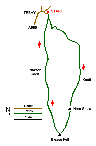
Route Map
Digital Maps - Copyright © 2011-2024. All rights reserved.
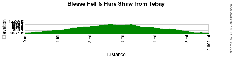
Route Profile
Sketch Map
Suggested Maps 

| Ordnance Survey Explorer OL19 | Sheet Map | 1:25k | BUY |
| Anquet OS Explorer OL19 | Digital Map | 1:25k | BUY |
It is recommended you take a map. The preferred scale is 1:25k.
Start Point Details
Ordnance Survey Grid Ref NY618044
Latitude 54.433574 Longitude -2.590396
Postcode CA10 3TP
what3words start crucially.padlock.minute
Walk description may contain detailed information on the start point for this walk.
Further Information
Howgills
Situated east of the Lake District, the Howgills lie mostly within the boundaries of the Yorkshire Dales National Park. The Howgills are one of the forgotten walking areas in England. The "hippo like" outlines of the fells are distinctive, most often seen by those tearing up the M6 motorway between Kendal and Penrith. Despite the lack of crags it is great walking country and you can wander for hours in the knowledge you are unlikely to meet more than a handful of other people. Poor parking (except in Sedbergh and a few other areas) helps to keep the number of people wandering the Howgills to a minimum. Howgills Walking Guide
Cumbria
Cumbria is one of the finest places for walking in Britain with rugged peaks, rolling hills, lakes and valleys providing a wonderful variety of landscapes. Cumbria includes the Lake District National Park, the Howgill Fells, part of the Yorkshire Dales National Park and the highest peaks of the North Pennines so who could ask for more? Sections of the Coast to Coast, Dales Way and Pennine Way long distance paths can also be explored.
Walk grading - Learn how each walk is assessed and select a walk to suit your ability and experience by going to Walk Grading Details.
Messaging & Social Media
Message Walking Britain and follow the latest news.

Mountain Weather
Stay safe on the mountains with detailed weather forecasts - for iOS devices or for Android devices.