Walk 1863 - printer friendly version
Ronas Hill, Mainland Walk
Author - Lou Johnson
Length - 4.0 miles / 6.5 km
Ascent - 1050 feet / 318 metres
Grade - moderate
Start - OS grid reference HU329837
Lat 60.535533 + Long -1.4022839
Postcode ZE2 9RX (approx. location only)
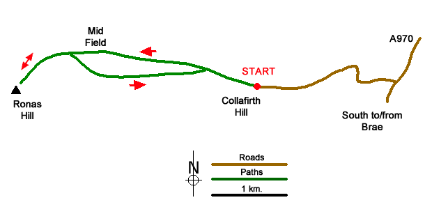
This walk to the summit of Ronas Hill (450 m.), the highest point on Shetland, offers superb views across mainland and beyond. Choose a fine day to make the ascent as the area is renowned for strong winds and poor visibility. The scenic journey north along the A970 from Lerwick takes you through a landscape of low hills and Lochs with few signs of habitation.
To reach the start follow the single track A970 north through South and North Collafirth and take the first tarmac track on the left (grid ref. HU352836). This track leads to a radio station on top of Collafirth Hill (233 m.). After parking walk just north of west aiming for the cairn on Man O'Scord (grid ref. HU329837). The ground can be wet underfoot. On reaching the cairn continue west towards the summit of Mid Field. Keep to the right of the cairn on Roga Filed and continue over this grassy hill to the summit of Mid Field (grid ref. HU316839). From Here you have a good view to Ronas Hill which lies to the south-west.
Initially descend west from Mid Field passing between two small lochans in the col below. Start your ascent of Ronas Hill. Its is quite steep at first but the gradient eases as you need the summit. Take time to enjoy the superb view. A map will help you identify the many features of the extensive panorama. Also of interest on the summit is a Neolithic single chambered cairn and a trig point enclosed by walls which offers some protection if the winds area strong.
To return to the start follow your outward route down to the two small lochans. Bear right and contour across the south flank of Mid Field avoiding wet ground and continuing to the cairn on Roga Field. From here head to the cairn on Man O'Scord and return to the radio station.
Messaging & Social Media
Message Walking Britain and follow the latest news.

Mountain Weather
Stay safe on the mountains with detailed weather forecasts - for iOS devices or for Android devices.