Glen Quoich & Glen Lui (near Braemar)
Cairngorms Walk
Nat Park - Cairngorms - Cairngorm South
County/Area - Aberdeenshire
Author - Lou Johnson
Length - 10.0 miles / 16.3 km Ascent - 1100 feet / 333 metres
Time - 6 hours 10 minutes Grade - moderate
Maps 

| Ordnance Survey Explorer OL58 | Sheet Map | 1:25k | BUY |
| Anquet OS Explorer OL58 | Digital Map | 1:25k | BUY |
Walk Route Description
Click image to see photo description.
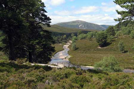
This walk near Braemar takes you into glorious scenery amidst some high Munros in the southern part of the Cairngorm National Park. The route climbs gently through the Linn of Quoich to reach Glen Quoich. The onward route then climbs into the Clais Fhearnaig pass to descend into Glen Lui which is followed back to the road from where tracks lead alongside the River Dee back to the start.
The start is the pay and display car park in an abandoned quarry near the Linn of Quoich (grid ref. NO116910). The car park is reached by leaving Braemar on the road to Linn of Dee and then turning east along the north bank of the River Dee to the car park. After parking continue east along the road, cross the bridge, and turn left along the path/track beside the river. The path continues through pine trees to cross a footbridge. Continue along the clear rising path to join a track (grid ref. NO112914). Continue up Glen Quoich. After three kilometres from the bridge the view opens out with the massive bulk of Beinn a'Bhuird (1197 m.) dominating the view.
The track descends to cross a side burn (grid ref. NO080937). After a few metres turn left on a rising path. Keep to the left of a hut in a fenced enclosure and continue across moorland into the Clais Fhearnaig gully. Continue ahead passing a small loch and a lochan on your left. The path keeps to the right of a boggy valley before descending into Glen Lui and a clear track (grid ref. NO059923).
Turn left and follow the river downstream (on your right). Reaching a bridge, keep ahead and follow the track uphill to a stile over a deer fence. Ignore any tracks left and right and descend into the valley and a road (grid ref. NO086900). Turn left along the road and then take the first track on the right towards Mar Lodge. Continue along the tarmac drive to the front of the lodge where your veer right towards the river. Just before Victoria Bride, take track on the left into woodland. Pass through several gates to regain the road. Bear right along the road to return to the car park used at the start of the walk.
Other walks nearby
| Walk 3108 | Creag Choinnich circular | easy/mod | 4.0 miles |
| Walk 2706 | Morrone (Morven) | moderate | 7.4 miles |
| Walk 1119 | Ben Macdui & Carn a' Mhaim | hard | 19.0 miles |
| Walk 2356 | The Cairnwell ridge from Glenshee Ski Centre | mod/hard | 9.3 miles |
| Walk 1881 | Ben Macdui & Cairn Lochan from the Ski Centre | hard | 10.4 miles |
| Walk 2672 | Cairngorm Mountain via Coire an t-Sneachda | mod/hard | 6.0 miles |
| Walk 1390 | Cairn Lochan via the Fiacaill Buttress from Ski Centre | very hard | 5.7 miles |
| Walk 1276 | Loch Avon Circular via Cairn Gorm Mountain | hard | 9.0 miles |
| Walk 2314 | Cairngorm & Ben Macdui from the ski centre | hard | 11.0 miles |
| Walk 2421 | Braeriach via the Chalamain Gap | hard | 15.0 miles |
Recommended Books & eBooks
Great Mountain Days in Scotland
 Inspirational guidebook to 50 challenging routes for mountaineers, scramblers, hillwalkers and fell runners, many long enough to backpack over 2 days, especially in winter (12 to 25 miles). A mix of classic routes and unsung gems across Scotland from Galloway to the Outer Hebrides in widely differing wild landscapes. With customised OS mapping.
More information
Messaging & Social Media
Message Walking Britain and follow the latest news.

Mountain Weather
Stay safe on the mountains with detailed weather forecasts - for iOS devices or for Android devices.