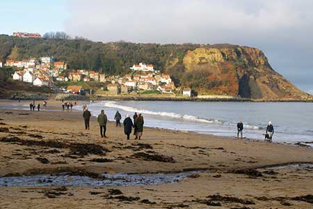
Runswick Bay & Kettleness
North York Moors Walk
Nat Park - North York Moors - North York Moors East
County/Area - North Yorkshire
Author - Lou Johnson
Length - 9.0 miles / 14.6 km Ascent - 1300 feet / 394 metres
Time - 5 hours 50 minutes Grade - moderate
Walk Route Description
Click image to see photo description.
This walk from Runswick Bay, in the North York Moors National Park, combines a costal section of the Cleveland Way with an inland section following the disused track-bed of the railway between Saltburn and Whitby. The route follows well signed paths and tracks and should present no navigational difficulties.
The walk starts from the cliff-top pay and display car park at Runswick Bay (grid ref. NZ807161). An alternative car park is at Bank Bottom behind the beach (grid ref. NZ809160). From the top car park walk to the exit and turn right onto the Cleveland passing between wooden posts. Follow the path as it loops down to Ban Bottom. Turn left towards the beach passing the alternative car park on your right. Descend to a black and yellow barrier and bear right onto a path which soon drops down to the beach. Continue along the beach for 600 metres to reach a cleft in the cliffs (grid ref. 815154). Turn right and follow the path uphill with some sections stepped.
After a steady climb you reach the cliff top and pass a welcome seat if you need a rest. After just over a kilometre of easy walking on an often grassy path, the path turns inland beside a deep valley before swinging left to enter Kettleness (grid ref. NZ829156). Keep to the left of a stone barn to regain the cliff-top path. After two kilometres of pleasant walking, you reach a three-way fingerpost (grid ref. NZ850145). Turn right signed to Lythe.
Turn inland along the path for just under 200 metres and turn right. Continue along the right-hand side of two fields to join the access track to Overdale Farm. Continue ahead along the track to join Golsborough Lane. Turn right, follow the lane around to the left and continue ahead into the village of Goldsborough. Pass a phone box on your left, continue straight across the next junction. 80 metres the junction, turn right onto a signed path (grid ref. NZ835147). Keep to the left of the buildings to enter a large field. Walk half left across this field. Enter the second field and aim to the immediate right of a small stone barn to join a lane (grid ref. NZ833154).
Turn right along the lane and after 200 metres turn left onto the former railway. Continue along the clear path for four kilometres to Low House (grid ref. NZ807151). Turn right down Cloverdale Lane. Initially a track it soon becomes a path which descends to the beach. Turn left and retrace your route back to Runswick Bay where the village is worth exploring. Note If you have parked at the cliff top car park you can continue ahead along the old railway at Low House. Reaching a road, turn right back to the start.
Maps 

| Ordnance Survey Explorer OL27 | Sheet Map | 1:25k | BUY |
| Anquet OS Explorer OL27 | Digital Map | 1:25k | BUY |
| Ordnance Survey Digital Map Subscription | |||
| Latest Ordnance Survey Discounts | |||
Other walks nearby
| Walk 2091 | Kettleness and Mickleby from Lythe | moderate | 9.7 miles |
| Walk 1476 | Boulby Mine to Whitby by the Cleveland Way | moderate | 12.5 miles |
| Walk 1452 | Leaholm Moor & Scaling Dam | moderate | 9.8 miles |
| Walk 2090 | Easington Beck & Staithes from Loftus | moderate | 11.5 miles |
| Walk 1012 | Glaisdale, Great Fryup Dale and Eskdale | moderate | 7.5 miles |
| Walk 1841 | Saltburn and Skelton from Skinningrove | moderate | 10.4 miles |
| Walk 1464 | Sleights Moor | easy/mod | 7.8 miles |
| Walk 1450 | Little & Great Fryup Dales | moderate | 8.3 miles |
| Walk 3737 | Commondale & Esk Valley | easy/mod | 8.2 miles |
| Walk 1675 | The Esk Valley & Egton High Moor | moderate | 10.5 miles |
Recommended Books & eBooks
Trail and Fell Running in the Yorkshire Dales
 Guidebook to 40 of the best trail and fell runs in the Yorkshire Dales National Park. Ranging from 5 to 24 miles, the graded runs start from bases such as Ribblehead, Dent, Sedbergh, Malham and Grassington and take in the region's diverse delights, from castles and waterfalls to iconic mountains such as Whernside, Ingleborough and Pen Y Ghent.
More information
The Cleveland Way Map Booklet
 Map booklet of the Cleveland Way National Trail, a 177km (110 mile) walk around the North York Moors National Park. This booklet is included with the Cicerone guidebook to the Cleveland Way and the Yorkshire Wolds Way, and shows the full route of the Cleveland Way on Ordnance Survey 1:25,000 maps.
More information
