Harter Fell and Low Birker Tarn from Hardknott Pass
Lake District Walk
Nat Park - Lake District - Lake District Southern Fells
Wainwrights - Harter Fell
County/Area - Cumbria
Author - Peter Smyly
Length - 6.5 miles / 10.6 km Ascent - 1900 feet / 576 metres
Time - 5 hours 10 minutes Grade - moderate
Maps 

| Ordnance Survey Explorer OL6 | Sheet Map | 1:25k | BUY |
| Anquet OS Explorer OL6 | Digital Map | 1:25k | BUY |
| Ordnance Survey Landranger 89 | Sheet Map | 1:50k | BUY |
| Anquet OS Landranger 89 | Digital Map | 1:50k | BUY |
Walk Route Description
Click image to visit gallery of 6 images.
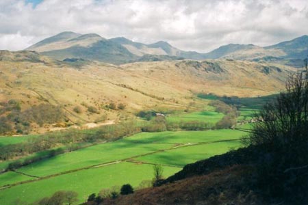
Harter Fell has an altitude of 2,128 feet and is situated in a relatively isolated position overlooking the Eskdale valley. As it does not readily link up with any other mountains, it does not see many walkers. However, its' isolation does give it one main plus point, and that is the all round view that it commands, particularly towards the Scafell range and the Coniston mountains. Harter Fell is situated between the Eskdale and Duddon valleys, which means that each valley offers a starting point and this route starts from Eskdale. For the most part, this is a walk of gentle gradients, but there is one notable exception.
The Lake District walk starts from the car park at the foot of the Hardknott Pass and follows a path roughly south west in parallel to the main valley. It starts easily enough and then leads gradually upwards along the side of the lower reaches of Harter Fell with views of the Eskdale valley opening up below to the right with the Scafell range in the background. After the path contours Harter Fell in a south to south east direction for about half a mile without any noticeable height gain, it suddenly branches off to the left and takes a "route one" approach to the top. This is the one really steep section that is likely to increase your heart rate before long as the route climbs somewhat unrelentingly up the grassy felllside. It is not until it nearly reaches the upper reaches of the mountain that the gradient eases off. The summit area, which has a trig point to mark the very top, is notable for its outcrops of clusters of rocks which offer scrambling opportunities.
The author takes the view that tarns, as well as summits, are worthwhile walk objectives and therefore the return route takes in Low Birker Tarn, rather than repeating the outgoing route in reverse.
Walk back down the steep path to the junction with the path from Eskdale which you then follow (now to the right) for about a quarter of a mile before leaving the path and walking across pathless ground between Dow Crag and Kepple Crag to reach the tarn.
Low Birker Tarn is one of the prettier, but less well-known, tarns in the Lake District. Choose a day like the one in the photo, and it may appear as a royal blue colour. Through the crystal clear waters of the tarn, in places, submerged tree roots can be seen. Green Crag provides a good backdrop to a photo of the tarn as well as offering an alternative area to explore on the return route.
A clear path leads down back to Eskdale, zig-zagging in places to Low Birker Farm and then back along a path to the east by Penny Hill Farm to rejoin the car park.
Other walks nearby
| Walk 2467 | Green Crag & Harter Fell | moderate | 7.9 miles |
| Walk 1299 | Green Crag | moderate | 6.5 miles |
| Walk 2361 | Scafell & Slight Side | hard | 9.5 miles |
| Walk 2362 | Scafell Pike and Scafell | very hard | 11.0 miles |
| Walk 2675 | Eel Tarn and Stony Tarn | easy/mod | 6.0 miles |
| Walk 2229 | Tarns of Eskdale | easy/mod | 7.5 miles |
| Walk 1932 | Slight Side from Whahouse Bridge | moderate | 5.6 miles |
| Walk 2355 | Blea Tarn & Eskdale Green | easy/mod | 6.5 miles |
| Walk 3508 | The Crinkle Crags from Wrynose Pass | easy/mod | 5.0 miles |
| Walk 1176 | Yewbarrow | moderate | 4.5 miles |
Recommended Books & eBooks
Outdoor Adventures with Children - Lake District
 Guidebook to 40 outdoor adventures in the Lake District with children under 12, including walking, cycling, orienteering, paddling, boating, hostelling and more. Graded activities for varying age ranges or for families with children of different ages.
More information
Walking the Lake District Fells - Buttermere
 Part of the Walking the Lake District Fells series, this guidebook covers a wide range of routes to 32 Lakeland summits that can be climbed from the Buttermere, Lorton and Newlands valleys, with highlights including Haystacks, High Stile, Grasmoor and the fells of the Coledale Round. Suggestions for longer ridge routes are also included.
More information
Messaging & Social Media
Message Walking Britain and follow the latest news.

Mountain Weather
Stay safe on the mountains with detailed weather forecasts - for iOS devices or for Android devices.