Lydeard Hill to Wills Neck
Quantock Hills Walk
Region - Quantock Hills
County/Area - Somerset
Author - Philip Churchyard
Length - 2.6 miles / 4.2 km Ascent - 400 feet / 121 metres
Time - 1 hours 40 minutes Grade - easy
Maps 

| Ordnance Survey Explorer 140 | Sheet Map | 1:25k | BUY |
| Anquet OS Explorer 140 | Digital Map | 1:25k | BUY |
Walk Route Description
Click image to see photo description.
From the car park take the cattle gate on the west side and take the gravel track keeping the fence on your immediate left. Follow this path across Lydeard Hill and then down an incline where another cattle gate takes you into unenclosed land with Bagborough Plantation on the left and views down Aisholt Common on your right.
At the west end of the plantation the path begins to climb (ignore any paths off left or right) and the views begin to open up on both sides as you move onto the open moorland proper.
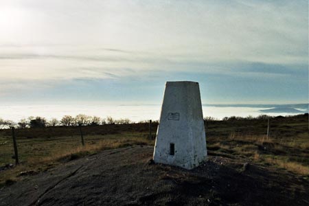
A stroll of about half a mile up a gradual incline brings you to the trig point on the summit of Wills Neck, the highest point of the Quantock Hills with views all round - the Bristol Channel and South Wales to the north, Glastonbury, Wells and the Somerset Levels to the east and the Blackdown and Brendon Hills with Exmoor behind to the south and west.
Return to the car park by the same route.
Other walks nearby
| Walk 1925 | Plainfield to Wills Neck | easy | 5.0 miles |
| Walk 3211 | Crowcombe & Wills Neck | moderate | 7.3 miles |
| Walk 2330 | Quantock Hills from Dead Woman's Ditch | moderate | 9.2 miles |
| Walk 1822 | Hodder's Combe, Bicknoller Post & Higher Hare Knap | easy/mod | 5.8 miles |
| Walk 3412 | Dowsborough Fort from Holford | easy/mod | 6.0 miles |
| Walk 1696 | Weacombe Combe, Bicknoller Post, Kilve & Longstone Hill | easy/mod | 7.5 miles |
| Walk 2940 | Beacon Hill & Bicknoller Post from Kilve Beach | easy/mod | 7.0 miles |
| Walk 1856 | Lilstock & East Quantox Head | easy/mod | 8.4 miles |
| Walk 1973 | River Parrett from Pawlett | easy/mod | 7.1 miles |
| Walk 1978 | Blackdown Hills & Castle Neroche | easy/mod | 6.8 miles |
Recommended Books & eBooks
No suggestions for this area.Messaging & Social Media
Message Walking Britain and follow the latest news.

Mountain Weather
Stay safe on the mountains with detailed weather forecasts - for iOS devices or for Android devices.