Walk 1924 - printer friendly version
Lydeard Hill to Wills Neck Walk
Author - Philip Churchyard
Length - 2.6 miles / 4.2 km
Ascent - 400 feet / 121 metres
Grade - easy
Start - OS grid reference ST181338
Lat 51.097634 + Long -3.1709891
Postcode TA4 3DY (approx. location only)
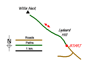
From the car park take the cattle gate on the west side and take the gravel track keeping the fence on your immediate left. Follow this path across Lydeard Hill and then down an incline where another cattle gate takes you into unenclosed land with Bagborough Plantation on the left and views down Aisholt Common on your right.
At the west end of the plantation the path begins to climb (ignore any paths off left or right) and the views begin to open up on both sides as you move onto the open moorland proper.
A stroll of about half a mile up a gradual incline brings you to the trig point on the summit of Wills Neck, the highest point of the Quantock Hills with views all round - the Bristol Channel and South Wales to the north, Glastonbury, Wells and the Somerset Levels to the east and the Blackdown and Brendon Hills with Exmoor behind to the south and west.
Return to the car park by the same route.
Messaging & Social Media
Message Walking Britain and follow the latest news.

Mountain Weather
Stay safe on the mountains with detailed weather forecasts - for iOS devices or for Android devices.