Walk 1928 - printer friendly version
Pewsey Downs from Wootton Rivers Walk
Author - Lou Johnson
Length - 8.0 miles / 13 km
Ascent - 700 feet / 212 metres
Grade - easy/mod
Start - OS grid reference SU197630
Lat 51.3657260 + Long -1.7184164
Postcode SN8 4NH (approx. location only)
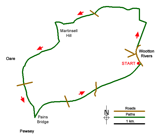
This Wiltshire walk offers a range of scenery from rolling downs to the open aspect of the Vale of Pewsey. The start is the small car park adjacent to the village hall in the village of Wootton Rivers (grid ref. SU197630). Exit the car park and walk north through the village to join the Mid Wilts Way which leaves the road on your left at grid ref. SU197634. Follow this path north for just under a mile climbing onto the downs. Reaching a path junction at grid ref. SU199642 turn left, following the Mid Wilts Way and continue when the path turns right to meet Mud Lane (grid ref. SU198646).
Turn left along Mud Lane for two miles continuing along the Mid Wilts Way. The way ahead climbs steadily across the rolling downs crossing a lane at grid ref. SU183645. Continue straight ahead with a steep escarpment to your left with an excellent view across the Vale of Pewsey. Reaching a path junction (grid ref. SU176642) continue straight ahead. At a cross-path (grid ref. SU174641) go straight ahead and continue along the southern edge of Withy Copse to reach a cross path (grid ref. SU171641). Turn left here to join the White Horse Trail to continue along a ridge passing Giant's Grave. Continue to descend to a cross path (grid ref. SU161628). Go straight across and continue south to reach Sunnyhill Lane (grid ref. SU161622).
Cross Sunnyhill Lane and take the path opposite remaining on the White Horse Trail to reach Pains Bridge (grid ref. SU164611) on the Kennet and Avon Canal. Turn left along the canal towpath for two and a half miles of easy walking back to Wootton Rivers.
Messaging & Social Media
Message Walking Britain and follow the latest news.

Mountain Weather
Stay safe on the mountains with detailed weather forecasts - for iOS devices or for Android devices.