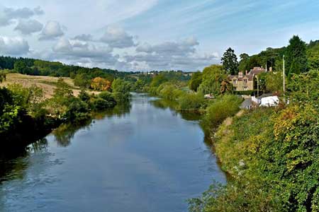
Wyre Forest & River Severn from Upper Arley
Worcestershire Walk
County/Area - Worcestershire
Author - Lou Johnson
Length - 7.6 miles / 12.4 km Ascent - 600 feet / 182 metres
Time - 4 hours 20 minutes Grade - easy/mod
Maps 

| Ordnance Survey Explorer 218 | Sheet Map | 1:25k | BUY |
| Anquet OS Explorer 218 | Digital Map | 1:25k | BUY |
| Ordnance Survey Landranger 138 | Sheet Map | 1:50k | BUY |
| Anquet OS Landranger 138 | Digital Map | 1:50k | BUY |
Walk Route Description
Click image to see photo description.
This walk through rural Worcestershire includes a wide variety of landscapes from the Wyre forest to the banks of the River Severn. The start is the attractive small village of Upper Arley where there is a small pay and display car park (grid ref SO763802). The village has a café and other refreshment opportunities.
After parking walk into the centre of the village and turn right across the substantial footbridge over the River Severn. Continue along the lane crossing over the Severn Valley Railway with its regular service of steam trains. Continue uphill for about 600 metres to reach signed footpaths on your left (grid ref. SO761795). Turn left and take the footpath almost immediately on your right. This path leads across fields to a track and continues in a south-westerly direction to a road (grid ref. SO758788). Reaching the road, turn right and within a few yards take the footpath on your left. This leads across a field to a path junction. Turn left and continue between the trees to the road at Pound Green.
Continue straight ahead along the road walking south to reach the B4194 near Buttonoak. Turn left, and keeping the grass verge on the left, walk as far as St Andrew's church on your right. Just past the church turn right into the Wyre Forest following the yellow waymarks. Continue to reach Dowles Brook (grid ref. SO758768). Turn left here along a clear track for just over one and a half miles to reach the B4194. Turn right and in a short way take the footpath on the left. This path leads down to the River Severn (grid ref. SO779764). Turn left along the river following the North Worcestershire Path for 3 miles back to the start. As you near Upper Arley you pass under the impressive Victoria Bridge which carries the Severn Valley Railway across the river in a single span.
Other walks nearby
| Walk 2466 | The Severn Valley from Trimpley Reservoir | easy | 6.0 miles |
| Walk 2288 | Pound Green and Dowles Brook from Hawkbatch | easy | 5.0 miles |
| Walk 3504 | Highley to Bewdley along the River Severn | easy/mod | 7.0 miles |
| Walk 2092 | Highley from the Severn Valley Country Park | easy/mod | 4.5 miles |
| Walk 2131 | Wyre Forest National Nature Reserve, Bewdley | easy | 3.3 miles |
| Walk 1603 | Shatterford Wood and Castle Hill circular | easy/mod | 5.5 miles |
| Walk 2248 | Wimperhill Wood and Longdon Orchard, Wyre Forest | easy | 4.0 miles |
| Walk 2807 | The River Severn from Hampton Loade to Bridgnorth | easy/mod | 6.0 miles |
| Walk 3217 | Bewdley and Snuffmill Dingle | easy | 5.0 miles |
| Walk 2874 | Enville Estate and the Sheepwalks | easy | 4.0 miles |
Recommended Books & eBooks
No suggestions for this area.Messaging & Social Media
Message Walking Britain and follow the latest news.

Mountain Weather
Stay safe on the mountains with detailed weather forecasts - for iOS devices or for Android devices.