Walk 1942 - printer friendly version
Watson's Pike & Hexhamshire Common Walk
Author - Lou Johnson
Length - 6.0 miles / 9.8 km
Ascent - 700 feet / 212 metres
Grade - easy/mod
Start - OS grid reference NY902543
Lat 54.883354 + Long -2.1542808
Postcode NE47 0HR (approx. location only)
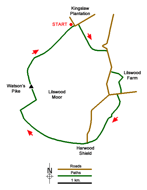
This Northumberland walk crosses rural farmland and continues to visit the summit of Watson's Pike in an area of open moorland. The start is the 'parking' area near the southwest corner of Kingslaw Plantation (grid ref. NY902543) which lies about 3 miles southwest from the small village of Whitley Chapel.
After parking walk northeast along the road in the direction of Whitley Chapel with Kingslaw Plantation on your immediate left. At the end of the trees, take the waymarked path on your right across a small footbridge and a stile. Follow the path across a large pasture with the fence to your right. Reaching a fence junction take the stile on your right and continue ahead in the same direction as before. The path drops down to cross a stream just above a waterfall. There is some wet ground and its is better to keep to the high ground eventually keeping the boundary fence to your right. Continue to the stile in the right-hand corner of the field and join the road (grid ref. NY911537).
Turn right and walk uphill passing a caravan park on the left to reach a road junction. Continue straight ahead passing Lilwood Cottage and Lilwood Grange, both of which are on your right. Shortly after Lilwood Grange take the waymarked footpath on the left (grid ref. NY912531). Cross the stile and follow the wall (on your right) which bears right and leads to Lilwood Farm. Here, bear right along the farm access road for about 150 metres where you turn left through a gate and follow the footpath to High Lilswood Farm. Keep the farm on your left and the small pond to your right. Cross the stile on the right and continue to a lane (grid ref. NY914526).
Turn right along the lane. Take the next left (a tarmac lane or drive) and continue to the house named Folly on OS maps. Here, take the footpath on the right and continue across fields to Stobby Lea (grid ref. NY912520). Bear right onto the bridleway (a track) passing the main farm buildings on your left. Ignore the farm's access track on your right and bear left to follow the bridleway. This bridleway is hard to follow in places and a 1:25000 map is useful. Cross the footbridge at grid ref. NY909515) from where you continue southwest to Harwood Shield Farm. Pass between the farm buildings and turn left on a dirt track. Almost immediately turn right at grid ref. NY906513 on a track signed to Allendale.
Follow this track until you reach the end of the fence on your right. Where the track forks, take the right-hand track to reach a T-junction (grid ref. NY888521). When birds are nesting on the moors between March and July) you will need to turn left here for 300 metres to reach a marker post where you turn right along a bridleway across wild moorland. This path, The Broad Way on OS maps leads back to the start. Outside of the nesting season, turn right and continue along the track to a turning circle at its end (grid ref. NY892524). From here careful navigation is required by turning left off the track and heading just wet of north to reach the cairn on the summit of Watson's Pike (grid ref. NY891528). To continue head north to drop down to the Broad Way, turning right along this bridleway to the start.
Messaging & Social Media
Message Walking Britain and follow the latest news.

Mountain Weather
Stay safe on the mountains with detailed weather forecasts - for iOS devices or for Android devices.