Valley of Desolation & Simon's Seat from Barden Bridge
Yorkshire Dales Walk
Nat Park - Yorkshire Dales - Lower Wharfedale
County/Area - North Yorkshire
Author - Lou Johnson
Length - 8.4 miles / 13.7 km Ascent - 1500 feet / 455 metres
Time - 5 hours 40 minutes Grade - moderate
Maps 

| Ordnance Survey Explorer OL2 | Sheet Map | 1:25k | BUY |
| Anquet OS Explorer OL2 | Digital Map | 1:25k | BUY |
Walk Route Description
Click image to see photo description.
This Yorkshire Dales walk includes riverside paths, woodland, moorland, two rocky summits and wonderful views over Wharfedale and Nidderdale. The route follows good paths throughout and with few navigation problems. The start is the small riverside car park adjacent to the River Wharfe at Barden Bridge (grid ref. SE052573) just west of the B6160 between Bolton Abbey and Burnsall. It is worth noting that dogs are not allowed on the moorland sector of this walk.
From the car park head south along the east bank of the River Wharfe following a delightful section of the Dale Way with the River to your left. The path stays on the east bank as far as a substantial stone bridge where it crosses to the other bank. The Dales Way passes through beautiful woodland to the Strid where the River Wharfe squeezes through a narrow rocky defile before regaining a more gentler flow a few hundred metres downstream. Continuing through woodland maintained by the Bolton Abbey Estate you reach a wooden bridge (marked as such on the OS 1:25000 map) at grid ref. SE077552.
Cross the bridge and turn left along the clear footpath along the river bank heading upstream with the river on your left. After a short way the path rises to join a tarmac lane. Follow the lane and climb slightly to reach a gatehouse on your right. Adjacent to this is a waymarked path signed "Simon's Seat". Take this path passing through pastures at first but soon entering a valley. You will notice a footbridge down on your left (Grid ref. SE078566). Cross this and follow the narrow path upstream to pass a waterfall.
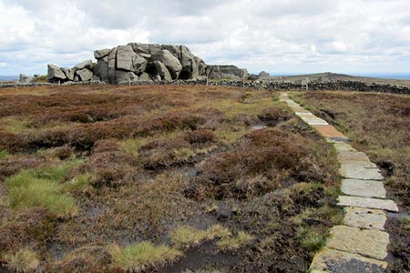
Above the waterfall you enter the 'Valley of Desolation', which despite its name provides pleasant walking. The onward path soon enters a conifer plantation. The path through this is soon completed and you exit onto open moorland. The onward path is obvious and climbing gently the gritstone rocks that mark the summit of Simon's Seat soon come into view which is the next objective. The bird's eye perspective of Wharfedale is particularly fine and it is a perfect place for a break. A short optional visit may be made to Lord's Seat, which lies about 500 metres east. This sees fewer visitors and offers views towards Nidderdale.
To continue head southwest from Simon's Seat on a narrower path. This descends to a wall which is followed (keep wall to your right). Stay on the descending path beside the wall to join a track signed to 'Howgil'. Follow the track down by the wall and fence. Cross the stile by a gate following the path to a junction between gates. Keep ahead descending. The path curves right. Bear left at the next junction. After a barn go right signed to 'Howgill'. Stay on the track go straight ahead at a junction of tracks to reach a road. Cross the road and join the Dales Way heading south along the east bank of the River Wharfe. This leads pleasantly to Barden Bridge where the walk started.
Other walks nearby
| Walk 1001 | Barden Bridge & the Strid | easy | 4.0 miles |
| Walk 1249 | Simon's Seat | moderate | 10.0 miles |
| Walk 2574 | Valley of Desolation & Barden Fell | moderate | 11.0 miles |
| Walk 1280 | Trollers Gill | moderate | 9.0 miles |
| Walk 2000 | Wharfedale Circular | moderate | 13.5 miles |
| Walk 1576 | Embsay Reservoir | easy | 1.0 miles |
| Walk 2610 | Hebden Gill & Cupola Corner | easy/mod | 6.5 miles |
| Walk 2611 | Hebden Gill from Hebden | easy | 4.0 miles |
| Walk 1573 | Grimwith Reservoir | easy | 4.5 miles |
| Walk 1292 | Linton & Thorpe Fell & Cracoe | moderate | 9.0 miles |
Recommended Books & eBooks
Walking in the Yorkshire Dales: North and East
 This guidebook contains 43 circular day walks in the north and east Yorkshire Dales. It explores the dales, hills and moors between Kirkby Stephen and Pateley Bridge. Walking ranges from gentle 3 mile strolls to more strenuous day-long rambles across the Howgills, Wensleydale, Swaledale, Nidderdale, Mallerstang and Coverdale.
More information
The Dales Way
 An essential guidebook to walking the Dales Way. This picturesque 78 mile long distance route through the Yorkshire Dales between Ilkley and Bowness on Windermere is one of the gentlest multi-day walks in Britain. The route is described in both directions, visiting Grassington, Kettlewell, Buckden, Dent, Sedbergh and Staveley en route to Bowness.
More information
Messaging & Social Media
Message Walking Britain and follow the latest news.

Mountain Weather
Stay safe on the mountains with detailed weather forecasts - for iOS devices or for Android devices.