Walk 1947 - printer friendly version
Coombe Gibbet & Walbury Hill near Inkpen Walk
Author - Lou Johnson
Length - 6.2 miles / 10.1 km
Ascent - 700 feet / 212 metres
Grade - easy/mod
Start - OS grid reference SU379615
Lat 51.35132 + Long -1.4571606
Postcode RG17 9EH (approx. location only)
This Berkshire walk enjoys the wonderful vistas from Gallows Down and Wal bury Hill and explores the rural countryside and villages lying to north of the chalk escarpment. Gallows Down was the site of a gibbet where the criminals involved in a 17th century murder were hung. Today the downs offer a perfect spot for hang gliders to soar into the skies.
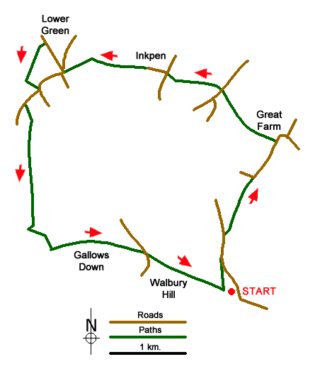
The start is the parking area adjacent to the minor road south of Inkpen at the eastern end of Walbury Hill (grid ref. SU379615). After parking walk west along the signed byway leading to Walbury Hill. After about 200 metres take the footpath on the right which descends across grass. Cross two stiles and walk through a small area of woodland to reach a road junction (grid ref. SU378622). Cross the road and take the signed footpath opposite. Keep to the left-hand edge of the field, pass Adder's Copse on your left to reach a lane at a bend (grid ref. SU381629).
Continue straight ahead here towards West Woodhay. Continue for 500 metres to a signed restricted byway on the left opposite a walled garden on the right. Turn left along the byway passing a few houses on the right. Continue past Prosser's Farm to reach Great Common Road (grid ref. SU378639). If you need refreshment the Crown and Garter pub is a short walk on the left. To continue go straight across onto another byway. Take the second left to follow a clear woodland path which then continues as a track. Emerging from the trees near a thatched cottage, and after a few metres, go right along a grassy path between fields to reach a road in Inkpen at a metal barrier (grid ref. SU372641).
Go right then take the first lane on the left (Pottery Lane). After just under 300 metres, where the road bends to the right, take the footpath on the left-hand side of the road (grid ref. SU369641). Cross the field to a road at a wooden gate (grid ref. SU366641). Cross the road and take the signed footpath to the right of the driveway leading to Manor Farm. Cross a boardwalk and a footbridge and stay on the path to reach a Weavers Road in Lower Green (grid ref. SU360641).
Turn right and then bear left along Craven Road which is signed to Hungerford (with the telephone box to your right) and continue past the Swan Inn which is also on your right. About 200 metres after the pub and just after passing Vale Farm on the right, turn left onto a signed footpath (grid ref. SU358644). Cross the small field to reach Sands Drove (a track) where you turn left. Turn left at the junction to join a road by a grassy triangle. Turn right (signed to Ham) and continue to just past the "Inkpen" village sign to take a waymarked track on the left (grid ref. SU355637).
The track soon bears to the right with a good view of the chalk escarpment ahead. The path continues, with the field boundary on your right, and heads almost due south towards the chalk downs. At the end of the field where the tracks bears to the right, go left onto a path into an area of trees to reach a stile. Once over the stile you start an ascent onto the ridge. The path goes half left lessening the grade with improving views as you gain height. At the top, walk right and then left through a gate which leads to a broad track along the ridge of Inkpen Hill.
Go left along the ridge following a wide track to reach Gallows Down and Coombe Gibbet. Take time to enjoy the superb views in all directions. The track heads downhill to reach a road (grid ref. SU369620). Go straight across and take the track to the right of the parking area with a fence on your immediate right. Reaching the top of the Walbury Hill - the true summit is marked by a trig point an easy stroll away to the right - before descending back to the start.
Messaging & Social Media
Message Walking Britain and follow the latest news.

Mountain Weather
Stay safe on the mountains with detailed weather forecasts - for iOS devices or for Android devices.