Walk 2008 - printer friendly version
Hart Fell via Saddle Yoke & the Black Hope Horseshoe Walk
Author - Simon Tweedie
Length - 8.5 miles / 13.8 km
Ascent - 3000 feet / 909 metres
Grade - mod/hard
Start - OS grid reference NT148098
Lat 55.374761 + Long -3.3460188
Postcode DG10 9LQ (approx. location only)
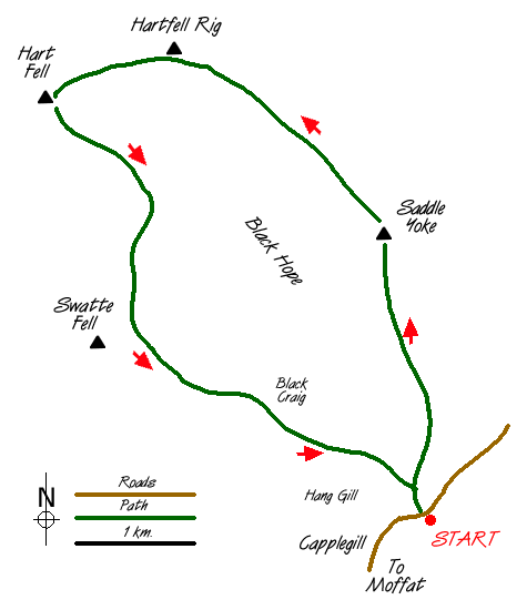
This relatively tough excursion in the Southern Uplands of Scotland provides superb views and a challenging route. Park by the Black Hope cottage near Capplegill farm (grid ref. NT148098) about 7 miles from Moffat on the A708 Selkirk road. Pass through the gate next to the cottage and follow the farm track until a second gate is reached. Strike off up the grassy shoulder of Saddle Yoke. There is no defined path and the gradient is unremitting for 1500ft.
From the summit of Saddle Yoke the route drops down dramatically to a narrow grassy edge which forms a bridge across to Upper Saddle Yoke. From here carry on over the open moorland and peat hags down to Whirly Gill. From here follow the top of Saddle Craigs and continue up to Hart Fell, which provides a superb viewpoint of the glen and the route you are following.
The return journey is along the west leg of the horseshoe and skirts the tops of Hart Fell, Falcon, Coomb and Black Craigs. The best views are had close to the top of the cliffs although do take care if the visibility is poor. Of particular note is an interesting arete called the Hound Shoulder on Coomb Craigs. Not to be outdone Black Craig has a fine little grassy pinnacle which stands proudly above the Black Hope Glen some 1500ft below. It is well worth a visit but take care especially when it is slippery underfoot.
The descent to Capplegill is reasonably straight forward though the finish is steep. Care is needed to avoid Hang Gill, which is clearly marked on the Ordnance Survey map.
Messaging & Social Media
Message Walking Britain and follow the latest news.

Mountain Weather
Stay safe on the mountains with detailed weather forecasts - for iOS devices or for Android devices.