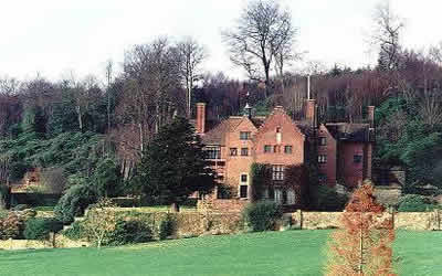
Chartwell from Crockham Hill
Kent Walk
County/Area - Kent
Author - Gary Janks
Length - 2.8 miles / 4.6 km Ascent - 500 feet / 152 metres
Time - 1 hours 50 minutes Grade - easy
Maps 

| Ordnance Survey Explorer 147 | Sheet Map | 1:25k | BUY |
| Anquet OS Explorer 147 | Digital Map | 1:25k | BUY |
| Ordnance Survey Landranger 188 | Sheet Map | 1:50k | BUY |
| Anquet OS Landranger 188 | Digital Map | 1:50k | BUY |
Walk Route Description
Click image to visit gallery of 2 images.
Start at The Royal Oak pub in Crockham Hill (grid ref. TQ442505), three or four miles south of Westerham in Kent. Walk up the hill from the pub on the left-hand side of the road and take the left fork into the village off the main road (B2026) and proceed up the road going past the quaint village houses on either side. Join and cross over the B269 road and walk up the right hand side of it until you come to the way marked footpath leading up and off to the right. Following this path will bring you to a car park. There are two footpaths to the right, take the more diagonal right hand turning that goes up the hill, which is way marked as the Greensand Way.
Walk through Crockhamhill Common until you come to the Hosey Common Road (B2026) and cross over, climb over the stile on the other side and walk to the top of the hill following the footpath to Chartwell house. At the top of the hill you will find you can either take a walk that goes off to the left which takes you down the hill until you come to the main entrance to Chartwell. Be careful as you climb down the steps on the footpath to the main road (Mapleton Road) that runs past Chartwell. Otherwise you can go straight on the footpath to the bottom until you also come out at the Chartwell house, but further up the Mapleton Road. Visit the house if you have the time and if it is open, as it offers a fascinating insight into the previous owner, Sir Winston Churchill.
Walk back up the second footpath mentioned above, that brought you to Chartwell, until at the top of the hill you find a footpath turning to the left. Take this until you come to a stile, climb over to take the footpath that leads along the right hand side of the cultivated field. If you follow this path along the outside of the field you will come to a spectacular view over Kent from the Greensand ridge at a point called Mariners Hill. In any case, you should go back and find the exit from the field over the stile continue along the path which descends to a tarred road. Turn left on the tarred road to Froghole a tiny hamlet that commands another excellent view from the ridge of the Kent fields below it.
When you have been along this road for a hundred metres or so you will find the way marked footpath on your right. Walk down the steep steps past a romantic thatched cottage and its pretty garden. Climb over the stile, follow the path to the next stile, climb over to the next stile into the field and walk along with a wonderful, "green and pleasant" view of the Greensand ridge and the homes of Froghole behind you, until you come to a church on your right where there is a stile on your left further on. Cross over and follow the tarred road until you come to the main road of the Crockham Hill village, turn left and cross over the B2026 and walk down the hill until you arrive back at The Royal Oak pub, where you can have a good pint of real ale and a delicious meal too.
Other walks nearby
| Walk 2284 | Limpsfield Circular | easy/mod | 6.0 miles |
| Walk 2427 | Hever & Markbeech from Chiddingstone | easy | 5.9 miles |
| Walk 3441 | Sevenoaks, Seal Chart and Ightham Mote | moderate | 11.0 miles |
| Walk 1510 | Otford, Romney Street & Woodlands | moderate | 14.5 miles |
| Walk 1610 | Otford, Romney Street & Kemsing | mod/hard | 16.8 miles |
| Walk 3598 | Knockholt via Pratt's Bottom, Mace Farm and The Washneys | easy/mod | 7.3 miles |
| Walk 2156 | Lullingstone Castle Circular | easy | 4.0 miles |
| Walk 2333 | Lullingstone & Preston Hill near Shoreham (Kent) | easy/mod | 6.6 miles |
| Walk 2683 | Farthing Downs and Happy Valley from Coulsdon South | easy/mod | 6.0 miles |
| Walk 2479 | Worth Way from Three Bridges, near Crawley | moderate | 14.0 miles |
Recommended Books & eBooks
Walking in Kent
 A guidebook describing 40 walks in the county of Kent. Covering west Kent and The Weald and north and east Kent, including the Kent Downs and the Greensand Hills. Walks of 5 to 9 miles explore rivers and coastline, beautiful countryside and historic villages. With outlines of 11 longer walks ranging from 15 to 163 miles.
More information
Messaging & Social Media
Message Walking Britain and follow the latest news.

Mountain Weather
Stay safe on the mountains with detailed weather forecasts - for iOS devices or for Android devices.