Walk 2015 - printer friendly version
The Meavy & Plym valleys from Shaugh Bridge Walk
Author - John Paterson
Length - 6.0 miles / 9.8 km
Ascent - 660 feet / 200 metres
Grade - moderate
Start - OS grid reference SX532636
Lat 50.453819 + Long -4.0692709
Postcode PL7 5HD (approx. location only)
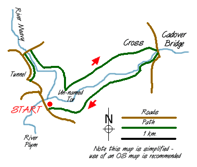
The southern fringes of Dartmoor are characterised by steep sided river valleys covered in dense oak woods above which lies the more traditional moorland which everyone associates with the moor. This walk of great variety explores two of those river valleys as well as some archaeological remains and a long abandoned railway tunnel. The walk can easily be split into two and reference to this is made in the text. In poor visibility (not uncommon on Dartmoor) a compass and map are essential for the stretch from the Dewerstone summit to Cadover Bridge - the rest of the route will give no problems in mist.
Note: This walk links to the walk from Plym Bridge to Bickleigh to give a route up the length of the Plym valley - see walk 2013 - details of the links are given at the foot of this page.
Shaugh Bridge car park is reached from the A38 trunk road through Plymouth by proceeding north on the A386 until a right turn (signposted Bickleigh) is made just after the roundabout north of Roborough. Follow this minor road for 3 miles through Bickleigh until Shaugh Bridge is crossed when a left turn can be made into a car park by old quarry buildings (Grid Ref: SX532636).
Leave the carpark and turn right onto the road signposted to Bickleigh and Roborough and proceed for just over half a mile until a minor road with no signpost is seen climbing to the right. Go up this road for a few yards until an entry can be made to an old railway platform signed "Shaugh Holt"(Grid ref. 527636). (Turning left along the track bed leads to Bickleigh and walk number A13 from Shaugh Bridge).
This route turns right onto the old trackbed which is followed north for a quarter of a mile until the entrance to Leighbeer tunnel is seen. Until 1999 negotiating the tunnel was quite an adventure as the curve meant that in the middle neither end could be seen - but now the surface underfoot is paved with concrete and lights every 100 feet make the trip less eventful. A few hundred yards after leaving the tunnel, leave the track bed where it runs alongside a minor road to the left. After a few yards on the road turn right onto a minor road which passes under the old railway and over the river Meavy (Grid ref. 528646).
After passing over the river turn right onto a track, an old tramway bed, which heads south east for half a mile until Dewerstone Cottage, now a Scout hut, is reached. If you follow the path down towards the river on the right at this point it can be followed to a foot bridge over the Plym back to your starting point at Shaugh Bridge. Our route continues on the old tramway contouring the hill through thick oak woods avoiding tracks to the right and left until the tramway ends at the summit of the Dewerstone Rocks one of Dartmoor's few climbing cliffs.(This point can be reached much more directly from the footbridge over the river Plym at Shaugh Bridge)
As soon as the Dewerstone summit rocks are seen, turn left and climb on faint tracks directly up the hill until you exit the woods at a small unnamed tor marked as a spot height of 227 metres on the OS map. Follow faint paths in a north easterly direction high above the gorge of the river Plym on your right then skirt the boundary wall of Lower Cadworthy Farm until one of Dartmoor's many old crosses is reached (Grid ref. 553647). From this point Sheeps Tor, Leather Tor and Sharpitor can be seen to the north - the course of the Plym towards its head can be seen to the east and the China Clay workings can be seen to the south east. From the cross it is a short walk downhill to Cadover Bridge which is crossed to reach the south bank of the river Plym.
Turn right after crossing the bridge and cross the informal car park which often has refreshments on sale in summer and at weekends in winter. At the western end of the car park a small path heads down river through North Wood. Once North Wood is left behind, superb views open up of the valley of the Plym with its oakwoods and the Dewerstone Rocks clearly visible across the valley. The path contours the valley until the woods above Shaugh Bridge are reached. Bear right steeply down through the woods back to the car park.
Links to Walk 2013 - Plym Bridge to Bickleigh -
1. From the west side of Shaugh Bridge a footpath follows the right bank of the Plym downstream to Bickleigh where a short walk (west) steeply up hill leads quickly to Bickeigh Station. (1.5 miles)
2. From "Shaugh Holt" Grid ref:SX527636 the old track bed can be followed south to a minor road where sign posts will point the short distance to Bickleigh Station (1mile)
Messaging & Social Media
Message Walking Britain and follow the latest news.

Mountain Weather
Stay safe on the mountains with detailed weather forecasts - for iOS devices or for Android devices.