Raven Crag, the Benn & Shoulthwaite Gill near Thirlmere
Lake District Walk
Nat Park - Lake District - Lake District Central Fells
Wainwrights - Raven Crag
County/Area - Cumbria
Author - John Paterson
Length - 4.0 miles / 6.5 km Ascent - 1000 feet / 303 metres
Time - 3 hours 0 minutes Grade - easy/mod
Maps 

| Ordnance Survey Explorer OL4 | Sheet Map | 1:25k | BUY |
| Anquet OS Explorer OL4 | Digital Map | 1:25k | BUY |
| Ordnance Survey Landranger 90 | Sheet Map | 1:50k | BUY |
| Anquet OS Landranger 90 | Digital Map | 1:50k | BUY |
Walk Route Description
Click image to visit gallery of 6 images.
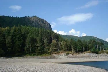
Raven Crag (1512ft) is a "Wainwright" and this short Lake District circular walk takes in two other distinct tops of well over 1000ft before dropping down to Shoulthwaite Gill. The area is passed each day in summer by thousands on the A591 between Grasmere and Keswick but few stop to sample the delights of this beautiful walk. Probably the fact that much of the walk is in woodland puts many off as they think that the views will not be up to much. They could not be more wrong as each top has magnificent views and the forest is not too dense for the most part with many clearings and good paths.
The "hidden valley" of Shoulthwaite Gill deserves to be better known being both peaceful and deserted most days of the year. By Lake District standards the route is fairly easy but a steep start and the importance of a map for route finding have given it a slightly higher grade. The photographs for this walk were taken in late September and the woods were full of spectacular fungi as one picture shows.
Leave the A591 (Grid ref. NY316194) and take the minor road leading west over Thirlmere dam to park at a small car park in the forest at the far end (Grid ref. NY307189). Walk north on a minor road for 100 yards until a gate on your left signposted "Castle Crag - Ancient Monument" gives access to the woods.
Follow the path steeply though mature pines until a track is reached with a gate into a young plantation seen ahead. Ignore the path though the plantation and turn left to follow the easy gradient of the forest track almost to the base of Raven Crag towering above. Just short of Raven Crag follow track as it bends to the right to skirt the young plantation. After 100 metres or so look for a path on your left (opposite the exit gate from the plantation). Climb steeply on this path through mature conifers until a saddle in a clearing is reached after 400 yards where 2 separate signs are seen. One points to Castle Crag and Shoulthwaite Gill the other sign to your left (south) points the way to Raven Crag. Follow the Raven Crag sign on a path which has been upgraded by the water authority until you break out of the conifers after a few hundred yards at the base of the small summit outcrop of the crag. An easy path (including some lengths of "boardwalk") leads quickly to the summit of Raven Crag (Grid ref. 303187) perched high above Thirlmere with superb views over the lake towards Helvellyn and the Dodds ridge above St Johns in the Vale.
Leave the summit and retrace the path back to the saddle where the 2 signs were seen. Follow the sign west to Castle Crag Hill Fort, first on a forest road and then after 50 yards or so another sign points to a smaller path on your right. Take this path and the remains of the fort (Grid ref. 300189) are reached after 400 yards or so. The fort consists of an earthwork surrounding a natural rock outcrop perched above Shoulthwaite Gill. Pass though a breach in the earthwork and take the short path rising anticlockwise to the summit. Looking north from the summit you will see another summit nearly half a mile away this is the summit of the Benn (our next objective - see picture) which is marked as a spot height of 446 metres on the 2.5 inch OS map. Just to the left of it partly hidden by trees is the steep face of Sippling Crag above Shoulthwaite Gill.
Retrace your route for 400 metres back to the clearing and follow the forestry road north for 100 yards or so until a faint path leads off through the woods to the right. Once in the woods follow the path in a northerly direction to reach the summit of the Benn (Grid ref. 302193) after just over 400 yards. There are great views back towards Raven Crag from the summit. There is a path leading north from the summit but it can be very overgrown. It is simpler to return south along the path towards the forest road and then bear right when the road is seen and then follow the forest road as it drops down to Shoulthwaite Gill.
Follow the road north as it follows the Gill downstream to a weir and foot bridge viewing point (Grid ref. 297200) - see picture. Soon after the weir follow the forest track as it leaves the Gill and contours back south round the foot of the Benn to pass Shoultwaite Moss (a marsh) on your left. A few hundred yards after the marsh pass through a gate and after 100 yards or so turn right onto a minor road at a second gate. Follow this minor road back to the car park after half a mile.
Other walks nearby
| Walk 1158 | High Rigg | easy | 5.5 miles |
| Walk 2005 | High Rigg & Legburthwaite | easy | 5.5 miles |
| Walk 2049 | Calfhow Pike & the Dodds from Legburthwaite | moderate | 7.5 miles |
| Walk 2524 | Thirlmere Circular | easy | 5.0 miles |
| Walk 3132 | High Tove & Blea Tarn | moderate | 7.6 miles |
| Walk 1247 | Helvellyn & Raise from Swirls | mod/hard | 7.0 miles |
| Walk 2025 | Helvellyn & Wythburn from Swirls | mod/hard | 8.5 miles |
| Walk 1108 | Ashness Bridge & Grange Fell | moderate | 9.0 miles |
| Walk 2525 | Standing Crag & Dock Tarn from Watendlath | moderate | 7.0 miles |
| Walk 2526 | Standing Crag, Ullscarf & Borrowdale | mod/hard | 10.0 miles |
Recommended Books & eBooks
Hadrian's Wall Path
 Hadrians Wall Path guidebook to walk the 84 mile National Trail. Described in both directions, the main description is west to east between Bowness-on-Solway and Wallsend, Newcastle, with extensions to Maryport and South Shields. With extensive historical information related to this World Heritage site and separate 1:25,000 OS map booklet included.
More information
Lake District: Low Level and Lake Walks
 This guidebook describes 30 of the best low-level walks in the Lake District. From delightful wooded glades and sparkling tarns, to waterfalls and glacier-carved valleys towered over by craggy mountains. The walks described aim to seek out the best walking that the lower areas of the Lake District have to offer.
More information
Messaging & Social Media
Message Walking Britain and follow the latest news.

Mountain Weather
Stay safe on the mountains with detailed weather forecasts - for iOS devices or for Android devices.