Helvellyn & Wythburn from Swirls
Lake District Walk
Nat Park - Lake District - Lake District Eastern Fells
Wainwrights - Helvellyn
County/Area - Cumbria
Author - John Paterson
Length - 8.5 miles / 13.8 km Ascent - 2700 feet / 818 metres
Time - 7 hours 0 minutes Grade - mod/hard
Maps 

| Ordnance Survey Explorer OL5 | Sheet Map | 1:25k | BUY |
| Anquet OS Explorer OL5 | Digital Map | 1:25k | BUY |
| Ordnance Survey Landranger 90 | Sheet Map | 1:50k | BUY |
| Anquet OS Landranger 90 | Digital Map | 1:50k | BUY |
Walk Route Description
Click image to visit gallery of 5 images.
Helvellyn, England's third highest mountain, presents two very different faces. The east side is craggy and famous for its two ridges Striding Edge and Swirral Edge. The west side consists of smoother convex slopes above Thirlmere. This less popular approach makes use of two paths above Thirlmere plus a walk of two miles through the woods above the lake. As such it provides an excellent Lake District walk with plenty of interest and fine views along the way.
The path from Swirls is the shortest route on the mountain. Being short it is very steep, but excellent footpath restoration in recent years makes it a good route of ascent. The descent to Wythburn is slightly longer as it zig zags across the fellside and puts less strain on the knees! Taken together these two paths provide the quickest circuit on the mountain. They are easy to follow and are very suitable (with head torches) for those hardy Brits who like to climb the mountain to see the sunrise on Christmas Day, New Year's Day or, more usually, Mid Summers Day. The route could be done anticlockwise but the descent to Swirls is very steep and hard on the legs. Parking at Wythburn and doing the route clockwise from there is feasible.
Remember, Helvellyn is a big mountain. In good summer conditions this route is within the capabilities of most, properly equipped, walkers. In mist or in winter conditions it is a serious undertaking and should only be tackled by those who are fit, well equipped and with good navigational and map reading skills.
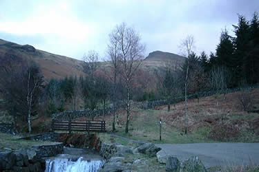
The car park at Swirls ( Grid ref. NY316168 ) is on the A591 Windermere to Keswick road, half a mile south of the Kings Head Inn at Thirlspot. The carpark is excellent with interpretation boards and toilet facilities with facilities for the disabled.
Leave the car park and cross over the footbridge to the left (north) bank of the gill. Follow the left bank until a signpost to Helvellyn directs you over another footbridge to the right bank. Now strike up the restored path up the fellside towards Brown Cove Crags. As the slope is convex most of the scenic interest lies in the unfolding panoramas of Thirlmere to the west and St Johns in the Vale, Skiddaw and Blencathra to the north.
The path steepens as it trends right to skirt the top of Brown Cove Crags. These are strangely named, as "Brown Cove" is on the other (eastern) side of the mountain. As the top of the crags is reached the path becomes a level path of red shale bending gently to the right (south east) towards the summit plateau. (Note: In mist if you find that you are on grey rock you are too close to the edge of the crags! If this happens - immediately head 30 yards south or south west to pick up the red shale path.) The red shale path is well cairned (some would say too well) and leads straight to the Ordnance Survey trig point on the summit plateau. The summit "cross" shelter is 150 yards south east of the trig point and provides shelter from winds in any direction. In snow and mist, if the path cannot be seen, it is safest to head for the shelter by heading south from the trig point and then turn east after about 150 yards to ensure that you don't stray over the east face. The small summit cairn is a few yards due north of the shelter. In snowy conditions the east face of Helvellyn always has a cornice - as a rule of thumb, stay at least twice as far from the edge as you think is safe.
On leaving the shelter take the shale path leading south towards Nethermost Pike. After a 40 yards the path passes the memorial stone to a landing by a light aircraft in 1926. The col between Helvellyn and Nethermost pike is reached after half a mile. In good visibility there is an excellent view back towards Striding Edge seen side on. At the col the path forks. The left fork rises towards Nethermost Pike and Dollywaggon Pike the right fork drops gently towards Wythburn. Take the right fork and follow the good path at a gentle angle which steepens slightly as you descend until a series of zig zags is reached culminating in the path swinging back towards Comb Gill above Wythburn. The path drops down towards the gill and then follows the southern (left) boundary of a plantation. Eventually the path enters the plantation at a stile and after a few hundred yards it is crossed by a forest road. A signpost points the way to Wythburn 200 yards below where there is an old church which can be visited if time permits. Our route turns right (north) though a gate on the forest road signposted to Swirls car park. Note: The route back to Swirls is mostly through woods and is 2 miles long. The forest roads cover only part of the way and the rest of the route is on a narrow path through thick trees. If darkness is falling and you do not have a head torch, it is sensible to drop down to Wythburn and follow the A591 north back to the carpark.
Other walks nearby
| Walk 3132 | High Tove & Blea Tarn | moderate | 7.6 miles |
| Walk 2019 | Raven Crag, the Benn & Shoulthwaite Gill near Thirlmere | easy/mod | 4.0 miles |
| Walk 2032 | Great How, a short ascent above Thirlmere | easy | 2.0 miles |
| Walk 1158 | High Rigg | easy | 5.5 miles |
| Walk 2005 | High Rigg & Legburthwaite | easy | 5.5 miles |
| Walk 2049 | Calfhow Pike & the Dodds from Legburthwaite | moderate | 7.5 miles |
| Walk 2524 | Thirlmere Circular | easy | 5.0 miles |
| Walk 1229 | Helvellyn & Dollywaggon Pike from Wythburn | moderate | 8.0 miles |
| Walk 2525 | Standing Crag & Dock Tarn from Watendlath | moderate | 7.0 miles |
| Walk 2526 | Standing Crag, Ullscarf & Borrowdale | mod/hard | 10.0 miles |
Recommended Books & eBooks
Walking the Lake District Fells - Keswick
 Part of the Walking the Lake District Fells series, this guidebook covers a wide range of routes to 30 Lakeland summits that can be climbed from Keswick, Whinlatter, Bassenthwaite, Caldbeck, Mungrisdale and Threlkeld, with highlights including Skiddaw and Blencathra. Includes suggestions for longer ridge routes.
More information
Lake District: High Level and Fell Walks
 This guidebook describes 30 graded fell walks on the ridges and high peaks of the English Lake District, the UK's most popular national park. Reaching some of England's finest and highest mountain scenery, this guide leads readers to classic horseshoes and traditional ascents as well as lesser-known routes to quieter summits.
More information
Messaging & Social Media
Message Walking Britain and follow the latest news.

Mountain Weather
Stay safe on the mountains with detailed weather forecasts - for iOS devices or for Android devices.