Tilberthwaite & Wetherlam
Lake District Walk
Nat Park - Lake District - Lake District Southern Fells
Wainwrights - Wetherlam
County/Area - Cumbria
Author - John Paterson
Length - 5.0 miles / 8.1 km Ascent - 2020 feet / 612 metres
Time - 4 hours 30 minutes Grade - moderate
Maps 

| Ordnance Survey Explorer OL6 | Sheet Map | 1:25k | BUY |
| Anquet OS Explorer OL6 | Digital Map | 1:25k | BUY |
| Ordnance Survey Landranger 90 | Sheet Map | 1:50k | BUY |
| Anquet OS Landranger 90 | Digital Map | 1:50k | BUY |
Walk Route Description
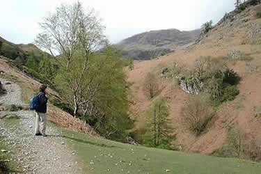
Click image to visit gallery of 6 images.
Wetherlam is often included as part of a horseshoe starting with Coniston Old Man or, from Little Langdale, in a circuit including Swirl How and Wet Side Edge. It is, however, a fine mountain in its own right and this Lake District walk of moderate length from the delightful hamlet of Tilberthwaite covers some varied terrain. The approach and the return are on excellent paths created by miners who worked the lower slopes hundreds of years ago and the impressive approach to the summit via Wetherlam Edge is in great contrast to the start and finish of the walk.
Leave the A593 Coniston to Skelwith Bridge road at Great Intake (GR 313996) just under 2 miles north of Coniston and take the minor road heading north west to Low Tilberthwaite which is reached after just under 1 mile. Park at the carpark (GR NY306010) just before the bridge over Tilberthwaite Gill.
Climb the steps leading out of the car park and join the miners track which climbs along side the south east (left) bank of the Gill. After passing various quarries and mine workings the path levels and a fork is reached. Fork right and follow the path as it drops down towards the footbridge crossing the Gill. The Gill is almost alpine in character with larch and rowan predominant. Cross the footbridge and climb steeply before turning left onto the path from the hamlet of Tilberthwaite. This path contours around the foot of the minor fell of Blake Rigg until it starts to climb steeply to Birk Fell Hause. At the Hause in clear weather there are excellent views down into Little Langdale and across to Blea Tarn and the Langdale fells.
At the Hause turn left onto a level path which steepens sharply as the ridge of Wetherlam Edge is reached. This is a surprisingly dramatic ridge, in complete contrast to the route so far. Several low rock steps have to be negotiated but nothing of any difficulty. In mist, follow the line of the ridge and the summit cairn is reached 100 yards after the ridge levels out.
Three routes meet at the summit. Our descent down Lad Stones Ridge heads due south for about 75 yards when it starts to veer to the left (south west) to follow the faint ridge line at an easy angle downwards. The ridge is not followed to its foot. After about half a mile it is possible to head further left and drop down to meet the miners track from Coppermines Valley to Tilberthwaite near Hole Rake (GR293991). Turn left onto the miners track and follow it back to Tilberthwaite. Before leaving, take the short walk along the road to Low Tilberthwaite. This is one of Lakeland's prettiest cottages with a barn and spinning gallery attached.
Other walks nearby
| Walk 1134 | Wetherlam and The Carrs | mod/hard | 10.8 miles |
| Walk 2270 | Tilberthwaite and Holme Fell Little Langdale | easy/mod | 5.5 miles |
| Walk 1144 | Lingmoor Fell | moderate | 8.0 miles |
| Walk 1171 | Pike o' Blisco | moderate | 5.0 miles |
| Walk 2582 | Pike o' Stickle, Harrison Stickle & Pavey Ark | moderate | 6.0 miles |
| Walk 3508 | The Crinkle Crags from Wrynose Pass | easy/mod | 5.0 miles |
| Walk 1217 | Dow Crag & the Old Man of Coniston | mod/hard | 8.5 miles |
| Walk 1761 | Tom Heights and Tarn Hows | easy/mod | 7.0 miles |
| Walk 3028 | Tarn Hows & Tom Gill | easy/mod | 6.5 miles |
| Walk 3220 | Wetherlam via Red Dell | moderate | 7.0 miles |
Recommended Books & eBooks
Walking the Lake District Fells - Mardale and the Far East
 Part of the Walking the Lake District Fells series, this guidebook covers a wide range of routes to 36 Lakeland summits that can be climbed from the Ullswater, Haweswater, Troutbeck, Kentmere and Longsleddale valleys, with highlights including High Street, Place Fell and the Kentmere fells. Suggestions for longer ridge routes are also included.
More information
Hadrian's Wall Path
 Hadrians Wall Path guidebook to walk the 84 mile National Trail. Described in both directions, the main description is west to east between Bowness-on-Solway and Wallsend, Newcastle, with extensions to Maryport and South Shields. With extensive historical information related to this World Heritage site and separate 1:25,000 OS map booklet included.
More information
Messaging & Social Media
Message Walking Britain and follow the latest news.

Mountain Weather
Stay safe on the mountains with detailed weather forecasts - for iOS devices or for Android devices.