Tower Ridge on Eel Crag returning via Sail & Barrow
Lake District Walk
Nat Park - Lake District - Lake District North Western Fells
Wainwrights - Barrow, Eel Crag, Outerside, Sail
County/Area - Cumbria
Author - John Paterson
Length - 6.3 miles / 10.2 km Ascent - 3000 feet / 909 metres
Time - 6 hours 10 minutes Grade - hard
Maps 

| Ordnance Survey Explorer OL4 | Sheet Map | 1:25k | BUY |
| Anquet OS Explorer OL4 | Digital Map | 1:25k | BUY |
| Ordnance Survey Landranger 90 | Sheet Map | 1:50k | BUY |
| Anquet OS Landranger 90 | Digital Map | 1:50k | BUY |
Walk Route Description
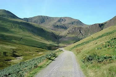
Click image to visit gallery of 9 images.
In his famous set of guide books, Wainwright discovered and described two routes on Eel Crag - the Shelf route and Tower Ridge, which he said were preferable to the loose scree route ascending from Coledale Hause. Both routes start at the same point on the north east face of Eel Crag and are clearly visible on the walk up Coledale from Braithwaite. Neither route has become popular but recent positive comment in the walking press (and this description!) may change all that. This is not a route to attempt in mist as finding the base of the ridge would be difficult without GPS.
Tower Ridge appears from Coledale (see picture 1 below) as a triangular rock feature just below the summit plateau of Eel Crag (named on the map as Crag Hill) and the route climbs the left edge of the rock feature. The shelf route (not fully described here) starts at base of the ridge and takes an upward traverse to the right to finish on the scree route above Coldale Hause. Note: Eel Crag is part of the famous Coledale round - extending from Grisedale Pike to Causey Pike. It is quite feasible to include both routes in the full circuit by taking the first part of the scree route from Coledale Hause then moving left and descending the shelf route before climbing Tower Ridge to the summit of plateau. I estimate that this would add an hour to the normal circuit.
To start this excellent lake District walk drive up the Whinlatter Pass for about 300 yards out of Braithwaite Village and park in a small quarry on your left. (GR NY227237) Take the mine road to Coledale guarded by a vehicle barrier.
Proceed along the almost level Coledale mine road for about 2 miles. Tower Ridge is visible on the north face of Eel Crag for most of the way. Just as Force Crag mine comes into view take the 4 x 4 track descending to the left and ford Coledale beck. Follow the track up the fellside until you reach the top of Low Force waterfall and the path levels out. (GR196212) A marshy depression will be seen to the left. Cross the marshy area below screes on the right keeping to the right bank of the stream until you reach the far end of the screes. (GR 195208) There is no distinct path at this point but you may see the odd small cairn. Once the screes have been avoided head up hill trending right above the screes. The ground becomes more rocky and you are on the foot of Tower Ridge. About 200 yards after leaving the scree behind, the ridge ahead becomes more defined (GR193207) and Wainwright's Shelf route will be seen traversing up at a gentle angle to your right.
The ridge ahead is interesting but what few difficulties there are can be avoided on faint paths to the left where the rock merges into the fellside. To the right the drops are much steeper. The scrambling is similar to Halls Fell Ridge on Blencathra but much less sustained. The views down Coledale and across to Grisedale Pike are stunning. All too quickly, after about 500 feet, the final rock tower is avoided by a steep grass path to the left and you will find yourself on the summit plateau. Turn left and cairns lead to the summit about 200 yards away.
From the summit head east across an airy ridge to the summit of Sail and then down a steep descent to Sail Pass. (Ahead lies the continuation of the Coledale Circuit over Scar Crags and Causey Pike) Our route turns left at the pass and down past the workings of a long abandoned Cobalt mine. When the path levels out on High Moss a small cairn (GR210213) marks the point where a faint path to the left leads over marshy ground to the slopes of Outerside after about 100 yards. Climb Outerside on a faint track. From the summit you will see the final part of the route. Ahead is Stile End (not a Wainwright) and, to its right, the pass of Barrow Door with the heather clad small fell of Barrow Beyond it. From Barrow an easy descent down good paths leads to Braithwaite village. It is about 300 yards to the car park with a possible detour to slake your thirst at the Coledale Inn.
Other walks nearby
| Walk 1155 | Causey Pike | moderate | 6.3 miles |
| Walk 2581 | Lord's Seat & Barf from Whinlatter | moderate | 8.5 miles |
| Walk 2041 | Barf (via the Bishop) and Lords Seat | mod/hard | 4.0 miles |
| Walk 2036 | Cat Bells from Gutherscale | easy/mod | 4.0 miles |
| Walk 3525 | Cat Bells (Route 2) | easy/mod | 4.0 miles |
| Walk 3119 | The Newlands Horseshoe - Catbells, Dale Head & Hindscarth | mod/hard | 12.0 miles |
| Walk 3029 | Derwentwater & Walla Crag | easy/mod | 6.5 miles |
| Walk 3037 | High Seat & Bleaberry Fell from Keswick | moderate | 9.0 miles |
| Walk 2321 | Shores of Derwentwater from Keswick | easy | 3.5 miles |
| Walk 1187 | Robinson & Hindscarth | mod/hard | 6.5 miles |
Recommended Books & eBooks
Walking the Lake District Fells - Mardale and the Far East
 Part of the Walking the Lake District Fells series, this guidebook covers a wide range of routes to 36 Lakeland summits that can be climbed from the Ullswater, Haweswater, Troutbeck, Kentmere and Longsleddale valleys, with highlights including High Street, Place Fell and the Kentmere fells. Suggestions for longer ridge routes are also included.
More information
Great Mountain Days in the Lake District
 An inspirational guidebook to 50 challenging walks on the high fells of the Lake District. The graded circular routes, between 4 and 14 miles in length, cover classic Lakeland summits like Fairfield, Scafell Pike, Great Gable and Blencathra, to the lesser-known High Spy, King's How and Brund Fell.
More information
Messaging & Social Media
Message Walking Britain and follow the latest news.

Mountain Weather
Stay safe on the mountains with detailed weather forecasts - for iOS devices or for Android devices.