Walk 2043 - printer friendly version
Thorney Island from Emsworth Walk
Author - Chichester Harbour Conservancy
Length - 9.0 miles / 14.6 km
Ascent - 100 feet / 30 metres
Grade - easy/mod
Start - OS grid reference SU749059
Lat 50.847782 + Long -0.93745128
Postcode PO10 7DB (approx. location only)
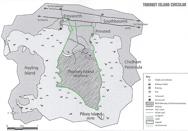
A walk along the shoreline of Chichester Harbour around the perimeter of Thorney Island with splendid views over the harbour. The starting point in Emsworth is at the village square (map ref. SU749059). Alternatively you may wish to drive and park in the small free parking area in the village of Prinsted (map ref. SU766051), signposted off the A286 east of Emsworth, and omit the extra mile to join the route to and from Emsworth.
Tide times - must be consulted as the route may be flooded in one or two places at very high spring tides. Phone the Harbour Office (01 243 51 2301) for information or see the Conservancy website. Special note - because a large part of the walk is on Ministry of Defence land you cannot take any short cut across Thorney Island. You must keep to the shoreline path.
START in Emsworth by locating yourself in the village centre (a triangle) facing the pub called The Round Table. Take the road ahead of you out of the centre (Queen Street), which shortly bears left and downhill. Follow this road until you reach the pub, The Lord Hag an, on your right. Just beyond this pub you will need to look for the footpath sign directing the route through some housing (it is not obvious - take care!). You will emerge on a path with a pond on your left and a small harbour inlet on your right.
Follow this path round two sides of the pond. When you reach the quiet road go straight over following the footpath sign between houses. The path will take you through to, and across, a field.
You will emerge onto the Thorney road. With care, cross straight over and to low the path which is quite narrow here, with a hedge on one side and a ditch on the other. The path will emerge onto a quiet road. Turn left and immediately right to carry on through the countryside. You will pass a couple of houses to your right and go into a field. Cross the field and then you will reach the village of Prinsted.
The path comes out onto a bend in a road. Do not turn left but bear right and straight down the road. It will then bear right and meet another road coming in from the left. Turn right and follow the road to meet the shoreline.
Walk up the embankment onto the shoreline. The shoreline path goes to the left and to the right take the route to the right, through a gate and along the shoreline. You will then reach two boatyards, Paynes and Thornham Marina. The path passes through both of these - take care on the stiles.
The route continues alongside the shoreline and comes out onto a raised embankment at Thornham Point on Thorney Island.
Continue to follow the path along the shoreline. You will walk over an oak bridge, which crosses the gap to allow tidal flooding of the saltmarsh to your right. The route bears round to the right and then you will meet a junction of two paths. Do not turn right but go left over the stile and along the straight path. Do not be put off by the tall gate ahead of you! You are approaching MOD land and will now need to stay on the path at all times.
Once you reach the gate, press the intercom buzzer. You will be answered by a guard manning the security gate from the gatehouse across the wetlands on the Thorney road. You will need to give your name and address now and again later, on the other side when you emerge from MOD land. You wil1 be reminded to keep to the shoreline path and then the guard will release the gate and you will be able to push the gate open and pass through.
Carry on the shoreline path. On this stretch it is very worn. Take great care. After about 1 mile you will reach a dinghy park on your right. Just beyond this you will find the path climbs up the bank with a few steps to go alongside the church.
This is the second and last point that may be flooded at very high spring tides - either wait or paddle!
Walkers were not allowed to stray off the path to explore the church and small war cemetery, however this seems to have changed according to reports received in early 2008. If you would like to see them, there is an opportunity to view the church and cemetery on the Conservancy's 3-day guided walk of the harbour in late spring and early autumn, contact Harbour Office for details.
Once past the church the footpath meets the road and you will see a sailing club straight ahead. If the tide allows you may bear left and follow the shoreline past the club and another club next to it.
If the tide is high you must turn right and then left into the car park, keeping to the left, and onto the path at the other end of the car park. The path turns left and returns to the shoreline. Turn right. Whichever route you take, both meet up here. Carry on along the path following the shoreline. After about half a mile the path becomes edged by hedging on both sides. Continue.
The path will eventually turn right. At this point you will have reached the southernmost tip of the island. You will see the sandy beach and dunes of Pilsey Island.
The path now travels in a north westerly direction, still following the shoreline, for nearly two miles. You will reach a point where the path and sea wall turns sharp right. This is Marker Point. This is a good spot for taking a break.
Now continue on the path which takes a rather loop-the- loop course following the shoreline. You will eventually reach the other security gate. Press the buzzer and give your name again over the intercom. The guard will release the gate for you to pass through. Ahead lies one mile of dead straight walking along the line of the old land-reclamation embankment. This is another good place from which to watch birds. You will then reach some distinctive black and white chalet houses on stilts. The path follows in front of them. When you pass through a small gate, turn right, following the track, which forms part of Emsworth Yacht Harbour. You will see the basin of the marina on your left.
When you reach the corner of the basin look for the signpost marking the route of the footpath in between some more chalet houses (on your right) and the basin (to your left). The route then bears left and then right through the boatyard activities. Look for the small gate ahead to leave the marina. A few yards ahead you will reach Slipper Mill Pond and the point where you left the Pond on your way out.
Retrace your route back into Emsworth.
This walk is reproduced courtesy of Chichester Harbour Conservancy and is one of ten walks presented in a clear plastic wallet with an overall map of the Harbour shoring footpaths, roads, train and bus stops. The route details contained in the printed leaflets are supplemented by background information (omitted in this transcript) on the area in which you are walking.
Messaging & Social Media
Message Walking Britain and follow the latest news.

Mountain Weather
Stay safe on the mountains with detailed weather forecasts - for iOS devices or for Android devices.