Walk 2055 - printer friendly version
Moel Emoel from near Bala Walk
Author - Ray Hind
Length - 6.0 miles / 9.8 km
Ascent - 1485 feet / 450 metres
Grade - moderate
Start - OS grid reference SH913384
Lat 52.931962 + Long -3.6186359
Postcode LL23 7SA (approx. location only)
A circular moderate walk of 9 ½km, to the north of Bala, over varied terrain including open moorland that takes around 3 ½ hours. There are good views of Bala town, Lake Bala (Llyn Tegid) and the surrounding mountains. The route is wet in some places and boots are recommended.
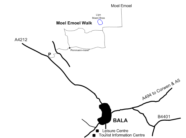
Start / Finish: A4212 near Pont Ty'n-y-ddol (SH913384)
Directions from Bala : Take the A4212 towards Frongoch and Trawsfynydd, after 1 ½ miles just after crossing the river (Tryweryn) park on the right where there is a short stretch of "dead" road.
The Walk : Take the tarmac road, signposted "Llwyber Cyhoeddus" after 100m turn-left (way-marked) and follow the farm access track, at the farm (Berth) follow the way-marked route behind the farm and into the field behind the farm. Go through a gap in the hedge/fence and up the field with the old hedge on the right, at the stile cross to the other side of the old hedge and continue up the field, past a ruin, to the fence. There are views of the Arenigs to the rear.
Cross the stile and turn left along the road, after 200m at the signpost, turn sharply right and follow the vehicle-track uphill and through woods. When the track peters out, continue ahead uphill along the field with the stream and woods on the left. Cross the fence at a stile and continue ahead in the same general direction as the overhead electric cables. Just before the derelict farm-house (Penmaen-mawr) turn left through a gate then immediately right to go behind the farm-house following a faint path, then through marshy ground continuing in the same direction and also that of the overhead electric cables. Moel Emoel can be seen to the left. Enter the wood at a stile and continue, in the same direction as the overhead electric cables, through the wood to exit at a stile, continue ahead on a vehicle track under the pylons and along the track past building on the left (Penmaen-canol). Ford the stream and enter woods via a stile to walk upstream with the stream on your left. After around 200m, fork right along the side of a small stream, this may be dry, and climb up to and over a stile hidden behind an oak tree. Continue along the field with the hedge on your left to go over a stile in the corner. Turn right and follow the fence/hedge, on your right, down to and over a stream, continue along the old hedge (way-marked), cross to the other side of the old hedge and continue along the old hedge under electricity supply cables; when the old hedge finishes continue uphill on a faint path. The path continues through an overgrown wood, which can be avoided by crossing the field (uphill) to the fence then turn left along the fence to a metal gate. Go through the gate and turn immediately left to enter woods at a gate/stile. From here there are views of Bala town, Lake Bala, Arans and Arenigs.
Continue through the wood along a gap in the trees on an "elevated" path, cross a stream and continue in the same general direction. Cross boggy ground to leave the woods at a stile, then continue ahead on a path through gorse bushes, uphill to and through a gate, then cross the un-surfaced road through a second gate. Continue ahead on a vehicle track, at the gate/stile leave the track and go onto open moorland. Moel Emoel is now ahead of you and Llyn Maen Bras to the left.
There is no clear path to the summit of Moel Emoel, however the summit direction is rather obvious. One route is to bear right and climb up to the south ridge parallel to the plantation (Coed Foel Emoel) which is now mainly cut-down. Upon gaining the south ridge follow it to the summit. From the summit there are views of the Berwyns, Bala town, Lake Bala, the Aran ridge, Arenig Fawr, Llyn Celyn, Arenig Fach and more. There are good views of Llyn Maen Bras on the descent.
From the summit you may return by the same route or another in the general direction of Llyn Maen Bras; leave the moorland at the same gate/stile as you entered and continue along the vehicle track to the un-surfaced forestry road, at this point turn right to follow the forestry road, first through a wood then a plantation (Coed Penmaen-mawr). Towards the end of the plantation, turn left at a waymarked post to descend to a walled lane, continue downhill and leave the plantation at a stile. The derelict farm-house (Penmaen-mawr) will be visible ahead and is on the return route. After crossing the stile turn left and go downhill with the old hedge on your right, continue downhill then over a stile through the field to the derelict farm-house. Then retrace your route to the start.
Information Notes: The River Tryweryn is supplied with water from Llyn Celyn and has hosted the world championships for canoe slalom and white-water racing as well as national and international competitions. The National White-water Centre (Canolfan Tryweryn) is a short distance further along the A4212. At the centre you can go white-water rafting or walk along the bank of the river up to the dam. The walk start point is also the finish for white-water races, so is best avoided if there is a race on.
Accommodation is available nearby at Abercelyn Country House.
Messaging & Social Media
Message Walking Britain and follow the latest news.

Mountain Weather
Stay safe on the mountains with detailed weather forecasts - for iOS devices or for Android devices.