Great Orme & Country Park, Llandudno (short route)
Conwy Walk
County/Area - Conwy
Author - Lou Johnson
Length - 4.0 miles / 6.5 km Ascent - 800 feet / 242 metres
Time - 2 hours 50 minutes Grade - easy/mod
Maps 

| Ordnance Survey Explorer OL17 | Sheet Map | 1:25k | BUY |
| Anquet OS Explorer OL17 | Digital Map | 1:25k | BUY |
| Ordnance Survey Landranger 115 | Sheet Map | 1:50k | BUY |
| Anquet OS Landranger 115 | Digital Map | 1:50k | BUY |
Walk Route Description
Click image to visit gallery of 6 images.
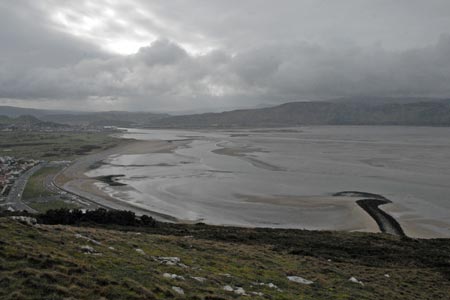
This route makes an excellent half day walk from Llandudno. The Great Orme offers some quite wild country in contrast to the crowds on the seafront. The Great Orme is prominent Limestone headland that rises to 207 metres above sea level with some wonderful views to be enjoyed in all directions including Llandudno and the coast, Conway with its fine castle and the mountains of Snowdonia (Eryri).
The start for this walk is Prince Edward Square (grid ref SH781826) towards the western end of Llandudno's promenade. From here walk along North Parade (with the sea to your right) towards the entrance to the pier. Before reaching the pier, turn left following the signs to the "Tram Station". Walk past the station and take the second small street on the right which leads you up to Cwlach Road. Turn left and continue through Haulfre Gardens to join the Invalids Walk, which is lined with benches donated by people that once enjoyed the view towards Conway and over Llandudno town.
You soon reach the start of a zig-zag path on your right. This is located just before a concrete shelter on the right and signed "Summit Trail Zig-Zag". The path climbs the steep hillside with the zig-zags making progress quite fast. Once on this trail stay on the main path and follow the clear signs and marker posts. The path levels for a short distance before climbing up a rocky step. The route continues in this fashion until sight of the summit comes in view. During the ascent a flock of wild goats were encountered. Do heed the warnings given on signs about feeding them.
You can take the direct route towards the trig point which marks the official summit of the Great Orme. However be careful crossing the tramway with its moving cable and trams. From here walk the short distance to the summit station and the café/pub alongside. Looking down towards the coast on the northern side of the Great orme you will see a church and a large cemetery. This is the next objective and is reached by following the marked path across grass that leads to the lane above St Tudno's church.
Walk down the lane towards the Church. Almost opposite is a footpath sign. Follow this and the marker posts. At the first junction (grid ref. SH771835) take the left fork. This leads to cottages. Stay on the marked route and this soon takes you the top of the dry ski run and toboggan track. Two options are available at this point. Either follow the stepped path down towards Llandudno or alternatively bear left and follow a grassy path towards the cliff tops. Quite soon you will be rewarded with a superb view of the Pier and the whole of the front at Llandudno. To continue bear right and rejoin the concrete path. Do be careful if you have young children as there are some steep drops on this option.
Once on the main path through Happy Valley descend through some pleasant rock gardens towards the sea and town centre. The route is well signed. Joining a tarmac road, turn right. This takes you down past the Grand Hotel back to the start on the main promenade.
Other walks nearby
| Walk 1435 | Sychnant Pass, Alltwen, Penmaen-Bach, & Conwy Mountain | easy/mod | 3.0 miles |
| Walk 3604 | Foel Lus & Jubilee Path from Sychnant Pass | easy/mod | 5.9 miles |
| Walk 2497 | Druid Circle, Moelfre and Foel Lus from Penmaenmawr | easy/mod | 6.0 miles |
| Walk 3061 | Eastern Carneddau from near Rowen | mod/hard | 10.5 miles |
| Walk 2547 | Carnedd Llewelyn from near Rowen | mod/hard | 12.0 miles |
| Walk 2346 | Yr Orsedd ridge from near Bont Newydd | moderate | 4.8 miles |
| Walk 3020 | Aber Falls, Foel-fras & Drum | mod/hard | 9.0 miles |
| Walk 3021 | Northern Carneddau | mod/hard | 12.0 miles |
| Walk 1635 | Garnedd Uchaf & Llyn Eigiau | mod/hard | 9.0 miles |
| Walk 2542 | Foel Grach & Llyn Eigiau | moderate | 8.5 miles |
Recommended Books & eBooks
The Cambrian Way
 Guidebook to the Cambrian Way, a challenging three-week mountain trek through Wales from Cardiff to Conwy. The 470km un-waymarked route is presented from south to north. Often sticking to long, beautiful ridgelines, it crosses wild and rugged terrain and visits many of Wales's highest mountains, including Snowdon.
More information
Snowdonia: 30 Low-level and easy walks - South
 Guidebook describing 30 walks in Snowdonia, Wales. Routes are mostly low level and on clear paths and showcase the region's beautiful scenery and rich history and culture. Part of a 2-volume set, this southern volume includes Trawsfynydd, Bala, Dolgellau, Machynlleth, the Harlech Coast and the valleys of the Mawddach and Dyfi.
More information
Messaging & Social Media
Message Walking Britain and follow the latest news.

Mountain Weather
Stay safe on the mountains with detailed weather forecasts - for iOS devices or for Android devices.