Stainborough Castle, Wentworth Castle & Worsbrough
South Yorkshire Walk
County/Area - South Yorkshire - Barnsley
Author - Andy Chaplin
Length - 8.9 miles / 14.5 km Ascent - 800 feet / 242 metres
Time - 5 hours 20 minutes Grade - easy/mod
Maps 

| Ordnance Survey Explorer OL1 | Sheet Map | 1:25k | BUY |
| Anquet OS Explorer OL1 | Digital Map | 1:25k | BUY |
| Ordnance Survey Landranger 110 | Sheet Map | 1:50k | BUY |
| Anquet OS Landranger 110 | Digital Map | 1:50k | BUY |
Walk Route Description
Click image to visit gallery of 3 images.
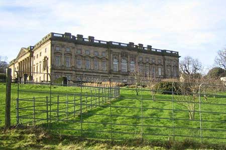
This is another walk in South Yorkshire that owes much to the Wentworth family for providing the backdrop that gives it a historical and architectural interest. In this case it is the Earls of Strafford rather than the branch of the family at Wentworth Woodhouse. Wentworth Castle and the Stainborough parkland provide the country estate interest and Worsbrough Reservoir provides the mill and canal interest. NOTE - sections of this walk cross Natioanl Trust property and an admission fee is payable.
Park in the Woodlands Trust car park at Bagger Wood (grid ref. SE302023) and walk on the track that leads north then east through the wood to the Bagger Wood Hill road. Go right into Hood Green and walk all the way through the village and then go right on Stainborough Lane and after 100m turn off left on the track into the Stainborough Park grounds. If the Bagger Wood car park is not open, then it is possible to park at National Trust car park at Wentworth Castle Gardens
Wentworth Castle is now a college and you have to pay to visit the Gardens but the parkland is free to roam. Follow tracks (from the Hood Green exit on the parkland map) all the way around the south of the gardens and castle until you get to the point where the deer park meets the road entrance to the gardens at grid ref. SE321034 (point 1 on the map) then take the parkland path towards the Serpentine bridge and carry on out of the park and past the Strafford Arms Hotel (Stainborough village exit).
Follow Park drive down to the main road, cross over and continue on Gilroyd Lane as far as the entrance to the industrial estate. From here there is a lane to the Trans Pennine Trail - Dove Valley Trail that crosses the M1 and continues on to Worsbrough Reservoir. As you approach the reservoir there is a path that goes down to the waterside and then crosses the dam side and comes out at the Mill Pond. Continue along the south side of the reservoir then turn right on a track that is called Doe Lane and continues across fields back towards the M1.
Cross the M1 on Old Hall Road and stay on it to Rockley Lane where you go right then take the "private" drive towards the Queen Anne Monument. Pick up the path through the gate to your left just before the house and follow it past Ivas Wood, Raven Holt Wood and through Broom Royd Wood. When you come out on a lane with a gate to your right that goes back into the Stainborough Parkland (Rockley & caravan site exit on the parkland map) go left across the fields to a footbridge over the Rockley Dike. Follow the path which skirts Green Springs Plantation and leads to Hermit Hill Lane. (Note there is a track through Green Springs Plantation. This NOT a right of Way.)
Go right on the lane past Hermit Hill Farm then take the path on the right that heads across fields to Cliffe Farm. Keep to the west of the farm, cross the arm track then bear off left across the fields to Gudgeon Hole Lane (is there another such named in the country?). Go straight across and up Dane's Lane then off on the right around the water treatment works. There is a clear path across the fields back to Bagger Wood Road which at the top part is a country lane that can become churned by the horses that are stabled and grazing nearby.
Other walks nearby
| Walk 2238 | Thurgoland Boundary Walk Oxspring | easy/mod | 8.6 miles |
| Walk 1545 | Wortley circular including Wharncliffe Crags | easy/mod | 8.1 miles |
| Walk 2825 | Silkstone Circular & Cannon Hall Country Park | moderate | 10.4 miles |
| Walk 2328 | Penistone to Shepley linear | easy/mod | 8.0 miles |
| Walk 1582 | More Hall Reservoir | easy | 3.4 miles |
| Walk 2726 | Penistone Circular from Scout Dike Reservoir | moderate | 8.3 miles |
| Walk 1935 | Birley Edge & Wharncliffe Wood | easy/mod | 9.4 miles |
| Walk 3439 | High Bradfield from Glen Howe | moderate | 8.3 miles |
| Walk 1523 | Broomhead Moor & Ewden Beck | easy/mod | 6.0 miles |
| Walk 2717 | Wentworth Woodhouse and its follies | easy/mod | 7.5 miles |
Recommended Books & eBooks
No suggestions for this area.Messaging & Social Media
Message Walking Britain and follow the latest news.

Mountain Weather
Stay safe on the mountains with detailed weather forecasts - for iOS devices or for Android devices.