Walk 2089 - printer friendly version
College Edge & Cuthbert's Currick from Edmundbyers Walk
Author - Lou Johnson
Length - 8.0 miles / 13 km
Ascent - 700 feet / 212 metres
Grade - easy/mod
Start - OS grid reference NZ013497
Lat 54.8421140 + Long -1.9812834
Postcode DH8 9NG (approx. location only)
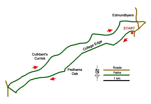
This County Durham walk explores the higher land to the north of the valley containing the Burnhope Burn to the west of the village of Edmundbyers. The most convenient place to start is the small parking area on the north side of the B6278 at the western end of Edmundbyers village (grid ref. NZ013497).
Go through the gate onto track by the parking area. Continue along this track in a westerly direction with the wall to your immediate left and the slopes of Limerick Edge to your right to reach Swandale (grid ref. NZ005491). Cross the stream and head steeply uphill to the right past some ruined buildings. At the wall corner (grid ref. NZ002492), bear left and follow a clear track beside the wall on your left. Stay on this track along College Edge to reach ruined Pedam's Oak farm (grid ref. NY987483) where you pass to the left of the barn into the yard.
Exit the farm yard through double gates and stay on a clear moorland track to the next Objective, the ruins at Belmont. This section of easy walking provides excellent views down into the Burnhope Burn valley to your left. From Belmont, the track continues westwards. Reaching a wall corner (grid ref. NY967474) and a junction of tracks, turn right and walk up to a road (grid ref. NY963475).
Turn right off the road and take the track which initially heads north before veering east. Leave the track at a small cairn and follow a narrow path to reach a gate (grid ref. NY970480). The route continues across the moor to another gate (grid ref. NY978474) and continues to just south of Cuthberts Currick from where great views to the north can be enjoyed.
The onward route follows the track to cross a stream a Swandale Head (grid ref. NY997496). The track continues alongside a walled enclosure on your left, fords Black Burn and then descends to the B6306 on the north side of Edmundbyers. Reaching this road, turn right and bear right off the B6306 down Church Lane. Follow this side road downhill to the B6278. Turn right and follow this road back to the start.
Messaging & Social Media
Message Walking Britain and follow the latest news.

Mountain Weather
Stay safe on the mountains with detailed weather forecasts - for iOS devices or for Android devices.