Ben Nevis via Carn Mor Dearg arete from Glen Nevis
Highland Walk
County/Area - Highland - Fort William Lochaber
Author - Lee Robertshaw
Length - 10.5 miles / 17.1 km Ascent - 5300 feet / 1606 metres
Time - 10 hours 30 minutes Grade - hard
Maps 

| Ordnance Survey Explorer 392 | Sheet Map | 1:25k | BUY |
| Anquet OS Explorer 392 | Digital Map | 1:25k | BUY |
| Ordnance Survey Landranger 41 | Sheet Map | 1:50k | BUY |
| Anquet OS Landranger 41 | Digital Map | 1:50k | BUY |
Walk Route Description
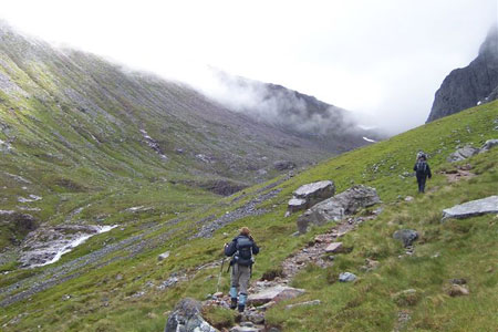
Click image to visit gallery of 6 images.
I've done this walk a couple of times now and although it really is a tough slog up the flank of Carn Mor Dearg, the view (weather permitting!) of the Bens north east face as you walk up the coire with the CMD arete looming closer and closer is really worth the effort. Once on Carn Mor Dearg summit the views of the arete and the Mamores range to the south are truly breathtaking. The Ben is a very confusing place in poor weather so you should make sure you take a map and compass - and know how to use them!
The start is the visitors centre car park (grid ref. NN124731) reached by following the signs for Glen Nevis from Fort William). From the car park cross the bridge over the river Nevis at the north end of the car park, turn right and follow a signposted path which leads to the track that starts at Achintee farm. Walk uphill on the track which is hard to get lost on, it's by far the most travelled path on the mountain. The grade isn't too taxing initially, but it starts to steepen and zigzag after a kilometre or so. It's worth taking it easy on this initial section and conserving your energy for what follows. The path climbs in a steep curve above Red Burn before easing off at the saddle holding Lochan Meall an t-Suidhe.
Lochan Meall an t-Suidhe is often dubbed 'the halfway Lochan' and marks the spot where the track splits. Where the path turns sharp right to start climbing again, take the left fork to head northwards (grid ref. NN147724) and follow it, keeping on the right-hand part when the track splits again after a few hundred metres, basically staying on the higher path. Follow the path round into the corrie as it tracks beneath the cliffs with the Allt a' Mhuilinn river down to your left, pass the 'luncheon boulder' on the left and continue as it climbs up to the CIC Hut- visible long before you get to it thanks to its wind generator.
From the CIC Hut (grid ref. NN167723), you can now take a direct line in an easterly direction up the bouldery flank of Carn Mor Dearg. There are the odd scratchings of lines of travel now and again, but broadly speaking this is very steep and sometimes loose ground that demands caution. Aim to join the ridge a couple of hundred metres north of Carn Mor Dearg's summit, and be very careful not to continue too far east: there are steep drops off the east of this ridge. This ridge is fairly well travelled with fantastic views to the east of Aonach Mor and Aonach Beag, and a short walk along it in a southerly direction should bring you to the top of Carn Mor Dearg -Scotland's ninth highest mountain.
From the summit of Carn Mor Dearg (grid ref NN178721), to begin its namesake arete you need to drop SSW down a rocky crest which soon levels into a bouldery ridge. High winds are a problem here, so be very careful. Technically, the arete barely merits scrambling Grade 1, slung high above Coire Leis in a slightly bowing slack-line, gently climbing to a pointy apex. After this it shifts direction slightly to SW and climbs towards the shoulder of The Ben, rough blocks of granite give good grip and the few exposed places can be easily circumvented on faint traversing paths.
Once on the final, bouldery ascent, stay well to the left of some marker poles on your right hand side to avoid the cliffs. There is no clear path up the boulder field and the summit arrives suddenly as the slope eases off. A cluster of cairns appears and then the trig point can be seen on top of a large well built cairn.
The summit of Ben Nevis (grid ref. NN166712) can be confusing and dangerous, due to featureless terrain and the presence of several sheer gullies on both sides of the plateau. If the weather is good you can easily follow the path and a line of cairns that pass close to the edge of the gullies on your right and follow this down to the zigzags. However, if visibility is very bad and particularly if there's snow on the ground, from the trig point walk 150m on a bearing of 231 degrees grid to safely skirt Gardyloo Gully. You then need to turn to a bearing of 282 degrees grid, which you need to follow carefully for over a kilometre, until you are sure you are safely established on the Pony Track, paying close attention to the almost invisible threat of Five Finger Gully to the left as well as the hazards to the right. The Pony Track then zigzags down the west flank, crossing the ford at Red Burn and soon you will find yourself at the junction where you left the Pony Track. From here, retrace your earlier steps back to the car park.
Other walks nearby
| Walk 3270 | Ben Nevis | mod/hard | 9.7 miles |
| Walk 1338 | Ben Nevis Tourist Path | mod/hard | 8.7 miles |
| Walk 3066 | Carn Mor Dearg (via Allt a' Mhuilinn trail) | mod/hard | 8.7 miles |
| Walk 3303 | Mamores Ridge - Stob Ban, Am Bodach and Sgurr an Iubhair | hard | 9.0 miles |
| Walk 3095 | Stob Ban (Mamores) | mod/hard | 6.0 miles |
| Walk 2918 | Aonach Mor and Aonach Beag - two of the "Lochaber giants" | mod/hard | 9.0 miles |
| Walk 3106 | Binnein Mor from Kinlochleven | hard | 10.2 miles |
| Walk 1039 | Am Bodach and Stob Coire a' Chairn | mod/hard | 9.5 miles |
| Walk 1094 | Blackwater Reservoir | moderate | 11.5 miles |
| Walk 1496 | WHW - Day 6 - Kinlocheven to Fort William | moderate | 15.0 miles |
Recommended Books & eBooks
Great Mountain Days in Scotland
 Inspirational guidebook to 50 challenging routes for mountaineers, scramblers, hillwalkers and fell runners, many long enough to backpack over 2 days, especially in winter (12 to 25 miles). A mix of classic routes and unsung gems across Scotland from Galloway to the Outer Hebrides in widely differing wild landscapes. With customised OS mapping.
More information
Walking in Torridon
 This guidebook contains 52 day walks in Torridon, a remote and much-loved area of the Scottish Highlands. Based around Shieldaig and Slioch, the routes are split into 3 sections: easy walks, long and high level walks and mountain ascents over 2000ft including 9 Munros, and 5 outline suggestions for major ridge walks.
More information
Messaging & Social Media
Message Walking Britain and follow the latest news.

Mountain Weather
Stay safe on the mountains with detailed weather forecasts - for iOS devices or for Android devices.