Upper Beeding to Washington by the South Downs Way
South Downs Walk
Nat Park - South Downs
County/Area - West Sussex
Author - Jean Blemings
Length - 7.0 miles / 11.4 km Ascent - 800 feet / 242 metres
Time - 4 hours 20 minutes Grade - easy/mod
Maps 

| Ordnance Survey Explorer OL10 | Sheet Map | 1:25k | BUY |
| Anquet OS Explorer OL10 | Digital Map | 1:25k | BUY |
| Ordnance Survey Explorer OL11 | Sheet Map | 1:25k | BUY |
| Anquet OS Explorer OL11 | Digital Map | 1:25k | BUY |
| Ordnance Survey Landranger 198 | Sheet Map | 1:50k | BUY |
| Anquet OS Landranger 198 | Digital Map | 1:50k | BUY |
Walk Route Description
Click image to visit gallery of 12 images.
This is a stretch of the South Downs Way that can easily be started from the car parking area (grid ref. TQ197094) to the west side of the A283 between Shoreham and Steyning. It is also served by the no. 2/2A bus service that runs between Brighton & Steyning.
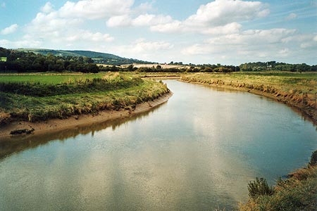
From the car parking area take the path signposted as the South Downs Way (SDW) down toward the river. As the path swings round to the right there is a handy drinking tap and horse trough if you or any dogs or horses you may have with you that are feeling thirsty. Cross over the river using the metal bridge. After the bridge bear right to walk along the river for a very short way before bearing left away from the river. Shortly after, you come to a crossing of tracks where the Downslink cycleway cuts across the path. The Downslink broadly follows the track of an old disused railway line from Shoreham right up to St Martha's hill near Guildford where it connects with the North Downs Way.
However our way is straight on crossing the Downslink to emerge onto a road. You may wish to take a short diversion off to the left to explore St Botolphs Saxon church glimpsed across the fields from the river after crossing the bridge at the start of the walk. To continue, carry on up the road ahead using the roadside path, which may be muddy in wet weather. Continue past a picturesque collection of farm buildings and cottages most including the name of Annington in their titles. As the road rises up, becomes shady and bears to the right make sure you do not miss the stony track signposted off to the left (grid ref TQ186095) along which the route of the SDW continues to climb. Pass a footpath off to the left and the isolated white-washed house. The track goes through a gate and climbs up out of the woods into more open arable farmland. Simply follow the stony chalk track as it climbs and eventually levels out. If you turn to look backwards you will see how the Beeding cement works has eaten back into the hills of the opposite side of the Adur valley.
Eventually you reach another gateway which leads into a huge open field, which as the ground is still gently rising you cannot see the end of. Maintain the same general direction over the field and eventually you will come to the right angled corner of some fencing. Start to follow the fence line onward in the same direction with the majestic natural amphitheatre of Steyning Bowl to your right and the bulk of Annington barn further up the rising ground on your left. There may be para-gliders or hang-gliders in Steyning bowl and model aircraft flying over the ground to the left so this can be a busy stretch of downland. Ahead you will see the scenic downland road that runs over the hills from Sompting to Steyning and eventually you come to the end of this huge field at the side of this road. Do not exit out onto the road but look for a gate to your right and pass through to walk alongside the side of the adjoining field parallel to the road. This is beautiful open downland and with much of the climbing out of the way fairly easy walking with a chance to look about and enjoy the views over to the Iron Age hill fort of Cissbury Ring visible off to the southwest.
Continue to walk along the field path provided running alongside the road passing through another gate way. When the path comes to an end follow the signposts to cross carefully over the road and through a gap in the fencing on the other side before picking up an old metalled track proceeding in a similar direction to the path you have just left still rising up gently to the crest of the hills. At the end of this track you come to complex junction of paths by the site of a touching memorial to a downland farmer and his wife. As you have been climbing pretty steadily now for the last few miles this is a wonderful spot to rest awhile and drink in the wonderful views all around and gather your energies for the way ahead.
Thus refreshed look for the SDW marker that signs your onward route. Taking the broad track indicated, journey onward passing a lonely trig point on your left. I have to confess the next mile or so are one of my least favourite stretches of the South Downs Way as you are some distance away from the scarp slope to your right marked by a wooded treelike and although there are views of Cissbury Ring again at times off to the left for a mile or so there is little to do but follow the track ever onwards. Your rewards for your endeavours however is soon at hand as ignoring paths that join the SDW from both sides you eventually reach another gate and cattle grid from which you catch your first sight of Chanctonbury Ring. This is another hill fort site and the remains of a Roman temple also have been found on the summit. Before the 1987 storm the summit had a crown of trees which are slowly regenerating but the summit still has a magical air about it and you may wish to linger here awhile and explore the gnarled trees and surrounding area.
To continue the walk, follow the track onwards passing to the south of the wooded summit. Off to the right you will then see the actual trig point of Chanctonbury hill which is worth a diversion to savour the fact that Chanctonbury is a Marilyn (a hill or mountain with a relative height of at least 150m or 492 ft regardless of absolute height).
Reverting back to the track onwards as you pass through another gate off to the right is a restored dew pond - quite a pretty one of its type. Once you have broken free of all these distractions and returned to the main route continue onwards but take care to look for the SDW marker directing you off to the right (Grid ref TQ130117) whilst the main track continues onwards as it is easy to go wrong at this point.
Once on the correct track, the way ahead is again clear dropping steadily downwards on a broad track. Eventually you come to a parking area which you pass through exiting on the access road of the car park, which you then follow right down to the side of the busy A24 which marks the end of this particular section of our walk along the SDW.
Now you can either risk a dash across the A road to continue onwards along the direct route of the SDW with your next staging point being Amberley seven miles or so distant with rail links available from there along the Arun valley connecting to London or the south coast line.
If you want to walk into Washington to catch the rather infrequent bus service back to Worthing or to refresh yourself in The Frankland Arms pub turn right to follow the quieter road that runs parallel to the A24. This leads into the village (as signposted) or if you bear off to the left a safer footbridge crossing of the A24 where you can rejoin the SDW heading onwards to Amberley. There are no direct public transport links to return you directly to the start of the walk although a taxi may be ordered from Worthing.
Other walks nearby
| Walk 1782 | Steyning Round Hill and No Man's Land | moderate | 7.5 miles |
| Walk 1858 | Cissbury Ring and Chanctonbury Ring | moderate | 10.5 miles |
| Walk 1888 | Cissbury Ring, Chanctonbury Ring & Coombes | moderate | 12.5 miles |
| Walk 1983 | Edburton Hill from Fulking | easy/mod | 6.1 miles |
| Walk 3488 | Devil's Dyke Circular | easy | 2.5 miles |
| Walk 3487 | Edburton Hill & Devil's Dyke from Saddlescombe | hard | 10.5 miles |
| Walk 3078 | Cissbury Ring & Chanctonbury Ring from Washington | easy/mod | 8.3 miles |
| Walk 3310 | Washington to Littleton Farm by the South Downs Way | moderate | 13.0 miles |
| Walk 3213 | Pyecombe, Devil's Dyke & Upper Beeding | easy/mod | 8.0 miles |
| Walk 2236 | Wolstonbury Hill and Pyecombe from Patcham | moderate | 11.0 miles |
Recommended Books & eBooks
Walks in the South Downs National Park
 Guidebook with 40 circular walks throughout the South Downs National Park, exploring the beautiful chalk hills between Eastbourne and Winchester. The walks range from under 5 miles to 11 miles, including Beachy Head and the Seven Sisters, Ditchling Beacon and hundreds of prehistoric sites. Accessible all year, but wild flowers best in spring.
More information
The South Downs Way
 Guidebook to walking the South Downs Way National Trail, a 100 mile (160km) route between Winchester and Eastbourne through the South Downs National Park, described in both directions over 12 stages. Easy walking on ancient and historical tracks, taking in wooded areas, delightful river valleys and pretty villages. With 1:25K OS map booklet.
More information
Messaging & Social Media
Message Walking Britain and follow the latest news.

Mountain Weather
Stay safe on the mountains with detailed weather forecasts - for iOS devices or for Android devices.