Upper Beeding to Washington by the South Downs Way Walk
Walk 2109 - Route Maps
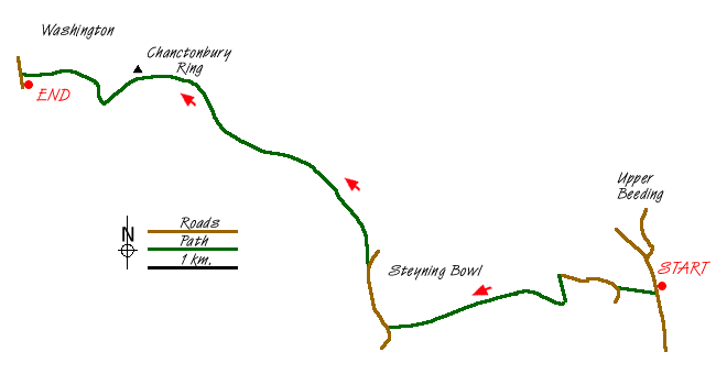
Route Map
Digital Maps - Copyright © 2011-2024. All rights reserved.
Sketch Map
Suggested Maps 

| Ordnance Survey Explorer OL10 | Sheet Map | 1:25k | BUY |
| Anquet OS Explorer OL10 | Digital Map | 1:25k | BUY |
| Ordnance Survey Explorer OL11 | Sheet Map | 1:25k | BUY |
| Anquet OS Explorer OL11 | Digital Map | 1:25k | BUY |
| Ordnance Survey Landranger 198 | Sheet Map | 1:50k | BUY |
| Anquet OS Landranger 198 | Digital Map | 1:50k | BUY |
It is recommended you take a map. The preferred scale is 1:25k.
Start Point Details
Ordnance Survey Grid Ref TQ197094
Latitude 50.871716 Longitude -0.300189
Postcode BN44 3TU
what3words start lamppost.units.groom
Walk description may contain detailed information on the start point for this walk.
Further Information
South Downs
The South Downs is Britain's newest National Park and stretches from Winchester to Beachy Head. Steeped in history there are ancient hill-forts, barrows, a Roman road and deserted medieval villages. The area has a rich diversity of natural habitats including flower-studded chalk grassland, ancient woodland, flood meadow, lowland heath and the particularly rare chalk heathland. This varied environment provides an excellent basis for those who enjoy outdoor pursuits, such as walking, cycling and horse riding. South Downs Walking Guide
West Sussex
West Sussex lies in Southern England and offers a variety of scenic interest including Wealden, downland and coastal. The highest point of the county is Blackdown, at 280 metres (919 ft). Over half of West Sussex is protected countryside including part of the South Downs National Park and the Chichester Harbour National Landscape (formerly AONB). The most important long-distance footpath is the South Downs Way National Trail.
Walk grading - Learn how each walk is assessed and select a walk to suit your ability and experience by going to Walk Grading Details.
Messaging & Social Media
Message Walking Britain and follow the latest news.

Mountain Weather
Stay safe on the mountains with detailed weather forecasts - for iOS devices or for Android devices.