Walk 2110 - printer friendly version
Ash Valley Circular Walk
Author - Donald Morton
Length - 5.5 miles / 8.9 km
Ascent - 300 feet / 91 metres
Grade - easy
Start - OS grid reference TL428193
Lat 51.854029 + Long 0.072003663
Postcode SG10 6BU (approx. location only)
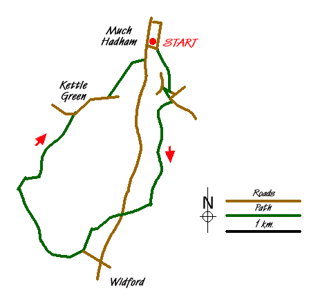
Much Hadham is a long village spreading down the B1004 which runs from Ware to Bishops Stortford. The Hertfordshire Way includes a detour to visit it and it does indeed have a wonderful variety of domestic architecture as well as a small museum (reopened March 2009 - Fridays, Saturdays, Sundays, Bank Holiday Mondays) itself in an interesting old house.
To find the car park in Much Hadham turn down the lane opposite the Bull PH (Grid Ref TL 428193) - or park in the High Street (B1004). If you have not previously visited Much Hadham it is recommended that you start the walk by going back to the B1004 and join the Hertfordshire Way Loop by turning right and walking up the High Street, which provides an opportunity to look at the houses of all sorts of styles, periods and social status - until the late 19th Century people seem to have lived much less segregated by social class. Turn right down a lane signed, on the left, to the church - if you visit the church you will see a most wonderful collection of some 200 hassocks created by the ladies of the parish. At the church turn right past Glebe Cottage and continue down the lane until arriving at a bend by Two Bridges. Leave the road by going straight on through a kissing gate. (If you want to miss out the loop through the village, on leaving the car park, continue down the lane from the Bull PH and just before the left bend you will find the kissing gate on the right.) Take the path to the left which goes between garden and field, over a bridge, half right across a meadow, across a drive, and across a water meadow, through a kissing gate and slightly right across a second meadow to a road (grid ref. TL431186).
At the road turn right to the ford. Just before the ford turn left through a kissing gate and up across the field to come out again on the road. Go straight on up the road and in a short distance turn right on Public Bridleway 28 and follow it along the edge of Sidehill Woods (the welcoming notice promises the seasonal beauty of bluebells among the coppiced trees). On exiting the woods the way continues as an enclosed track. Quite soon it goes through a bridle gate on the left and continues on the same line. After another gate it goes over a crossing path and down an enclosed track. It passes through Mill Wood and emerges into a new plantation (and, until this has matured, a patch of teasels at one time essential for finishing woollen cloth and now most useful for amusing small children when one sticks to Daddy's back). Soon a concrete track is reached. Turn right to reach a lane. Again turn right.
Cross the B1004 (grid ref. TL424168) and continue on the bridleway. This parallels the B road for a few yards and then turns right along the field edge, hedge right. Pass an industrial compound to reach a concrete access road. Turn right and at the end go over a crossing track and down an enclosed bridleway. At a cross path turn right through a metal kissing gate and along the edge of a field to a bridge over the Ash. Turn left to a way mark where you fork right to a hedge gap (grid ref. TL414163). The path dog legs left and right to go up hill through another wide hedge gap.
At a three way junction take the right hand path which leads up a field edge and then across cultivated land to a footpath running between hedges. (Note that there is some doubt about the defined right of way which is being investigated by the County Council: the marked route could be subject to change.) Having passed a house and some farm buildings the way continues on concrete strips to Little Blakesware, an elegant looking house which can just be glimpsed to the right through more utilitarian farm buildings. Continue straight on now going over the open Hertfordshire uplands providing wide views on all sides. As it approaches woods it goes along a field edge - hedge left - and then at the woods turns right to go along the outside edge. It turns left at the corner of the woods, still following the edge and then where the woods end (grid ref. TL 412177) continues slightly right on an unploughed grass strip to a path junction at the corner of a hedge.
Take the left hand route to arrive at Kettle Green, with its moated farmhouse. Dog leg right/left between the buildings and arrive at a lane. Turn right (effectively straight on) and follow the lane until crossing footpaths (grid ref. TL 422185). Turn left up steps on Public Footpath 11 Tower Hill. This skirts a house to a gate leading out to a drive. Cross over and head half right over the meadow to a stile and gate to the left of all the buildings. Continue the same line to a second stile from where there is a fine view of Moor Place. Again continue the previous line across the parkland in front of the house to a stile in the corner. On the other side go right down the drive and exit the park through lodge gates into Much Hadham High Street (grid ref. TL427191). The start car park is to the left and down the lane opposite the Bull.
Messaging & Social Media
Message Walking Britain and follow the latest news.

Mountain Weather
Stay safe on the mountains with detailed weather forecasts - for iOS devices or for Android devices.