Camps Reservoir Circular
South Lanarkshire Walk
County/Area - South Lanarkshire
Author - Lou Johnson
Length - 5.8 miles / 9.4 km Ascent - 600 feet / 182 metres
Time - 3 hours 30 minutes Grade - easy
Maps 

| Ordnance Survey Explorer 329 | Sheet Map | 1:25k | BUY |
| Anquet OS Explorer 329 | Digital Map | 1:25k | BUY |
| Ordnance Survey Explorer 330 | Sheet Map | 1:25k | BUY |
| Anquet OS Explorer 330 | Digital Map | 1:25k | BUY |
Walk Route Description
Click image to see photo description.
This pleasant un-demanding walk in South Lanakarkshire offers quiet, easy walking with lovely views of the surrounding hills. The route offers solitude and excellent exercise. The start is reached from the village of Crawford on the A702 reached from junction 14 of the M74 motorway. To reach the reservoir exit the village on the minor road to the 'Reservoir'. As you approach the dam keep right where the road forks and park on the grass verge (grid ref. NS993224).
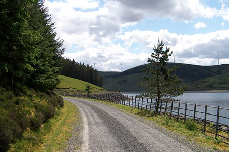
After parking walk up the road, cross the cattle grid and continue through a gate. Turn right across the dam and reaching the other side bear right following the track around the reservoir. Few other directions are necessary and you walk along the shore of the reservoir enjoying the views. For most walkers who wish to take in the scenery and maybe take time out for a rest then three hours should be sufficient.
Other walks nearby
| Walk 3752 | Tinto from Wiston (southern approach) | moderate | 4.2 miles |
| Walk 2268 | Annandale Way | moderate | 9.0 miles |
| Walk 2050 | The Crown of Scotland | moderate | 9.0 miles |
| Walk 3751 | Tinto (northern approach) | moderate | 4.5 miles |
| Walk 2035 | Hart Fell via Hartfell Spa | moderate | 7.2 miles |
| Walk 2280 | Hart Fell & Whitehope Heights | moderate | 8.4 miles |
| Walk 2618 | Broad Law & Megget Stone | moderate | 5.0 miles |
| Walk 3294 | Trahenna Hill from Broughton | moderate | 7.1 miles |
| Walk 2008 | Hart Fell via Saddle Yoke & the Black Hope Horseshoe | mod/hard | 8.5 miles |
| Walk 2045 | Capel Fell via Sailfoot Law & Broken Back Hill | moderate | 5.8 miles |
Recommended Books & eBooks
No suggestions for this area.Messaging & Social Media
Message Walking Britain and follow the latest news.

Mountain Weather
Stay safe on the mountains with detailed weather forecasts - for iOS devices or for Android devices.