Walk 2210 - printer friendly version
Holly Hill & Coldrum Long Barrow Walk
Author - Mick Gall
Length - 5.0 miles / 8.1 km
Ascent - 700 feet / 212 metres
Grade - easy/mod
Start - OS grid reference TQ669629
Lat 51.340687 + Long 0.39480891
Postcode DA13 0UB (approx. location only)
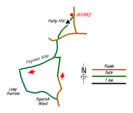
This circular walk starts and finishes in the car park/picnic area at Holly Hill (grid ref. TQ669629). The route includes woodland, a section of the Pilgrims Way and a visit to the Coldrum Long Barrow, a 5000 year old burial chamber.
From the car park at TQ 670 629 take the steps straight in front and follow the path for 300m to the top of Holly Hill. There is a trig point here and a small picnic area. At 196 m. above sea level, this is one of highest points in Kent. On a clear day the distant Canary Wharf in London can be seen. After enjoying the view follow the path down the opposite side of the hill through Holly Wood until you come to a path junction. Take the left hand path and follow it down to White Horse Road (grid ref. TQ665622).
Cross the road and continue to follow the path through White Horse Wood. The path descends steeply and care needs to be taken as there is a lot of water erosion on parts of this path that makes a deep gully down the middle of it. This path joins the Pilgrims Way/North Downs Way at a path junction (grid ref. TQ 663616). Turn right here and follow the National Trail west. This path descends gradually and gives good views over the Medway Valley and the Weald of Kent. At the cross-roads at grid ref. TQ652612 turn left. It is sign-posted Coldrum Long Barrow.
After approx 500m the long barrow is reached at grid ref. TQ654607. This is a long barrow burial chamber and is believed to have been constructed around 3000BC. It consists of standing stones at the front and laying stones in a semi-circle that made up the side of the barrow. Ribbons and offerings are tied to the branches of some of the trees.
Leave the stones and continue along the path to another junction at grid ref. TQ654605. Take the left-hand path through Ryarsh Wood. Follow the path until you come to a tarmac road (grid ref. TQ664603). Turn left along the road.
Follow the road until you come to Park Farm (grid ref. TQ664611). There are three paths here, take the middle one, which is easy to spot. This path is tree lined and gently goes uphill to the Pilgrims Way/North Downs Way at TQ 665616. Turn left and continue back to the path junction passed earlier at grid ref. TQ663616. Turn right and follow the path back the way you came to the car park. This path is steep and can be quite tricky in places especially after rain.
Messaging & Social Media
Message Walking Britain and follow the latest news.

Mountain Weather
Stay safe on the mountains with detailed weather forecasts - for iOS devices or for Android devices.