Slaidburn Village Trail - Ribble Valley
Forest of Bowland Walk
Region - Forest of Bowland
County/Area - Lancashire
Author - Ribble Valley Borough Council
Length - 0.8 miles / 1.2 km
Ascent - nominal or unknown
Time - 0 hours 20 minutes Grade - easy
Maps 

| Ordnance Survey Explorer OL41 | Sheet Map | 1:25k | BUY |
| Anquet OS Explorer OL41 | Digital Map | 1:25k | BUY |
Walk Route Description
Click image to visit gallery of 2 images.
There has been a settlement at Slaidburn since at least Anglo-Saxon times, when the name (which means 'stream by the sheep pasture) was given to the area near the junction of the River Hodder and Croasdale Beck. Following the Norman Conquest, the village became an administrative centre for the Forest of Bowland, with its own court to deal with minor disputes. Although part of the Duchy of Lancaster, Slaidburn was, until 1974, in the West Riding of Yorkshire. After that time, it was incorporated into Lancashire and now lies at the centre of the Forest of Bowland Area of Outstanding Natural Beauty.
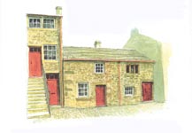
The History - Slaidburn is unusual in that much of it is controlled by the King-Wilkinson family, which has owned most of the village since the late 19th century This has ensured that a wealth of vernacular building has survived intact and also that the village has not suffered from development around its fringes.
Most of the houses date from the 18th and 19th centuries and are built either from sandstone quarried on Waddington Fell, or from a mix of sandstone and local limestone. Where limestone has been used, the walls are often rendered with stucco to disguise the poor quality of the building material.
There are one or two surviving carved doorheads in the village dating from the 17th century, as well as mullion windows from the same period, but most buildings feature plain, square-cut lintels and jambs of a later date. The exception to this is Brennand's School, which borrows heavily from Classical styles.
Traditional roofing material was either grey slate quarried in the fells to the north, or sandstone flags from Waddington Fell, although there is some evidence that ling or heather thatch was also used. Later in the 19th century, Welsh slate began to appear in the village, coinciding with the major improvement scheme by William King-Wilkinson. His initials can be seen on many buildings in the centre of the village, principally Waterloo Buildings, rebuilt in a Gothic Revival style in the 1880s, and the Old Girls' School of the same style and period.
Until the middle of this century, doors and sash windows, as well as the internal joinery of the houses, were made by the Estate joiners. Unlike in many of the neighbouring villages, these traditional patterns have largely survived in Slaidburn and contribute to the harmonious appearance of the village today.
The Walk - From the entrance to the car park, cross the road on to the Village Green and turn right. In the 19th century the Village Green was used for tacking out rabbit skins and drying them in the sun. The skins were used for making felt hats, mixing the fur with wool from local sheep.
Walk about 80 metres towards the Methodist Chapel on the corner. Turn left on to the public footpath just before the Chapel. Follow the path which leads through the car park and alongside the River Hodder for about 60 metres. The name Hodder means 'Pleasant stream' and the river is a popular fishing area.
Upon reaching the Signpost, follow the public footpath through the gate. Cross the field, heading towards the church. Go through the gate into the churchyard of St Andrew's Church (A). The field, which you have crossed, contains the remains of buildings, which formed the earliest settlement at Slaidburn. This probably explains why the parish church is situated so far from the present village centre. You may be able to enter the Church when it is open.
On leaving the Church follow the path past the sundial, and leave the Churchyard by the gate down some steps. Turn right along Church Street to reach the School gates (B). The sundial was erected by church wardens in 1796, and is one of several interesting stone monuments in the churchyard. The guidebook will tell you more about them.
After pausing to look at the front of the school, continue along the road for about 60 metres to reach Slaidburn Heritage Centre (C), which contains displays about the history of the village - Tel 01200 446161 for opening times. The Heritage Centre buildings, like many of the houses in Slaidburn, are leased from the King-Wilkinson family, which still owns much of the property in the village.
After leaving the Heritage Centre, turn right along the road, passing Glebe House on the left (D), and Horns Farm House with its carved date stone above the door. On reaching the Post Office and Village Store (E), turn left into Townend. On your left is the St John Ambulance First Aid Box. It originally contained a stretcher used for rescuing injured fell walkers.
Walk along Townend for about 100 metres. On the right is the Village Reading Room, built by William King-Wilkinson in 1888. In the days before lending libraries were establish people were able to come here to read books and newspapers on the premises.
Continue past the Pottery and Rock House (F) on the right. The road climbs uphill, past the modern Health Centre, to Mount Pleasant at the western edge village. The group of houses known as Mount Pleasant were built in the late 18the century to house handloom weavers. The looms were positioned on the top floor, with rows of windows to let in plenty of light.
Turn round and head back down the road. After about 100 metres, turn left down the path that leads you to the weir on the river. The present weir was built in the late 18th century to take water down to the corn mill to drive the water wheel. There may have been another mill, used for 'fulling' woollen cloth, located further upstream.
Returning to the road, turn left back along the road to the "Hark to Bounty" Inn (G) at the centre of the village. Across from the " Hark to Bounty" is the former pub known as the "Black Bull". It is now the King's House Youth Hostel, named after the Village Squire. The steps at the corner of the building are mounting steps, used for getting up on horseback.
Continue down the hill towards the War Memorial. The War memorial was built to commemorate the men of Slaidburn, Newton and Dunsop Bridge who died in the First World War. It was formerly the site of the medieval market cross and old whipping post.
Turn left at the junction to follow the ancient road known as the Skaithe, which leads to the oldest bridge in the village, dating from the 17th century. The small garden just before the bridge was built to commemorate the Silver Jubilee of the Coronation of Queen Elizabeth II.
Return to the centre of the village, turning left opposite the Old Girls' Schoo1 (H), on to Chapel Street. The well at the roadside near the War Memorial was built to commemorate the Golden Jubilee of Queen Victoria in 1887. It is yet another example of the improvements made to the village by the then Squire, William King-Wilkinson.
Carry on down the ill, to the Methodist Chapel (I) on the right, which gives the road its name. There is a strong tradition of non-conformism in the area, and John Wesley visited Bowland on numerous occasions in the 18th century.
Continue for another 100 metres to reach the double arched bridge over the River Hodder. Just before the bridge on the left hand side of the road is a metal post inscribed "WR". This stands for West Riding and denotes that the maintenance of the bridge was the responsibility of the county authority.
Now return to the car park. That is the end of the trail.
The Buildings - A - Andrew's Parish Church - St Andrew's stands on an ancient religious site, with evidence of Christian worship here since at least the 10th century. The tower of the present church dates from about 1150, but the rest of the building was badly damaged by Scots raiders in the early 1300s. Most of the church was rebuilt around 1450.
B - Brennand's Endowed School - The school was founded in 1717 to educate young boys of the Parish, using money left in the will of John Brennand. It was run by a priest and a deacon from the nearby church, with a small charge levied for certain subjects. The school is still in use for juniors and infants, with new classrooms added to the rear of the original building.
C - 25 Church Street (Slaidburn Heritage Centre) - The two storeyed building dates from the 17th century and was originally a farmhouse, probably incorporating part of the house to the right. It has been altered and extended many times, with the three storeyed portion on the left the last to be added in the late 19th century. At this time, part of the original farmhouse was used as a stable for the horse of the local doctor - the stalls have been retained as part of the exhibitions.
D - Glebe House - Although Glebe House is built in the Neoclassical style, the house was burnt down in 1963 and rebuilt in the same year. It was formerly the site of the Victorian Rectory for St Andrew's Church, which burned down in 1958. The name 'Glebe' relates to the land having been held by the church for many centuries.
E - Waterloo Buildings - The block on the corner of Church Street and Townend was substantially rebuilt by William King-Wilkinson in 1885. His initials and coat-of-arms appears on several other buildings in the village. The name Waterloo probably relates to the date of construction of the original buildings that stood here. What remains of these earlier houses can be seen further along Townend.
F - Rock House - The re-used datestone on the house reads 'GP AD 1707' indicating that it was built by the Parker family of Browsholme Hall. It was substantially altered by the Wilkinsons in the early 1800s when they moved to the village. It remained the home of the family (which later became the King-Wilkinsons through marriage) until quite recently.
G - Hark to Bounty - The Hark to Bounty is one of the oldest surviving buildings in the village, dating back to the late 16th century. From about 1590 it was the site of the Halmote Court for the Forest of Bowland - the local court at which minor disputes were settled. The Inn was originally known as the 'Dog Inn'. It is said that the present name was given by the Rev Henry Wigglesworth in the mid-19th century. One day he heard the distinctive sound of his favoured dog barking among a pack of hounds, and exclaimed to his companions, "Hark to Bounty".
H -The Old Girls School - Although boys in the village had been educated since 1717, there was no provision for girls until this school was built in the 1880's. It stands on what may have been the site of the original Halmote Courthouse.
I - The Methodist Chapel - John Wesley made several visits to the Bowland area in the middle of the 18th century. The local Methodist congregation met originally in one of the cottages opposite, but this chapel was built to cope with the rapidly growing population in the mid-19th century, and remained in use until 1999.
This village stroll produced courtesy of Ribble Valley Borough Council
Other walks nearby
| Walk 3730 | Stocks Reservoir Circular | easy/mod | 7.0 miles |
| Walk 3505 | Whitewell via Crag Stones from Dunsop Bridge | easy/mod | 8.5 miles |
| Walk 2508 | Dunsop Fell & the Forest of Bowland | moderate | 10.0 miles |
| Walk 2510 | Totridge Fell via Langden & Bleadale Water | mod/hard | 10.0 miles |
| Walk 2555 | Whitendale from Dunsop Bridge | moderate | 8.0 miles |
| Walk 2556 | Whitendale & Dunsop Fell from Dunsop Bridge | mod/hard | 15.0 miles |
| Walk 2331 | Whin Fell & Ouster Rake from Dunsop Bridge | moderate | 8.3 miles |
| Walk 2437 | Bowland Knotts | moderate | 7.4 miles |
| Walk 2594 | Totridge Fell & Fiendsdale Head, Forest of Bowland | moderate | 11.0 miles |
| Walk 2384 | Hodder Valley from Whitewell | easy/mod | 6.8 miles |
Recommended Books & eBooks
Walking in the Forest of Bowland and Pendle
 A guidebook to 40 diverse circular day walks suitable for walkers with navigational skills. The Forest of Bowland and Pendle are two of north west England's upland AONBs, perfect for walkers who enjoy exploring rough hilly, sometimes pathless terrain. The routes include Ward's Stone, Pendle Hill, Longridge Fell and Fair Snape Fell.
More information
Walking on the West Pennine Moors
 This guidebook describes 30 walks on the West Pennine Moors, around Blackburn, Darwen, Chorley and Bolton, home to some of the most inspiring and exhilarating walking country. The walks range from short, easy rambles to more challenging hikes covering a variety of terrain, all of it easily accessible for day walking.
More information
Messaging & Social Media
Message Walking Britain and follow the latest news.

Mountain Weather
Stay safe on the mountains with detailed weather forecasts - for iOS devices or for Android devices.