Clitheroe Town Trail - Ribble Valley
Lancashire Walk
County/Area - Lancashire
Author - Ribble Valley Borough Council
Length - 1.0 miles / 1.6 km
Ascent - nominal or unknown
Time - 0 hours 30 minutes Grade - easy
Maps 

| Ordnance Survey Explorer OL41 | Sheet Map | 1:25k | BUY |
| Anquet OS Explorer OL41 | Digital Map | 1:25k | BUY |
Walk Route Description
Click image to see photo description.
This trail is confined to the area that was essentially the developed part of the town from about 1100 until 1800. This includes the land between the castle and the church, each positioned on a prominent outcrop of limestone rock. During those seven hundred years Clitheroe's population growth was very slow; from about 300 to just over 1,000.
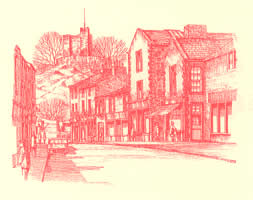
L S Lowry, the Lancashire artist, renowned for his stick figures and styles of industrial and urban scenes, came to Clitheroe several times in the 1950's and 1960's. His sketches indicate an interest in a particular feature of the town - its roofs. Clitheroe is perhaps best described as a roof top town. The variety of roof types viewed against the skyline or Pendle Hill, the church, the castle or against each other is enhanced by the hilly nature of the town. So, keep stopping, keep looking up and enjoy this part of the town's heritage. The buildings themselves are mainly late 18th century and 19th century in origin replacing earlier and sometimes dilapidated structures.
THE MARKET PLACE - provides the starting point. The small triangular or flat iron shaped market place meant that the market often spilled over into Castle Street and Church Street. Directly facing the tourist office is the White Lion, its present day exterior dating from 1839. Its predecessor was badly damaged by lightning and fire in that year. In the wall of the inn the iron rings to which horses were tethered still exist.
Between the Victoria Hotel and the White Lion another inn the Boars Head 1826 - 1913 stood where the Skipton Building Society now stands. If you cross to the archway of the White Lion you will see, framed in the arch (mist permitting) one of the views of Pendle Hill and Wellgate much loved by local people.
THE LIBRARY - Reopened in 1990, extensively redesigned and extended, the building now incorporates the Clitheroe Town Hall and Mayor's Parlour of 1820; the Carnegie Library of 1905; old public lavatories; an early 19th century police station and older still local prison cells. Not many library sites will be able to boast such a variety of earlier uses. The cells form part of the library storage and administration area whilst the Council Chamber of the old Town Hall, retaining its attractive ceiling and leaded windows, is used for lectures and music recitals. The 1820 Town Hall itself replaced a Moot Hall built on the same site about 1620.
Go inside if you have time, find the curved stairway of the original library which will take you to the reference library and old Council Chamber. At the time of writing Clitheroe retains its option of having a Mayor - an option given to old boroughs following the 1974 Local Government reorganisation. Its civic regalia is the envy of many far larger towns and cities. A modern small town hall adjoins the Ribble Valley District Council Chamber both opposite to the library. If the door of the Council Chamber is open peep in, a modest entrance disguises an excellent and roomy chamber. Clitheroe was the second oldest borough in Lancashire, after Wigan. The plaque on the wall of the 1820 Town Hall gives the date of the first charter. Take the road to the left of the library - this is Church Street.
CHURCH STREET AND THE CHURCH - Until 1826 Church Street was the main route out of the town to Chatburn and Skipton. The short walk to the church leads past several very attractive late Georgian houses. On the 1851 census one of these properties is classified as 22 ½. The enumerator found he had missed out this house. Rather than re-number and after his records he lighted upon this unusual method of correction. The solicitor's office, on the left hand side has the date 1808 on the facade near the roof and you will see in the yard at the side, a drainpipe dated 1757.
Go into the churchyard. The noticeboard indicates there has been a church on the site since 1122. In 1828 the present church replaced a smaller Medieval one. The spire, added in the 1840's developed a mini 'Chesterfield' twist which was eventually corrected in 1969. In 1978 the interior of the church was accidentally badly damaged by fire. It was re-dedicated in 1981. Walk along the side of the church towards the spire to be rewarded with an excellent (often windswept) view of distant fells. Return to Church Street.
CHURCH BROW - As soon as we start going downhill, Church Street becomes Church Brow. It was in Church Brow that L S Lowry made one of his sketches looking towards Church Street. On the right are two attractive Victorian houses and a later terrace (1890) where the stone faces on the doorways are now showing signs of wear. Opposite is Prospect House an imposing early Victorian building, whose roof is readily seen from parts of the town. Between 1797 and 1850 the four successive owners of this land went bankrupt! Note on the other side the modern houses (1988) an example of infilling - using space within the town centre. Almost the last building on the right was the first purpose built Sunday school for the church. The St John's Ambulance Brigade used the building as its headquarters for many years, so locally it is still known as St John's Ambulance Hall.
THE ALLEYS AND HAZELMERE - Facing across from the bottom of Church Brow there are two houses of note, firstly a stone built mid Georgian house. Until the late 1870's it was known as Spring Gardens but after that time it has been known as The Alleys. It stands on land close by an earlier moated manor house of the same name dating back to the l4th Century or earlier.
Hazelmere, a contrast in style and materials, is a Victorian mansion built in the late 1880's. An interesting stone set in the boundary wall reads, "Borough Croft late Fishs No 46." It marks the site of one of six crofts named after their owners. These crofts or burgages, about one hundred in all, enjoyed all the privileges of Burgage holdings including the right to vote for Clitheroe's two members of parliament (from 1558-1832). They were therefore properties of value and importance. At the bottom of Church Brow turn right.
ST. MARY'S WELL AND WELL TERRACE - This is one of three similar wells which were the chief sources of water for the people of Clitheroe until the mid 1850's when a piped water supply was introduced. Under the path, between the well and the edge of the road is a stone drinking trough for horses, together with a tiny trough for smaller animals. Following road alterations in the 1920's and 1930's they have been hidden from view except for a few days in 1989 when excavation linked with drainage revealed them.
This terrace is typical of so much late Victorian house building. It is always interesting to note how, in particular, doors have changed in style. It is rare now to see original solid wooden doors, door knobs and small letter boxes. At the end of the terrace is a development of retirement homes (Late 1980s) built on the site of an old corn mill. To the right of the petrol station, partly hidden by trees and shrubs, there is a late Victorian gaslight which stood in the middle of the road near the Royal Oak Inn. Speed, size, volume and frequency of modern traffic meant it had to go!
YORK STREET AND GRAMMAR SCHOOL - Turn right into York Street built in 1826 as part of the new road to Chatburn. John Macadam the well known road engineer was an adviser in the planning of this road.
The building on the right is Clitheroe Royal Grammar School. Founded in 1554 by Queen Mary, the first school was built in 1588, sited in the churchyard. In 1782 a new building was erected, also in the churchyard. In 1834 it was moved, stone by stone, to its present position at the far end of the school yard. This 1782 building has been sympathetically joined (1989) to the larger school, built between 1912 and 1914. These premises now function as the Sixth Form of the school - coeducational since 1985 - the girls' school having an independent existence between 1915 - 1985. The school, now a thriving grant maintained school (1991) must have been close to closure between 1826 and the 1840s when numbers on roll sometimes varied between one and seven!
Walk up York Street. There are some interesting doors on the left hand side and the Civic Hall, which has served as a cinema since 1920. It is well worth peeping in - a journey back in time of some seventy years. Finally, note the heavily studded door on the right hand side of York Street which conceals the town gaol entrance of former years in use until 1880's.
WELLGATE AND HEILD WELL - At the National Westminster Bank, built on the site of an old inn, Dun Horse, turn left into Wellgate. This is one of the oldest thoroughfares in the town, for hundreds of years the start of the road from Clitheroe to Burnley. Harris Court is named after a family, descendants of whom built Preston Library and Art Gallery.
At the bottom of Wellgate is the town or Heild Well. The meaning of the name is not known though it is suggested that this may have been a covered well. Behind the well is the Dog and Partridge Inn rebuilt in 1806 replacing an inn of the same name. It is the oldest of the many rebuilt inns most of which were renovated and restored from 1835 onwards.
LOWERGATE AND CAR PARK - As the trail leads right into Lowergate we are at the oldest junction of roads in the town, i.e. Wellgate, Duck Street, Shawbridge, Lowergate. A short distance along Lowergate, amidst old stone properties the large red brick employment exchange provides a vivid contrast of styles. Built in the early 1860s the Royal insignia on the roof gives proof of its original purpose - the Court House. Carry on straight across King Lane into the car park.
Once again notice a variety of roof outlines, old and new. On the right is another development of retirement properties (1992). Until about 1914 the site served as an inn yard and stabling and has since been a concert hall, a cinema and finally in the 1960s it became the first supermarket in the town; proof that, like it or not, a town must adapt to change.
SWAN AND ROYAL - From the car park climb the flights of steps into the small shopping precinct formed from the old stabling and outhouses of the hotel. The present building dates from the 1830s when it replaced an inn probably dating from the 15th or 16th century. A few years ago a solid oak door of such vintage was found at the entrance to a cellar. The door is now on display at the museum. For most of its existence it has simply been The Swan. Royal may have been added mid 19th century when a royal mail coach ran from Clitheroe to Hellifield. Another reason offered is that it was the office for the Exciseman. To locals it is still The Swan.
CASTLE STREET - Coming from the courtyard look left to see and appreciate the strategic position of the castle keep towering over roofs and buildings spanning the last 200 years.
Walk down to the pedestrian crossing; note the building now occupied by Barclays. Erected in 1870 it was Clitheroe's first purpose built bank. The Yorkshire Bank stands on the site of an old inn, The Brownlow Arms, a property previously the home of James King, Vicar of Clitheroe 1743-1773. One of his sons, born in the town and educated at the Grammar School, sailed with Captain Cook. Cross the crossing; King Street (not part of the trail) is largely a late Victorian development stimulated by the building in 1870 of the railway station at the bottom of the street.
Now walk past Woolworths, turn into the Starkie Arms archway rebuilt in the 1830s replacing the Rose and Crown quite possibly dating from Tudor Times. Go to the end of the yard for a fascinating view of the fells and market area. Since 1988 the council and residents have been considering how best to re-develop this vital area of the town. For more than 100 years it has been the Auction Mart site. Many thousands of cattle, sheep and horses have been bought and sold here. It is important we get it right but we cannot wait for ever. Re-trace your steps to Castle Street. Finally on the way to the Castle entrance look out for an entry with 'Lee Carter Health Studio' above it (1993). A stroll down is certainly of interest. One mid Victorian census - counted 60 - 70 people in the three cottages which were used as common lodging houses.
THE CASTLE AND GROUNDS - The town trail officially ends at the castle entrance. A visit takes about two hours and includes an interesting keep, curtain walls, formal and informal grounds, plus much more to keep your interest.
This village stroll produced courtesy of Ribble Valley Borough Council
Other walks nearby
| Walk 2938 | Nick of Pendle from Pendleton | easy/mod | 6.3 miles |
| Walk 1818 | Downham & Pendle Hill | moderate | 8.0 miles |
| Walk 1655 | Downham & Pendle Hill (short version) | moderate | 6.3 miles |
| Walk 2632 | The Ribble Valley from Sawley | easy/mod | 9.0 miles |
| Walk 1267 | Pendle Hill | moderate | 5.0 miles |
| Walk 1287 | Circuit of Pendle Hill | moderate | 8.5 miles |
| Walk 2720 | Pendle Hill (use in mist) | moderate | 5.0 miles |
| Walk 2384 | Hodder Valley from Whitewell | easy/mod | 6.8 miles |
| Walk 2216 | Slaidburn Village Trail - Ribble Valley | easy | 0.8 miles |
| Walk 3329 | Stocks Reservoir from Slaidburn | moderate | 11.5 miles |
Recommended Books & eBooks
Walking on the West Pennine Moors
 This guidebook describes 30 walks on the West Pennine Moors, around Blackburn, Darwen, Chorley and Bolton, home to some of the most inspiring and exhilarating walking country. The walks range from short, easy rambles to more challenging hikes covering a variety of terrain, all of it easily accessible for day walking.
More information
Messaging & Social Media
Message Walking Britain and follow the latest news.

Mountain Weather
Stay safe on the mountains with detailed weather forecasts - for iOS devices or for Android devices.