Walk 2219 - printer friendly version
The Avon Dam Reservoir from Shipley Bridge Walk
Author - Lou Johnson
Length - 3.5 miles / 5.7 km
Ascent - 410 feet / 124 metres
Grade - easy
Start - OS grid reference SX680629
Lat 50.451047 + Long -3.8606656
Postcode TQ10 9EL (approx. location only)
A pleasant valley following the River Avon with a gentle climb up to the shores of the Avon Dam Reservoir make this a relaxing walk that is ideal for pushchairs and the less mobile. The change from woodland to open moorland is quite dramatic and you get the experience of being in wild Dartmoor as you sit beside the reservoir.
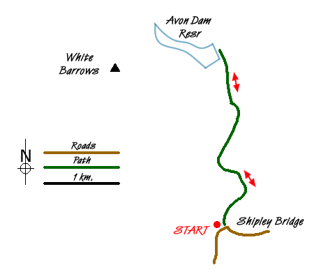
This easy walk starts from the car parking area at Shipley Bridge (grid ref. SX680629). To get here you need to use the lanes (narrow in places) that lead from South Brent or the junction of the A38/A385 just to the east of the village.
After parking follow the River Avon upstream on a tarmac road. The walking is pleasant and you soon make good progress. Pass beside a metal gate and shortly after notice the remains of Brent Moor House on your left. After a number of uses since WW2 the building was eventually demolished in 1968. Crossing a bridge the landscape becomes wilder.
After another 600 metres you get your first view of the dam. You will soon see a track veering right off the tarmac lane. This takes you up to the shores of the reservoir. If you want to stay on tarmac then continue ahead to the base of the dam. However for a little more effort the rougher route up the stony track is better. You get a good view across the reservoir and also down into the valley where you have just walked.
To return to the start all you need do is follow the outward route in the opposite direction.
Messaging & Social Media
Message Walking Britain and follow the latest news.

Mountain Weather
Stay safe on the mountains with detailed weather forecasts - for iOS devices or for Android devices.