Tarns of Eskdale
Lake District Walk
Nat Park - Lake District - Lake District Southern Fells
County/Area - Cumbria
Author - Peter Smyly
Length - 7.5 miles / 12.2 km Ascent - 1500 feet / 455 metres
Time - 5 hours 20 minutes Grade - easy/mod
Maps 

| Ordnance Survey Explorer OL6 | Sheet Map | 1:25k | BUY |
| Anquet OS Explorer OL6 | Digital Map | 1:25k | BUY |
| Ordnance Survey Landranger 90 | Sheet Map | 1:50k | BUY |
| Anquet OS Landranger 90 | Digital Map | 1:50k | BUY |
Walk Route Description
Click image to see photo description.
This Lake District walk does not feature any summits but takes in five of the Eskdale tarns in Lakeland, three tarns of note and two much smaller tarns, which do not merit much attention. Eskdale is one of the quietest but prettiest valleys of Lakeland and was a favourite valley of the late Alfred Wainwright, the famous Lakeland author, who described it as "the finest of all valleys".
The easiest approach to Eel Tarn is from the Woolpack Inn. However, in order to include Stony Tarn as part of a roughly circular route, this walk heads for Stony Tarn first. Follow the path from Wha House Farm as if heading for Slight Side on the way to Scafell. To locate Stony Tarn involves leaving the path. This is not the easiest of approaches to Stony Tarn, however, and even in good visibility can present navigational difficulties. This is due to pathless terrain which comprises a succession of rises and hollows of similar height and composition. Stony Tarn is inclined to remain elusively hidden when approached from this direction.
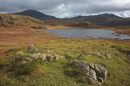
The lack of a clear path and its not being en route to a mountain summit means that Stony Tarn tends to be seldom-visited. This is a pretty water and is seen to good effect from different angles. It is overlooked by hills on two sides including to the south which explains why it remains out of sight from the top of Harter Fell across the Eskdale valley.
To reach Eel Tarn from Stony Tarn, there is no path, but the task is straightforward enough provided that you follow a more or less straight course from the outflow of Stony Tarn to the south west. Eel Tarn is only about half a mile away and is seen in the distance as you descend. It is rather boggy around the edges so is most likely to be seen from a distance. By bearing right (north west) from the tarn, a clear path (which comes down from Burnmoor Tarn) is located that heads south west and which leads down to the hamlet of Boot.
To reach the next tarn, Blea Tarn, climb up steep, pathless felllside from near Dalegarth Station on the miniature railway, leading to Blea Tarn Hill. Although by climbing to the top of the hill, there is additional height gain, compared with making for the tarn directly, the extra effort is worthwhile for the fine view of the tarn from the top of the hill. A clear path leads down and along the east shore of the tarn to the outflow. A short digression to the right reveals a further two tarns - Siney Tarn and Blind Tarn though both are very small and rather overgrown and it is perhaps surprising they were considered worthy of having names at all. Nearby Blea Tarn is considerably larger and more picturesque. A clear path now leads down to the south east from near the outflow of Blea Tarn to rejoin the Eskdale valley below at Beckfoot Station. While it is possible to return to the start point by following the road back all the way, a route variation involves taking the next turning on the right and then following the path alongside the River Esk, passing Low Birker Farm on the right before the path rejoins the road shortly before the Woolpack Inn. There tends to be little traffic on this secondary road, in any case.
Other walks nearby
| Walk 2226 | The Scafells | very hard | 12.0 miles |
| Walk 1916 | Harter Fell and Low Birker Tarn from Hardknott Pass | moderate | 6.5 miles |
| Walk 3419 | Scafell Pike an Eskdale circular | very hard | 12.5 miles |
| Walk 2467 | Green Crag & Harter Fell | moderate | 7.9 miles |
| Walk 2355 | Blea Tarn & Eskdale Green | easy/mod | 6.5 miles |
| Walk 1668 | Silver Knott & Muncaster Fell from Irton Road | easy/mod | 5.0 miles |
| Walk 3485 | High Birkhow & Low Wood from Wast Water | easy | 4.2 miles |
| Walk 1176 | Yewbarrow | moderate | 4.5 miles |
| Walk 2341 | Circuit of Nether Beck and Over Beck from Wasdale | hard | 11.3 miles |
| Walk 1690 | Netherbeck Horseshoe - Middle Fell, Steeple & Red Pike from Wasdale Head | mod/hard | 12.5 miles |
Recommended Books & eBooks
Walking the Lake District Fells - Langdale
 Part of the Walking the Lake District Fells series, this guidebook covers a wide range of routes to 25 Lakeland summits that can be climbed from the Great Langdale valley, Ambleside and Grasmere, with highlights including Scafell Pike, Bowfell, the Langdale Pikes and Helm Crag (the Lion and the Lamb). Includes suggestions for longer ridge routes.
More information
Outdoor Adventures with Children - Lake District
 Guidebook to 40 outdoor adventures in the Lake District with children under 12, including walking, cycling, orienteering, paddling, boating, hostelling and more. Graded activities for varying age ranges or for families with children of different ages.
More information
Messaging & Social Media
Message Walking Britain and follow the latest news.

Mountain Weather
Stay safe on the mountains with detailed weather forecasts - for iOS devices or for Android devices.