The Eastern Edges
Peak District Walk
Nat Park - Peak District - Black Hill Dovestone
County/Area - South Yorkshire & Derbyshire
Author - Jake Robertson
Length - 25.0 miles / 40.6 km Ascent - 4000 feet / 1212 metres
Time - 16 hours 30 minutes Grade - hard
Maps 

| Ordnance Survey Explorer OL1 | Sheet Map | 1:25k | BUY |
| Anquet OS Explorer OL1 | Digital Map | 1:25k | BUY |
| Ordnance Survey Landranger 110 | Sheet Map | 1:50k | BUY |
| Anquet OS Landranger 110 | Digital Map | 1:50k | BUY |
Walk Route Description
Click image to see photo description.
The famed Eastern Edges stretch for nearly forty miles from Dunford Bridge in the north to Ambergate in the south and the traverse of the principle edges is a superb and highly rewarding day out, albeit a challenging one too; requiring plenty of time and energy.
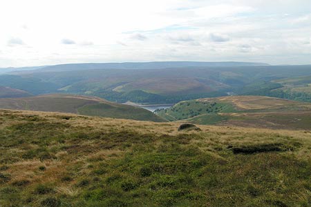
The start of this Peak District walk is the car park near Langsett (Grid ref SE201010). Leave the car park (Grid ref SE201010), cross the road and walk down on the left for a few yards to take a track on the right through the forest to a crossroads. Go left, dropping down to cross the Little Don over an attractive footbridge then climb out of the valley and onto the moors. This track is known as Cut Gate, an old packhorse route from the Derwent Valley to Penistone and it makes a steady climb onto Mickleden Edge before winding its way through peat hags to a small cairn on its summit (Grid ref SK186961).
Head south (left) over the moor to the trig point on Margery Hill (546m) then veer right to pick up the path along the spectacular Howden Edge and up to High Stones, at 550m the highest point on the Eastern Edges and the county top of South Yorkshire. This is a tremendous viewpoint and well worth a pause at with Back Tor, the next objective, looking a long way from here! Continue along the edge but soon fork left on a path to the Wet Stones and contour above Gravy Clough to make a very steep descent by Foul Clough. Cross Abbey Brook in its deep ravine (Grid ref SK197925) then pick up the track heading up Sheepfold Clough and onto Lost Lad Hillend where a stone flagged path is joined.
It is an easy walk along the bumpy ridge, passing the viewfinder on Lost Lad, to the summit rocks of Back Tor, arguably one of the finest hills in Peakland. On a clear day when the extensive and perfectly balanced panorama is fully visible, encompassing plains, water, forests and mountains with civilisation a satisfying distance away there are few, if any, viewpoints that are finer than this.
Descend on the flagged path down Derwent Edge, easy walking passing its many famous tors until just after the Wheel Stones where you turn left on a path signed "Moscar" (Grid ref SK203880). Take this path down off the moor until after passing through a gate you climb over a stile on the right and make you way through a boggy area to the farm, emerging onto Mortimer Road (Grid ref SK225878). Go right down the road to its junction with the busy A57 then left up the road for a short way to a lay-by near Moscar Lodge. Cross the road and make the steady climb on a good path up to Stanage End. There can be no denial about this section from the Wheel Stones to Stanage End. It is tedious and demoralising walking with the climb a seemingly endless drag. But persevere you must! Once Stanage End is gained the walking picks up and the rest of the route is a delight and all the hard work of the day is done.
Simply make your way along Stanage Edge, a magnificent bound passing the two trig points, both superb viewpoints. Continue on the path dropping down off the edge near the Cowper Stone across Cam Height to Upper Burbage Bridge. Cross the two bridges then go through a gate and make your way along the top of Burbage Rocks (also Burbage Edge). There is a slight drop before the second edge is picked up and you want to leave it just before the cliffs end (Grid ref SK266809), a vague path leads over a stile over the moor to the road just above the Fox House Inn.
Walk down to the Fox House Inn. Cross the road at the corner and pass through a gate into the Longshawe Estate. Turn immediately left and follow a path between the road and car park to a gate. Then climb up onto the unnamed edge. An easy walk south brings you to the road junction by the Wooden Pole. Cross the road and take the second path on right for a damp climb up onto White Edge Moor. It's a wonderfully easy few miles bound along White Edge with the crowds on Curbar and Froggat below. A little beyond the trig point the path starts to descend and ignoring the turn off to Curbar Gap you pass beneath Swine Sty and over a tussocky moor to the road near a crossroads (Grid ref SK277742) with Birchen Edge, the final objective rising up ahead.
Go straight over at the crossroads and go through a gate on the right along a damp path which leads up towards Birchen Edge. When you near the edge leave the path and scramble up to the trig point (310m). Walk down the edge past the famed Three Ships boulders, descending steeply when the rocks end. A short walk on a grassy path brings you to the road (SK 282/721), the Robin Hood Inn a short way down on the right. After such a walk a pint is more than well deserved!
NOTE - Stronger walkers may wish to add a few extra edges into the walk. Crow Stones Edge and Outer Edge could be easily included if an alternative start at King's Tree is used. A few more edges cab be added by crossing from White Edge trig point onto Curbar Edge and walking along Baslow Edge, Gardom's Edge and then onto Birchen Edge. Chatsworth Edge and Harland Edge could also be tagged onto the end with a finish at Beeley.
Other walks nearby
| Walk 1581 | Langsett Reservoir | easy | 3.0 miles |
| Walk 3401 | From Langsett to Crowden via Woodhead | moderate | 11.0 miles |
| Walk 2826 | Winscar Reservoir circuit from Dunford Bridge | moderate | 8.9 miles |
| Walk 2726 | Penistone Circular from Scout Dike Reservoir | moderate | 8.3 miles |
| Walk 2328 | Penistone to Shepley linear | easy/mod | 8.0 miles |
| Walk 1523 | Broomhead Moor & Ewden Beck | easy/mod | 6.0 miles |
| Walk 2238 | Thurgoland Boundary Walk Oxspring | easy/mod | 8.6 miles |
| Walk 1522 | Back Tor, Bradfield Moors and Reservoirs | moderate | 11.0 miles |
| Walk 1687 | Broomhead & Howden Moors | moderate | 12.4 miles |
| Walk 3049 | Bleaklow Stones from Derwent Valley | mod/hard | 12.0 miles |
Recommended Books & eBooks
Great Mountain Days in the Pennines
 An inspirational guidebook to 50 classic walks on the rolling Pennine landscape. The graded routes, between 6 and 13 miles in length, cover classic Pennine fells and moorland such as Whernside, Ilkley Moor and Pendle Hill; exploring the North and South Pennines, Yorkshire Dales, Howgills and Dark Peak. Many routes are also suited to fell running.
More information
Walking in the Peak District - White Peak East
 Guidebook describing 42 half-day and day walks in the limestone landscapes of Derbyshire's White Peak, part of the Peak District National Park. One of two volumes, this book covers the east of the region, with potential bases including Bakewell, Eyam, Castleton, Birchover, Matlock and Wirksworth.
More information
Messaging & Social Media
Message Walking Britain and follow the latest news.

Mountain Weather
Stay safe on the mountains with detailed weather forecasts - for iOS devices or for Android devices.