Walk 2233 - printer friendly version
Flash & Three Shires Head Walk
Author - Lou Johnson
Length - 6.2 miles / 10.1 km
Ascent - 900 feet / 273 metres
Grade - easy/mod
Start - OS grid reference SK008699
Lat 53.2261440 + Long -1.9894749
Postcode SK17 0TG (approx. location only)
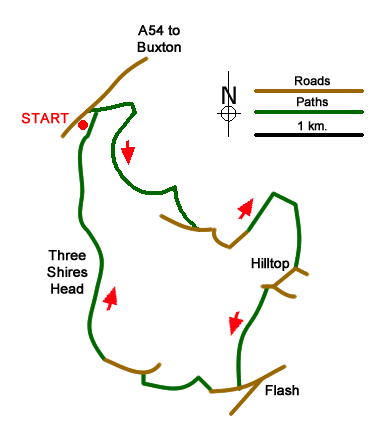
The start of this Peak District walk is a small parking area beside the A54 near Danebower Hollow on the A54 Congleton to Buxton Road at grid ref SK008699. The route uses sections of once-important packhorse routes as well as other paths and quiet country lanes. Route finding is generally good although a 1:25000 map is an asset as there are many paths (some ill-defined) that can cause confusion.
After parking descend down either a path beside the wall or a steeper path closer to the old chimney. At the bottom you turn left along the Dane Valley Way (the main valley path). This leads through the spoil heaps of Danebower Quarries. Follow the clear path as it drops down to cross a stream. The path then climbs and weaves its way through Reeve-edge Quarries. The track contours across the western flank of the hillside continuing above Blackclough. Stay on the main track as it enters a side valley and continues towards Orchard Farm.
Leave the track before the farm following the Dane Valley Way as it descends to a minor road (grid ref. SK019687). Turn left along the road and bear right almost immediately along a rough track which leads to another lane (SK020686). Bear right along this lane to the next junction by Readyleech Green. Turn left here along Drystone Edge. Continue northeast to where a track leads east (grid ref. SK026690). Follow this track which soon heads south and becomes a lane. Reaching a junction with a road (grid ref. SK029683), go right and continue to a junction. Turn right and just past Oxenstitch take the signed footpath on the left (grid ref. SK026681). Follow this path to reach the road at Flash (grid ref. SK024671).
Turn right down the lane and take the first footpath on your right. This leads across a field to join the access track to Axe Edge Green Farm. The public right of way veers half left from the farm drive and continues down towards a valley. Continue ahead at a path junction to reach the buildings at Wicken Falls (grid ref. SK0146710). Turn right before the buildings and ascend to a tarmac lane. Turn left and continue past cottages (grid ref. SK011673) to join a rough track.
Stay on what is now a rough track and continue to Three Shires Head. Cross the River Dane on the pretty packhorse bridge and immediately turn right. You are now on the Dane Valley Way. This will lead you up the valley and soon you will see the familiar sight of the chimney passed in the early stages of the walk. After passing a derelict office building, turn left up to the road back to where you parked.
Messaging & Social Media
Message Walking Britain and follow the latest news.

Mountain Weather
Stay safe on the mountains with detailed weather forecasts - for iOS devices or for Android devices.