Walk 2245 - printer friendly version
Winter Hill & Rivington Pike Walk
Author - Lou Johnson
Length - 6.0 miles / 9.8 km
Ascent - 1000 feet / 303 metres
Grade - easy/mod
Start - OS grid reference SD637146
Lat 53.6266650 + Long -2.5503407
Postcode BL6 7SD (approx. location only)
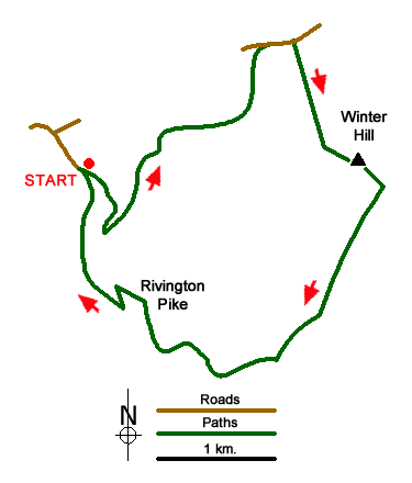
This Lancashire walk visits two excellent viewpoints, crosses a section of wild moorland and provides some good exercise. The start is the car parks at grid ref. SD637146 variously known as Lower House and Belmont Road car park. In good weather these can be very busy with people making an ascent of Rivington Pike.
Exit the car park on the south side, go through the metal barrier and take the left-hand track. This track climbs steadily for 600 metres to reach a junction of tracks bear the Pigeon Tower (grid ref. SD639143). Turn sharp left here onto Belmont Road. Following an almost level route, Belmont Road is followed for about 2km to reach Rivington Road (grid ref. SD653158). Bear right for a short way and turn right through a kissing gate onto a moorland path.
This path initially climbs beside a wall (on your right) with the masts on Winter Hill in view all the time. The going can be wet under foot after rain. The path wall becomes a fence and the gradient steepens as height is gained. Reaching the summit, the clutter of modern day communication does not spoil the panorama over the surrounding areas from the OS trig point.
Follow the surfaced service road southeast, turning right at a 'crossroads' before the last mast. Continue past the TV station on your left and continue downhill on a clear track following the Rotary Way. After 800 metres (grid ref. SD657136) just where the track starts to bend slowly to the left, turn right onto a clear footpath heading southwest. This is the continuing route of the Rotary Way. The path crosses wild moorland and leads down to Georges Lane at Pike Cottage (grid ref. SD648131).
Turn right along Georges Lane which soon becomes Belmont Road. The track bends to the left and then right to reach a junction of tracks and paths at the foot of Rivington Pike (grid ref. SD644134). Turn right here and in a short way veer left onto a well-worn path leading to the summit Rivington Pike where an excellent view can be enjoyed.
From the summit walk west initially down a steep path and re-join Belmont Road (grid ref. SD640138). Turn left and then take the first path on the right which descends down to a track. Bear right and you are soon back at the car park and the starting point of the walk.
Messaging & Social Media
Message Walking Britain and follow the latest news.

Mountain Weather
Stay safe on the mountains with detailed weather forecasts - for iOS devices or for Android devices.