Grindon & the Manifold Way from Waterhouses Walk
Walk 2263 - Route Maps
Route Map
Digital Maps - Copyright © 2011-2024. All rights reserved.
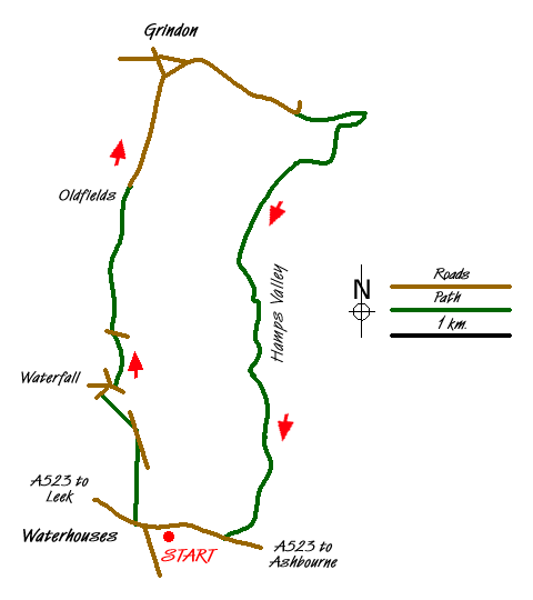
Sketch Map
Suggested Maps 

| Ordnance Survey Explorer OL24 | Sheet Map | 1:25k | BUY |
| Anquet OS Explorer OL24 | Digital Map | 1:25k | BUY |
| Ordnance Survey Landranger 119 | Sheet Map | 1:50k | BUY |
| Anquet OS Landranger 119 | Digital Map | 1:50k | BUY |
It is recommended you take a map. The preferred scale is 1:25k.
Start Point Details
Ordnance Survey Grid Ref SK085501
Latitude 53.048097 Longitude -1.874657
Postcode ST10 3JS
what3words start views.sharpened.ranking
Walk description may contain detailed information on the start point for this walk.
Further Information
Peak District
Walking in the Peak District is some of finest in the UK. The National Park suffers from a split personality with its contrasting White and Dark Peaks. Within easy distance from Manchester, Sheffield and the Midlands there is much for the visitor to see. The contrast between quiet limestone dales and wild upland moors provides the basis for a diverse range of Peak District walks with scenic variety the keynote. Peak District Walking Guide
Staffordshire
The County of Staffordshire is located within the Midlands. The northern part of the county includes part of the Peak District National Park featuring both Gritstone moorland of the Dark Peak and limestone dales of the White Peak. To the south the heathlands of Cannock Chase form part of a National Landscape (formerly AONB). Elsewhere the county is predominantly rural with pleasant countryside and easy walking.
Walk grading - Learn how each walk is assessed and select a walk to suit your ability and experience by going to Walk Grading Details.
Messaging & Social Media
Message Walking Britain and follow the latest news.

Mountain Weather
Stay safe on the mountains with detailed weather forecasts - for iOS devices or for Android devices.