Walk 2299 - printer friendly version
The Cheviot Walk
Author - Paul Gasson
Length - 9.0 miles / 14.6 km
Ascent - 2100 feet / 636 metres
Grade - moderate
Start - OS grid reference NT881225
Lat 55.496141 + Long -2.1899103
Postcode NE71 6TU (approx. location only)
The Cheviot, at 815 metres, is the principal hill in Northumbria, and a somewhat secretive one at that, with no close road access. The summit hardly rises above the boggy plateau on which it is situated, and whilst the shortest route to it is probably from the end of the road in the valley of the Harthope Burn, over Scald Hill, this route holds far more interest.
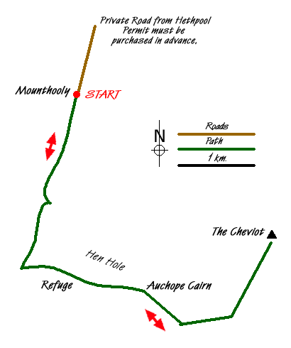
The Mounthooly Bunkhouse (recently refurbished), is located at the end of a long private road in the College Valley. Other than residents, a permit is required and can be obtained online from www.college-valley.co.uk. There is a free car park at the entrance to the valley, but believe me, the fee is well worth it!
Leave the car on the grass just before the gate to Mounthooly, pass through the gate and behind the buildings following a clear track alongside the infant College Burn, through a number of gates, and eventually into open rough pasture and a waymarker. Here it is possible to follow the left hand branch of the stream into a deep valley, clearly visible up ahead, and enjoy some easy scrambling on either side of the stream, into the Hen Hole. There are several tales about the Hen Hole, probably the best known being that of Black Adam of Cheviot, a notorious outlaw, who gatecrashed a wedding party in Wooperton, robbed the guests, raped and murdered the bride then made his escape, hotly pursued by the groom, to the Hen Hole, where they scrambled up the rocks and made a 20ft. leap across the ravine to Black Adams cave, where they fought until both men fell to their deaths in the College Burn below.
The route scrambles alongside the Three Sisters Falls, and some lesser cascades, and eventually exits right up very steep grass to gain the main route at the Auchope Cairn, but our path continues straight ahead at the marker post, climbing steeply above a shaley ravine, known as the Red Cribs on account of their colour, until, at the top of the rise the Pennine way is met, running alongside a substantial fence. This is the Border Fence, marking the end of England and the start of Scotland! Turn left here and, at the top of the slightest of rises you come to a mountain refuge hut, the Stuart Lancaster Memorial Hut, named after a walker who died in a snowstorm near here. Whilst the hut is small and contains only a wooden bench it can offer welcome refuge to anyone caught here in a winter blizzard, or even a summer downpour! The view from here back down the College Valley makes it an inviting lunch spot.
Continuing on from the hut, the Border Fence on your right, drop down to a col before a steep climb up to the Auchope Cairn and it's 'Stone Men'. These are two, recently restored, rough stone pillars that look from a distance like two walkers bending into the wind. Auchope Cairn is regarded as the best view in Northumbria (mists permitting!), enjoying extensive views in every direction, and marks the start of the summit plateau. After the pull up to the Cairn, it is a welcome relief to note that the path now goes slightly downhill, still roughly following the Border Fence, and very soon meeting the boardwalk which has been installed to prevent erosion of the vulnerable peaty moor. This is followed to a sharp right turn in the Fence and the Pennine Way, and a signpost, somewhat out of place in this wild spot.
The sign does however point the way to The Cheviot, and, after negotiating a couple of stiles and a boggy patch we are on our way, leaving the Pennine Way and the Border Fence and soon coming across a stone flagged path across the moor, the flags mostly recycled from disused cotton mills, still with a fence to our right. The path rises marginally to Cairn Hill, with an enormous cairn (more a big pile of stones!), known as Scotsman's Cairn just beyond the fence. The stone flags lead us unerringly to the large cairn and triangulation pillar marking the summit of The Cheviot, near a pool, the size of which varies greatly dependant on the amount of rain recently!
The return is to reverse the outward route, with, if required, a slight variation at the col below the refuge hut. Leave the Pennine Way right and make your way over to the start of the slope down. Here, at NT880201, you will locate an obvious grassy track (marked on the 1:2500 OS map OL16), which zig zags down into the valley. It becomes less distinct once the slope is left behind, but continue in the same direction to meet the outward path near the marker post referred to earlier. Go right to return to the car.
Messaging & Social Media
Message Walking Britain and follow the latest news.

Mountain Weather
Stay safe on the mountains with detailed weather forecasts - for iOS devices or for Android devices.