Walk 2301 - printer friendly version
Biggin & Parsley Hay from Hartington Walk
Author - Lou Johnson
Length - 9.5 miles / 15.4 km
Ascent - 1100 feet / 333 metres
Grade - easy/mod
Start - OS grid reference SK128605
Lat 53.1414980 + Long -1.8101033
Postcode SK17 0AW (approx. location only)
Using a variety of field paths, quiet lanes, walled tracks and a former railway, this Peak District walk explores the area to the north of then busy village of Hartington. The route lies wholly within Derbyshire although in the latter part of the walk good views into neighbouring Staffordshire are also enjoyed.
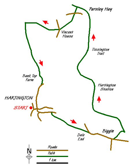
Hartington can be very busy even in the winter. Parking on the street is usually possible and after finding a space locate the pond in the centre of the village (Grid ref. SK128605). With your back to the pond and facing the main road through the village, walk to the left along the main road (B5054) towards Newhaven. After a short distance, take the lane on the right (Hall Bank) and walk uphill past the very grand Youth Hostel on your left.
Just past the Hostel take the footpath signed on the right (Grid ref. SK132603). This takes a diagonal line across two fields into a walled lane (Highfield Lane). Walk southeast along this lane through scenery typical of this area to reach a tarmac road at Dale End (grid ref. SK147595). Turn right along the road and at the junction take the left fork into Biggin. Pass the church on your right, and a few metres past the road junction take the signed footpath on your left (Grid ref. SK155593). This leads across fields to the Tissington Trail. Turn left onto this former railway. The going is fast and you soon arrive at the former Hartington Station with its preserved signal box. There are picnic benches and toilets here.
Continue along the Tissington Trail as it meanders across the countryside to reach a junction with the High Peak Trail. The Tissington Trail ends here and you continue ahead following the High Peak Trail through Parsley Hey Station (refreshments in season, toilets etc.). After 400 metres turn left down a signed footpath (Grid ref. SK142639). This leads you down to Darley Farm and a road. Cross the road and continue on the footpath opposite, which climbs across open pastures before descending to Vincent House. Do follow the clearly signed route through the latter property to reach a lane. Cross the lane and take the poorly marked footpath opposite. This climbs steeply at first before turning northwest to follow a shallow valley past a dew pond to reach a junction of paths (grid ref. SK124633).
Turn left here and climb out of the valley. On your right lies the Upper Dove Valley with the far bank in Staffordshire. The way ahead is clear as this path is well walked. Reaching sight of the large farm at grid ref SK129615, do not be tempted to descend to the road that leads to and from the farm. Instead stay at high level and continue on the footpath to reach a lane (grid ref. SK130612). Turn right along the lane and return to the centre of Hartington.
Messaging & Social Media
Message Walking Britain and follow the latest news.

Mountain Weather
Stay safe on the mountains with detailed weather forecasts - for iOS devices or for Android devices.