New Waltham Circular
Lincolnshire Walk
County/Area - Lincolnshire
Author - John Coombes
Length - 4.5 miles / 7.3 km Ascent - 50 feet / 15 metres
Time - 2 hours 20 minutes Grade - easy
Maps 

| Ordnance Survey Explorer 284 | Sheet Map | 1:25k | BUY |
| Anquet OS Explorer 284 | Digital Map | 1:25k | BUY |
| Ordnance Survey Landranger 113 | Sheet Map | 1:50k | BUY |
| Anquet OS Landranger 113 | Digital Map | 1:50k | BUY |
Walk Route Description
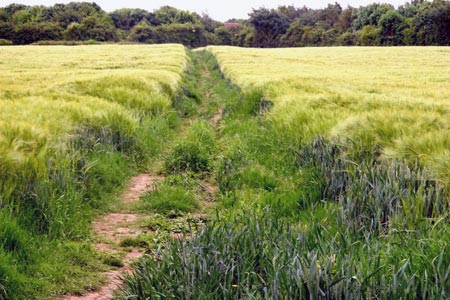
Click image to visit gallery of 5 images.
This is a magnificent circular walk taking in the wonderful Lincolnshire country side with its open space and fresh air with the light fragrance of the wild flowers. The walk just touches the outskirts of Holton le Clay, then picks up part of the old disused East Lincolnshire railway line back into the village of New Waltham. The beauty of this walk is it can be extended to Louth and/or Holton le Clay and beyond.
New Waltham is situated between the two villages Waltham and Humberston, and the village itself was created in the earlier 1960's. The main road through the village is Station Road / Humberston Avenue and this was named after the former station on the East Lincolnshire railway operating from Grimsby to Louth, going straight through the centre of the village.
Some of the landmarks in this area are like the Old Waltham Windmill which was originally built in 1666 but unfortunately was blown down on several occasions, the last time it was rebuilt was back in 1873. The East Lincolnshire railway was once important to the area but finally in the 1980's track lifting started on the Waltham rail track this was designated by Humberside County Council for the building of the A16 Peaks Parkway.
Walk Description
The walk starts in Hewitt's Avenue just past the little side road of Weelsby View were there is parking along some of the side roads in this area. Once past Weelsby View on the right is a narrow path marked with a public footpath sign. Follow the path around to the right and crossover Buck Beck a stream running through the edge of the field. Then head off across the field following the well defined footpath in a diagonal direction to a small gap between the trees.
Go through the gap and follow the footpath around to the left on the edge of a housing estate. The path follows on through the woods with a beautiful avenue of trees which finally leads out into a open area. Then follow a small network of paths through the labyrinth of alleyways to finally reach Humberston Avenue via a metal divider to prevent cyclist from going straight on to the road. Turn left on to Humberston Avenue and walk a short distance ( 20 metres), then cross the road and go down a narrow alley between two houses.
This leads down into a large open field with a clearly defined path ( at the time of writing the field was full of rape oil seed in places up to 5 feet high). Follow the path in the direction of a small wood, keep to the left of the wood to pick up a wide grassy track. Continue down the track to a multi connection of paths turn right and then almost immediately turn left in a diagonal direction, go past a pond on the right and head towards the right corner of a very large red brick house.
Once at the house keep to the left and follow the gravel drive down towards a lane, before the lane and about 150 metres down drive take the path to the right, this is marked midway along with a single tree. Carry on along the path to the end and go through a gap in the hedge to join part of the old disused railway track.
Follow the track all the way back to finally reach Station Road. Go through the gate and turn right, cross the road carefully and take the first turning left, then head down Peaks Lane and follow all the way back to Hewitt's Avenue, then carry on back to the parked car.
Other walks nearby
| Walk 2070 | Tetney Lock and the Humber Estuary | easy | 4.5 miles |
| Walk 2722 | Covenham St. Bartholomew & the Reservoir | easy | 4.8 miles |
| Walk 1984 | Nettleton Beck from Rothwell | easy/mod | 8.4 miles |
| Walk 1511 | Caistor and Nettleton | easy | 4.0 miles |
| Walk 1649 | Spurn Head from Kilnsea | easy/mod | 8.5 miles |
| Walk 1914 | Louth, South Elkington, Hallington & Raithby | easy/mod | 7.5 miles |
| Walk 3224 | Tealby, Walesby, Claxby & Normanby-le-Wold | moderate | 10.5 miles |
| Walk 1712 | Tealby & Risby circular | easy | 3.5 miles |
| Walk 1817 | Walesby from Tealby circular | easy | 5.0 miles |
| Walk 1611 | Tealby and Kirmond le Mire | easy/mod | 7.5 miles |
Recommended Books & eBooks
No suggestions for this area.Messaging & Social Media
Message Walking Britain and follow the latest news.

Mountain Weather
Stay safe on the mountains with detailed weather forecasts - for iOS devices or for Android devices.