Walk 2325 - printer friendly version
Troutsdale Circular Walk
Author - Andy Chaplin
Length - 10.1 miles / 16.4 km
Ascent - 1090 feet / 330 metres
Grade - moderate
Start - OS grid reference SE916867
Lat 54.2677640 + Long -0.5950405
Postcode YO13 9EG (approx. location only)
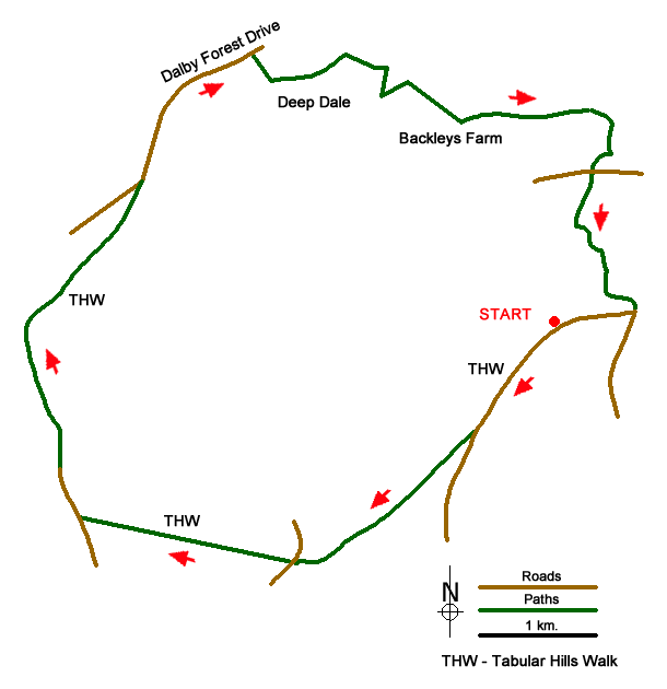
This North York Moors walk starts at Cockmoor Hall car park (grid ref. SE916867) and uses some of the Tabular Hills walk and the Moor to Sea cycle route around Dalby Forest and Troutsdale. There is a remoteness about the area that belies the fact that it is only 12 miles from Scarborough. There are some good views into Troutsdale valley and also into the upper Derwent valley. The point at which you cross the White beck is a very pleasant and secluded valley but do not expect the countryside to be too spectacular as the expanses of forest block in some of the views, even at the observation point at Highwood Brow.
You are frequently reminded that this is an area of working countryside. It is a combination of farming and forestry and you also pass two Third Energy gas extraction sites (not fracking) where you can take a view about its effect (or lack of one?) on the North Yorkshire Moors Park.
Take the Tabular Hills path from the parking westwards through the Cockmoor Hall plantation to the road near Givendale Head farm. Turn right, pass the farm and keep on the road then on the track all the way to the Dalby Forest Drive road. All of this is periodically signed as the Tabular Hills walk.
When the THW bears off left on the New Road track keep on the road then just before the parking at the top of Bickley Gate turn off right on a track into the trees. Ignore the first track on the left and continue for 25m until a track angles off left, downhill past a seat then along the north side of Deepdale. Bear right at a fork in the tracks to the houses at the bottom of Deepdale (grid ref. SE920910) between Wainess Hill and Old Will?s woods.
Cross White Beck and take the bridleway that dog-legs up through Old Will?s Wood to the track at the top where the bridleway clearly continues straight on to Backleys Farm. Take the farm track off to the left and continue on the bridleway through White/Backleys Wood and then down towards Estell Lane. The Derwent valley is now on your left. Either continue along the bridleway/lane to the road or preferably take the (not well defined) footpath off on the right that also comes out on the lane.
Cross over the road and take the Moor Road track up to Highwood Brow. This is signed as part of the Moor to Sea network of cycle routes. There is an information board at the top and views back down into the Sow Beck and Derwent valleys.
Take Cockmoor road on the right (the Tabular Hills walk) along the top of Troutsdale Brow where there are views down into Troutsdale with the option of going off right to the Raptor viewpoint (grid ref. SE935889). Continue along the past the conifer nurseries then bear off right on the track (still the Tabular Hills walk) back to the car park.
Messaging & Social Media
Message Walking Britain and follow the latest news.

Mountain Weather
Stay safe on the mountains with detailed weather forecasts - for iOS devices or for Android devices.